25/08/2020-31/08/2020
The French community maps defibrillators for one month 1 | © Copyright 2020 ProjetDuMois.fr
Mapping
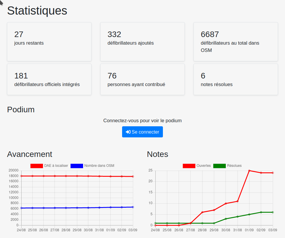
- [1] Since 4 August the French community has been discussing
 > the project of the month for September (defibrillators) in detail on the mailing list talk-fr. Anyone wishing to participate can now read up on the wiki > what to do and which tools are available. The project includes > daily evaluations.
 - The Open Maps team from Microsoft announced they will start road editing in Colombia. They will use available street-level and aerial imagery to add where possible but there will be no automatic imports, algorithms or robot edits to improve the map.
- RobJN published two proposals:
ref:GB:usrn=*to refer to the unique identifiers for every street andref:GB:uprn=*to refer to the unique identifiers for every addressable location in the United Kingdom. The voting for both is open until 13 September 2020. - OpenStreetMap hit 90 million changesets. The changeset was done using RapiD by Diana IRM-ED, an Indonesian mapper paid by HOT.
- Christopher Beddow is concerned about the ‘OpenStreetMap undated imagery crisis’ and he documents it with two pictures on Twitter.
 >
> 
Community
- In early October, the Wikimedia Foundation’s OSM-based public tile service will be shut down. The reason for this is abuse; the majority of traffic has nothing to do with the Wikimedia projects or comes from commercial websites, writes Erica Litrenta on the Maps-l mailing list of the Wikimedia Foundation.
- OpenStreetMap US announced that Connect 2020 will be held online from 29 to 31 October. The call for participants is now open and everyone is invited to apply with proposals related to OpenStreetMap.
- The Unite Maps Initiative seeks a new logo and has announced a competition for one. The deadline for entries is 16 September 2020.
- In the run-up to the 2020 State of the Map conference, OSM Africa surveyed OpenStreetMap community leaders across the continent. Geoffrey Kateregga looks at the results and offers a deep dive into the state and trajectory of OpenStreetMap communities in Africa.
- Changeset 90148752 briefly turned Great Britain into a giant beach and was even visible on the map tiles for about an hour before it was reverted.
- As OSM users of printed maps and OsmAnd Live, the fire fighters in Cordoba, Argentina, requested assistance in mapping roads, waterways and other elements. The community launched a mapathon and in three days they added a lot of information in a very wild area. The firefighters confirmed > that OSM’s detailed maps help save forests.
 and OsmAnd Live, the fire fighters in Cordoba, Argentina, requested assistance in mapping roads, waterways and other elements. The community
 OpenStreetMap Foundation
- The OSM Foundation is funding the development of Nominatim, osm2pgsql, and Potlatch 2.
- The minutes of the OSMF board meeting in August are online.
Events
- Members of the Italian OSM community in the Piedmont region are organising > an event in the mountains on 19 and 20 September. The weekend includes presentations, mapping and sharing OSM experiences. To participate you must fill in this form > .
- The next Geomob, organised as always by Ed Freyfogle and Steven Feldman, takes place on 16 September at 6.00 pm UTC (20:00 CEST) online. Speakers will be Jenny Allen, Maps Team Lead at Elastic; Ian Hannigan, founder of Formation; Olivier Cottray, discussing using GIS for demining and Hanc Naum, founder of PinApp.
- State of the Map Japan 2020 > will be held online on Saturday 7 November. The organisers are calling for volunteers and presentations.
 >
>  >
> Education
- All 35(!) worksheets of OpenSchoolMaps > are now available not only as downloadable PDFs but also as web pages. The materials are available in English as well.
- A paper released by the Department of Urban Planning and Spatial Analysis, University of Southern California, uses OSMnx to analyse how urban evolution, planning, design, and millions of individual human decisions shape cities.
 >
> Maps
- Frank Schmirler now also offers his ‘Light of the Seas’ in the Portuguese and Russian languages. It is really worth taking a look at this impressive map to explore new shores.
Software
- Pieter Vander Vennet announced MapComplete on talk, where you can now create your own theme with the ‘new easy-to-use editor’. If you have over 500 changesets, you can create a theme from scratch which can be shared via URL. Please visit GitHub to see some results such as cyclofix or the Open Bookcase Map.
- Over the past three months DWeaver worked on OSM2World for the Google Summer of Code. The aim of his project was to add support for indoor tagging, allowing the rendering of indoor data in 3D. This includes basic features such as rooms and corridors, windows and doors as well as objects that may span levels such as stairs and barriers. The code that he produced can be seen in these three pull requests: 1, 2, 3.
Releases
- The GIScience Research Group of HeiGIT, the Heidelberg Institute for Geoinformation Technology, announced that it is now possible to calculate long distance routes using all bike and pedestrian profiles, whilst taking into account restrictions such as avoiding ferries, with the newest update of OpenRouteService.
Did you know …
OSM in the media
- Buzzfeed contributors and reporters have investigated the regions that were blanked out on Baidu’s maps by comparing with other data sources including OpenStreetMap. They have used those locations to find a network of buildings in Xinjiang bearing the hallmarks of prisons and internment camps. They explained their methodology in this article.
Other “geo” things
- China released > a new version of its standard map, displaying the ‘correct’ map that all map publishers should follow. The standard map shows the Chinese territorial area extending to include Taiwan and disrupted South China Sea, along with the infamous 11-dash-line. When the announcement was reported by Taiwanese media > netizens of Taiwan derided the map by saying that China is ridiculous and the imagery map is divorced from reality.
- Mapillary announced that anyone can now access their map features directly via an API; filtering and downloading images, detected objects, and map features programmatically.
 >
>  >
> Upcoming Events
| Where | What | When | Country |
|---|---|---|---|
| Taipei | OSM x Wikidata #20 | 2020-09-07 |  |
| Lyon | Rencontre mensuelle | 2020-09-08 |  |
| Berlin | 147. Berlin-Brandenburg Stammtisch | 2020-09-10 |  |
| Munich | Münchner Treffen | 2020-09-10 | |
| Zurich | 121. OSM Meetup Zurich | 2020-09-11 |  |
| Leoben | Stammtisch Obersteiermark | 2020-09-12 |  |
| San José | National Day of Civic Hacking | 2020-09-12 |  |
| Ashurst | Trek View New Forest Pano Party | 2020-09-13 |  |
| Lüneburg | Lüneburger Mappertreffen | 2020-09-15 | |
| Salt Lake City / Virtual | OpenStreetMap Utah Map Night | 2020-09-15 | |
| Kabul / Online | Why OSM and how to Contribute into it on Software Freedom Day 2020 | 2020-09-18 |  |
| Nottingham | Nottingham pub meetup | 2020-09-22 | |
| Düsseldorf | Düsseldorfer OSM-Stammtisch | 2020-09-25 | |
| Alice | 2020 Pista ng Mapa | 2020-11-13-2020-11-27 |  |
Note: If you like to see your event here, please put it into the calendar. Only data which is there, will appear in weeklyOSM. Please check your event in our public calendar preview and correct it, where appropriate.
This weeklyOSM was produced by AnisKoutsi, Anne Ghisla, MatthiasMatthias, Nakaner, Nordpfeil, NunoMASAzevedo, Polyglot, Rogehm, Sammyhawkrad, TheSwavu, YoViajo, derFred, richter_fn.
“Nous recherchons d’urgence des volontaires pour écrire quelques articles pendant la semaine et/ou pour les relire le samedi. Ce numéro a été publié avec une seule relecture. Si vous trouvez des erreurs et voulez les éviter à l’avenir, aidez-nous.”
C’est super, mais faut contacter qui ?
Tu as reçu une invitation à Mattermost et deux courriels sur la façon de procéder. Bienvenue au club.
Hi Lejun,
it looks that you didn’t received our emails and the invitation to MatterMost?
In issue 538 you wrote “OpenStreetMap hit 90 million changesets. The changeset was done using RapiD by Diana IRM-ED, an Indonesian mapper paid by HOT.”
Why did you single our Diana IRM-ED as a paid mapper? Her profile says she works for HOT. Yet in the same issue, none of the paid men were singled out. Does being a “paid mapper” imply something?
Can I recommend just congratulating her for creating the 90 millionth changeset?
It’s relevant to the readership that paid and AI-assisted mapping are a significant part of the ecosystem. There was no judgment of value attached or implication.