17.02. – 23.02.2015

Mapping
- The proposal for waste=* has a new name and has waste_collection=* as a new main key. Attempts have been made to unify various waste disposal and recycling tags.
- Brad Neuhauser proposes the tag portage=* for portages on the tagging list . Portages are stretches where canoes can bypass weirs, rapids or other obstacles.
- There is a long, if convoluted, discussion about « fixme » tags on the main « Talk » mailing list.
- RobJN describes in his blog the easy approach for locating and removing incorrect street names in the UK.
- Some users do not receive emails (English) when their changesets are commented on by others.
- On April 25 in Brussels, Belgium, there will be a mapping party . The party aims to provide help for new mappers from those who have more advanced skills, and to focus on improving opencyclemap and wheelmap. Everyone is welcome.
- As part of a broader civic campaign centered on « children’s clubs », groups of children are creating detailed « social maps » of their marginalised neighbourhoods to voice their concerns about issues linked to public spaces. Much of the child-led mapping campaign sweeping India today relies on old-school topography materials.
Community
- The French community is working together to trace the 2 054 new cantons (formerly, there were 4035). Official decrees are currently being published… the challenge is to be ready before the nationwide polls on March 22nd and 29th.
- A hackathon election was held by the Institute of Political Studies Sciences Po, the Interior Ministry and Etalab on February 23.
- MapBox has had its signalling function « Improve this map » revised and describes how to deal with these error messages.
- Mapillary data usage on OSM from pizzaiolo.
- User: Geoallrounder talks about his project Road Conditions BW. (Botswana)
- User dudone did not quite reach his 3-year target. The target, however, had been increased and he has done a lot.
- Marco Antoino talks on the Latinamerican mailing list (English) about a possible regional SotMLa in 2015 because the SotM 2015 was cancelled.
Imports
- Apparently, the Nepalese Red Cross has imported personal related data into OSM.
- In Vorarlberg, Austria, geographical names were imported without notice. The legal situation is not entirely clear.
- “what a shame http://www.openstreetmap.org/changeset/29037848 … 🙂 #openstreetmap” von @sp8962. Link in changeset. (Link in English)
OpenStreetMap Foundation
- OSM.org blog reports on the personal meetings of the Board of OSM Foundation.
- The Russian Tile CDN is overloaded.
- The OSMF server finally got a new TLS certificate with a stronger hash.
Humanitarian OSM
- There will be a mapping party on March 7 in Abobo, Côte d’Ivoire, . To support the project an issue was created on HOT Tasking Manager.
- The UN Mission for Ebola Emergency Response (UNMEER) launched a web map application for Liberia. Various layers of information are presented with OpenStreetMap as the basemap. (via Pierre Béland)
Maps
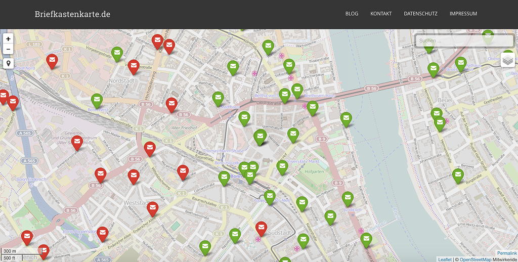
- [1] Danilo Bretschneider describes in detail in his blog how he has « built » his postbox map (this is very useful for beginners!)
- The Taglocator from marczoutendijk has been renamed as « OpenPoiMap » and has its own domain: openpoimap.org.
- The Ile-de-France in comics, « mapped with open source » (Englisch), more precisely on uMap with more than 70 locations from comics. (via Thevenon)
Open-Data
- « The scarcely discussed potential of Open-source data » is available on dbresearch.de (English).
- « Data for all » from Oliver Fuchs auf nzz.ch (English).
- Difference with OpenStreetMap? from the forum OpenAddressesUK.
- Nepal celebrated Open Data Day for the third time. This year’s Open Data Day was special because it had a special emphasis on open map data and was themed « Open Data and Map for Local Governance and Civic Participation ». The event was co-organized by Kathmandu Living Labs, a non profit tech company working to promote OpenStreetMap in developing countries.
Licenses
- Great Britain’s national mapping agency the Ordnance Survey has switched to OGL. They’ve also adopted a snazzy new logo, and in the process have gained a parody Twitter account. Read more here.
Software
- An Open Source Landsat Browser, Libra. from Astro Digital is now available
- Using RStudio as an interactive GIS with Leaflet from Kyle Walker
- Self-hosting Mapbox vector tiles on gis.stackexchange.com
- The Overpass API has its own developer mailing list. More information here.
- Google open sources a MapReduce framework for C/C++ from Derrick Harris
- Tommaso Urli describes in his blog, how to set up an OSRM server on Ubuntu 14.04.
- lat lon lat lon lat lon lat – Tom MacWright uses a table to show in which file formats or interfaces the first value is the longitude and the second the latitude, and in which ones it is the other way around.
- Tapping into OpenStreetMap Metadata via @developmentseed
Have you come across …
- … the master thesis from Kirchmayr-Novak “Bewertung der Datenqualität der OpenStreetMap als Datengrundlage für einen Verkehrsgraph mit Hilfe offener Daten und Software”? The abstract is in English. The title of the thesis: Evaluating the quality of OSM data as the basis for traffic graph data, with the help of open-source data and software »
- … TRAVIC, the transit visualisation client, developed by geOps in collaboration with the University of Freiburg?
- … the Veggiemap?
Other “geo” things
- Tech and data converge to create better maps about our shared worlds from Alex Howard
- The Android app from Mapillary has been thoroughly revised and is available in version 1.0.
- Google Now starts showing gas stations along your route.