weeklyOSM 288
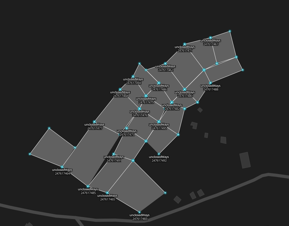
landuse=farmland), these were edited 2 years ago and does’t display on the map, Those bad geometries were detected by OSMLint-unclosedways [1] | Bild von Mapbox19/01/2016-25/01/2016
Mapping
In response to the terrorist attacks in Paris, Christian Quest has created an OpenEvacMap. The Hackathon was reported in “Le Monde”, one of the major French dailies under the title “A hackathon to increase security in Paris.” Additional press: LaTribune, RSLN. Follow the project on Twitter and github. Pictures of #necmergitur with a retweet of the Mayor of Paris Anne Hidalgo and the chief of the police of Paris.
Birmingham City Council is currently converting lots of streets into 20 mph zones. The local OSM community gets a list with all changed streets every Friday.
Ladislav Laska is looking for volunteers for testing the new development version of Merkaator (a desktop OSM editor like JOSM) at least for the Windows systems. Further on, he also needs support to publish an Apple OSX-Version.
The usage of
amenity=swimming_poolcan now be “discouraged” after the voting in OSM wiki (36 Yes, 5 No). The alternative tag isleisure=swimming_pool.Matthijs Melissen writes to the tagging mailing list, that his proposal for Aquatics centre has been rejected.
Matias Dahl extended his blogpost with a link to his interactive website which allows for exploring tags related the top 100 amenity tags.
Schools: Back to square one? A blog post in Mappa Mercia about UK Quarterly Projects.
Simon Poole tells about, what is in the pipeline for the next Vespucci release.
The french quality assurance tool Osmose now also covers Australia, Fiji, Palestine, Israel, Armenia, North and South Korea.
Pascal Neis writes in his blog on how to find suspicious changesets and how to observe an area in OSM.
Hillel Yakir has published four tutorial videos in Hebrew on Youtube, which gives an introduction to editing in OSM.
Users Hakuch has opened a proposal to “Remove suffixed name tag from wiki”.
name_1andalt_name_1should no longer be described in the wiki and thus not be a feature of iD editor any more. The voting runs until 2016-02-08.
Community
There is a discussion in the Austrian mailing-list about the indoor mapping of the west train station done by Mentz workers.
Ian Dees requests for feedback regarding his project Show Me The Way, one way to do this is by filing Github issues.
BushmanK suggests that one would need an issue tracker (he named Github) for tagging discussions. The opinions of the commentators are ambivalent.
OpenStreetMap Ireland reports about the collaboration with Blueprint Reprographics to scan out-of-copyright maps to update OSM data.
St. Lucia News Online reports about a mapathon which took place on 19. January on St. Lucia.
Mapbox developed a tool called OSM Comments. It is powered by an API that helps one search the changeset discussions and notes. It is open source, the source code and the documentation are available on github.
Imports
Edward Betts wants to match geographic objects in OSM with Wikidata items using a self written software.
The Dutch agency for road construction and traffic (NLStBV) made available actual planning data for the highway A20. The goal is to use the data to build a correct representation of the highway in OSM.
Events
- The organizing team of FOSSGIS reminds about the upcoming deadline of abstracts submission for this years edition and explains why everyone is welcome to present a talk.
Humanitarian OSM
Washington D.C. group wants to bring digital mapping to the people.
Blake Girardot will talk at FOSDEM in Brussels about the technical possibilities, the tools used and the success of the HOT-Missing Maps projects.
Lisa Nikolau talks about the Missing Maps Project. A map shows the work that still needs to be done in the world.
Maps
User MaKa announced that the WordPress OpenStreetMap Plugin is available in Spanish.
Valle published a video tutorial for advanced users on how to use BaseCamp to make a route for off-road biker fans.
switch2OSM
The locr GmbH, a supplier of geo-based marketing services, has choosen OpenStreetMap as data provider.
Sabarimala is a Hindu pilgrimage centre located at the Periyar Tiger Reserve in the Western Ghat mountain ranges of Pathanamthitta District in Kerala. The Motor Vehicles department of Government of Kerala have started using OpenStreetMap for depicting the Sabrimala Safe Zone Map.
Software
Software Version Release Date Comment OpenJUMP 1.9.0 2016-01-18 First new release since december 2014 OpenLayers 3.13.0 2016-01-20 68 changes and fixes OSRM Backend 4.9.1 2016-01-20 4 bugs fixed SQLite 3.10.2 2016-01-20 Bug fixes [1] OSMLint an open source suite of validators to understand the quality of OpenStreetMap data, and to identify common geometry and metadata problems at scale. The repository is here and this is the blog referring it. The developers are still adding more validator to detect other kind of errors in OpenStreetMap. Test it.
Dmytro Ovdiienko has released a program that is collecting data from the OSM wiki about all documented software and gives an output of an OSM Software Catalog.
Programming
By releasing version 1.7.5-idio.intel.lawyers, iD Editor has changed its license from WTFPL (Do What The Fuck You Want Public License) to ISC license (similar to BSD license). iD developers integrated code from Intel but Intel lawyers did not want to publish the code unter WTFPL.
Iván Sánchez Ortega describes all of what annoys him as the maintainer of Leaflet.
Users Malenki compares the memory requirements of different file formats for OSM data using Bulgaria as an example.
Did you know …
… the ten things you need to know about OSM. automatic translation.
… the site, on which every OSM developer has waited in vain for 10 years?
… the HOT Membership Code?
… Graph Hopper can also be used for visualization/analysis of correlations in major road networks? Keyword Shortest Path tree and MOSPF.
… a training module for newbies in OSM?
Other “geo” things
Effie Seiberg’s antique map cake became very popular. (52 retweets and 164 likes. ;-)
Mia Heikkilä in Eura (Finland) took pictures of a rare optical phenomenon which caused a city’s streets to be mapped in the sky. An explanation you can find on slate.com.
Locata Corporation developed in collaboration with NASA a ground based GPS . Such a network would be able to supplement the satellite-based GPS navigation and revolutionize. Accurate navigation in urban canyons or in the mountains, cm-accurate navigation even indoor GPS navigation in large buildings could be reality.
Unmanned Aerial Vehicle (UAV) visited Windsor Castle, UK; Cologne Cathedral, Germany and Christo Redentor in Rio de Janeiro, Brasil.
Upcoming Events
| Where | What | When | Country |
|---|---|---|---|
| Graz | Stammtisch | 25/01/2016 |  |
| Rennes | Rencontres mensuelles | 25/01/2016 |  |
| Colorado | Colorado State University Mapathon, Fort Collins | 27/01/2016 |  |
| Urspring | Stammtisch Ulmer Alb | 28/01/2016 |  |
| Paris | Rencontres mensuelles | 28/01/2016 | |
| WikiProject_Taiwan/state/新竹市 | HsinChu meetup #2 | 29/01/2016 |  |
| Brussels | FOSDEM Conference | 30/01/2016-31/01/2016 |  |
| Toronto | Mappy Hour | 01/02/2016 |  |
| Charlottetown | Learn to OpenStreetMap | 04/02/2016 | |
| Moscow | Schemotechnica | 06/02/2016 |  |
| Berlin | Hack Weekend | 06/02/2016-07/02/2016 | |
| Lyon | Rencontre mensuelle mappeurs | 09/02/2016 | |
| Salt Lake City | Geobeers | 09/02/2016 | |
| Cebu | Bogo OSM Workshop by French Red Cross, Bogo City | 10/02/2016-12/02/2016 |  |
| Wien | 54. Wiener Stammtisch | 11/02/2016 | |
| Paris | Mapathon Missing Maps | 11/02/2016 | |
| Derby | Derby | 16/02/2016 |  |
This weeklyOSM was produced by Laura Barroso, Nakaner, Peda, rogehm, Rub21, Ziltoidium, derFred, escada, jinalfoflia, malenki, mgehling, stephan75, wambacher, widedangel.
We welcome link suggestions for the next issue via this form and look forward to your contributions.
Leave a reply