weeklyOSM 297
22/03/2016-28/03/2016
Mapping
Lindsey Jacks writes about her work on the new field papers interface (we reported on earlier this month) done during her internship at Stamen Design.
Jonathan blogs about the road network of Rwanda and its bad, strange and western based classification.
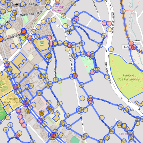
Rodrigo Rega explains how he uses Overpass API to query for streets in Lugo, Spain, that don’t have a
nametag.Camilla Mahon explains how Mapbox uses server statistics to decide which parts of the world need new satellite imagery most.
Citylab reported about the effort Stamen, their partner company has tried on behalf of their customers to replace unwanted paths from OSM (meaning highway=path by highway=social_path). The paths however soon reappeared in OSM. The report led to a discussion on the mailing lists talk-us and tagging and in the German Forum. A related proposal by Alan McConchie for this tag exists, but received little positive feedback.
On the OSM Colombia blog a report(Spanish) of mapping activities from the recent Mapathon in the region of La Guajira, Colombia. The resulting datasets can be downloaded from the Humanitarian Data Exchange.
Community
The OpenCage Data Blog publishes an interview with the lead developer of Traccar, an open source GPS tracking platform.
Marin Kaltani is trying to grow the OSM community in Albania by promoting OSM at the forthcoming Open Source Conference in Tirana. Recently an event was held focusing on editing with JOSM. More details in Albanian on the Facebook OSM Albania page.
Events
On the 6th of April there is a Mapping Happy Hour in Mexico City where the results of the import of the National Geostatistical Framework INEGI(Mexico) will be presented. Event details are here.
The US SotM conference will be held in Seattle from the 23rd to the 25th of July.
On May 7th there will be a Mapping Party held simultaneously in 3 different cities (Dar es Salaam, London & Vilnius). This is part of Crowd2Map Tanzania and the Open 17 Challenge. All three locations will be connected by a videoconference.
Humanitarian OSM
Dale Kunce shares his experience of field mapping for three weeks in areas of Liberia, Sierra Leone, and Guinea in his OSM diary. This Missing maps project is planning on training over 200 volunteers to learn how to map in OSM, mapping approximately 6 thousand villages over an area roughly the size of West Virginia or Switzerland.
Missing Maps provides a task for Damascus, Syria to assist the humanitarian organizations in this region.
Maps
Christopher Möller of webkid explains how they used Mapbox GL to generate a vector based and interactive map of cycleways in Berlin.
Moritz explains how he creates great interactive maps with OSMBuildings, e.g. the one of Berlin.
Thinking about your next vacation? Here are OSM maps for Crete available in Garmin formats ( Basecamp and Mapsource ).
Mapzen describes their new elevation tilesets, how they were created, which data sources were involved and what has to be kept in mind while creating such tiles.
To keep track of events in San Francisco you can use the daily updated map sfwat2do.com.
Open Data
- OpenStreetMap got a brief mention in the British Parliament at a Westminster Hall debate (not a law-making forum; just a discussion one) as a provider of road data for satellite navigation systems. More interestingly Claire Perry (representing the government) seemed to suggest that more OS Open Data will be on the way - “… later this year. It will include information such as road widths, traffic calming measures, and height and weight restrictions, which could then be linked to other public sector data sets, such as planned road works and cycle paths”.
Licences
- Due to plans to reform European copyright law, the EU wishes to hear the views (translated from German) of citizens concerned about the effects of a Google Tax and possible impacts to Freedom of panorama.
Software
Gnome 3.20 was released, this release allows the user to edit OpenStreetMap data.
Dennis Nienhüser writes about his progress in making use of OSM vector tiles in KDE Marble.
OsmAnd 2.3 has been released, an important new feature of this version is the OsmAnd Live Beta functionality.
Programming
Andy Allan writes about his use of the Atom editor, including its syntax highlighting support for Carto files.
Alex Bulankou explains how to host OpenStreetMap services in Azure.
Releases
- | Software | Version | Release Date | Comment | | — | — | — | — | | GeoServer | 2.8.3 | 2016-01-26 | Fixed 25 bugs, 4 enhancements | | PostGIS | 2.2.2 | 2016-03-22 | As befits a patch release, the focus is on bugs and breakages. | | Mapillary for iOS | 4.2.0 | 2016-03-24 | New Viewer and appropriate adjustments in the GUI | | QMapShack Linux | 1.6.1 | 2016-03-24 | - | | QGIS | 2.14.1 | 2016-03-25 | - | | QMapShack Mac | 1.6.1 | 2016-03-25 | - | | Locus Map Free | 3.16.1 | 2016-03-27 | Bugfix version |
Other “geo” things
Andy Woodruff calculated where you will arrive, if you start off the coast of the different continents and go straight over the ocean and visualized that on a world map.
Using Google Maps might lead you to demolish the wrong house.
CartoDB’s Muthukumar Kumar explains in an interview what it means to be a cartographer in the age of Google Maps.
The TU Delft is offering a PhD studentship, that focuses on the generalisation of 3D city models.
Steve Coast is now working for What3Words. Steve writes in his blog about the company, that it implements a proprietary, non-free system for addressing locations world wide by 3 words, the concept has come in for some criticism within the OSM community.
Geoawesomeness reports about Joshua Peters, who makes a living by drawing awesome maps.
Upcoming Events
| Where | What | When | Country |
|---|---|---|---|
| San Francisco | AAG Mapathon | 03/31/2016-04/01/2016 |  |
| Bordeaux | Missing Maps mapathon | 03/31/2016 |  |
| Essen | Stammtisch | 04/01/2016 |  |
| Sankt Gallen | Mapping Party following AGM | 04/02/2016 |  |
| Sankt Gallen | 2016 SOSM Annual General Meeting | 04/02/2016 | |
| Brasília | Encontro OSM Brasília | 04/03/2016 |  |
| Budapest | OpenStreetMap Meetup Budapest | 04/04/2016 |  |
| Buenos Aires | FOSS4G Argentina | 04/05/2016-04/09/2016 |  |
| Paris | Missing Maps mapathon | 04/07/2016 | |
| Numazu | ラブライブ!サンシャインin沼津市マッピングパーティー(Code for Numazu 第四回)) | 04/09/2016 |  |
| Lyon | Rencontre mensuelle mappeurs | 04/12/2016 | |
| Leoben | Stammtisch Obersteiermark | 04/14/2016 |  |
| Moscow | Schemo.hack 03 Hack Weekend | 04/16/2016-04/17/2016 |  |
| Kyoto | 京都世界遺産マッピングパーティ:第13回 特別編 延暦寺(西塔、横川) | 04/16/2016 | |
| Nottingham | Nottingham | 04/19/2016 |  |
| Santiago | International Space Apps Challenge | 04/22/2016-04/24/2016 |  |
| Berlin | Hack Weekend | 04/30/2016-05/01/2016 | |
| Clermont-Ferrand | State of the Map France 2016 | 05/20/2016-05/22/2016 | |
| Milano | State of the Map Italy 2016 | 05/20/2016-05/22/2016 |  |
| Brno | State of the Map CZ+SK 2016 | 05/21/2016 |  |
| Salzburg | FOSSGIS 2016 | 07/04/2016-07/06/2016 | |
| Rostock | OSM Stammtisch Rostock | 07/05/2016 | |
| Salzburg | AGIT 2016 | 07/06/2016-07/08/2016 | |
| Stuttgart | Stammtisch | 07/06/2016 | |
| München | Stammtisch München | 07/12/2016 | |
| Landshut | Landshut Stammtisch | 07/12/2016 | |
| Berlin | 97. Berlin-Brandenburg Stammtisch | 07/14/2016 | |
| Lüneburg | Mappertreffen Lüneburg | 07/19/2016 | |
| Nottingham | Nottingham | 07/19/2016 | |
| Seattle | State of The Map US 2016 | 07/23/2016-07/25/2016 | |
| Tokio | State of The Map Japan 2016 | 08/06/2016 | |
| Bonn | ‘’’FOSS4G 2016 Code Sprint’’' | 08/20/2016-08/22/2016 | |
| Bonn | ‘’’Workshops at FOSS4G 2016’’' | 08/22/2016-08/23/2016 | |
| Bonn | ‘’’FOSS4G 2016’’' | 08/24/2016-08/26/2016 | |
| Bonn | ‘’’FOSS4G 2016 Code Sprint Part II’’' | 08/27/2016-08/28/2016 | |
| Brussels | ‘’’State of the Map 2016’’' | 09/23/2016-09/26/2016 |  |
This weeklyOSM was produced by Laura Barroso, MatthiasMatthias, Nakaner, Peda, rogehm, TheFive, derFred, jinalfoflia, mgehling, seumas.
We welcome link suggestions for the next issue via this form and look forward to your contributions.
Leave a reply