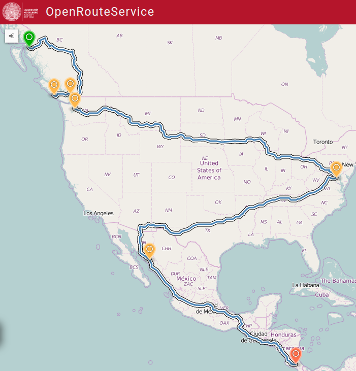
Route from Prince Rupert to San José via Washington with OpenRouteService ¹ | OpenRouteService is going Global - including the Americas
26/07/2016-01/08/2016
Mapping
Portable OpenStreetMap (POSM) aims to provide an offline workflow for mapping by integrating with OpenMapKit, FieldPapers, JOSM and others. It enables volunteers to bring OSM data into the field on very small servers that host their own wireless local area network, allowing editing to occur without any access to the Internet at all.
User geocodec compares the current indoor mapping of the Olympic venues in Rio de Janeiro in OSM and Google.
The Osmose-QA tool is available with world wide coverage.(automatic translation)
Coleman McCormick explains how to map OpenStreetMap data with your own captured videos.
The Education 2.0 proposal in the wiki was rejected.
Community
Benutzer -karlos- thinks that there should be an OSM Go, similar to Pokemon Go, to gain new mappers. He has some basic ideas, but is seeking for further input and help.
Australia is moving north - Andy Mabbett asks what the impact of Australia’s plans to change national coordinates will be on OSM. A followup message has lots more detail.
Lars Ingebrigtsen considers closing the Gmane archive due to hackers and lawyers costing him much time. Gmane mirrors a large amount of OSM mailing lists, too.
As we reported in Issue 314, the Kickstarter campaign for a $99 “MapClub” started by Steve Coast was canceled. A blog post by Alex Mahrou talks about the reasons. Steve reacts to that post and the cancellation.
Katrin Humal published a post about Celine Jacquins (mapeadora) work on OpenStreetMap, HOT, Mapillary and her love for Open Data.
Martien Sch complains about a change a Mapbox employee made, which removed good, locally surveyed data to replace it with bad remote data. She is also not pleased with his answer on her changeset comment.(automatic translation)
The Spanish OSM community also wants to create a local chapter.
User marczoutendijk shares his learning from running the “Welcome-to-new-mappers” program - an initiative to help new mappers in The Netherlands get started. Having run the program for over a year, marczoutendijk explains why he will no longer continue the program.
Michal Migurski explains in his blog why we don’t need “craft mappers” any longer, and why we should surrender those duties to Mapzen, Facebook and the like. Apparently “Facebook’s efforts here are a quantum leap in seeing from a distance” (though incidentally in Thailand their efforts had to be completely reverted and significant problems have been identified with their edits in Egypt). It’s worth reading the full text, if only for Joost Schouppe’s excellent comments.
Imports
Chetan Gowda discovered a large amount of poor-quality mapping of streets in Egypt. The comments to his post suggest that this has been auto traced by Facebook.
Meg Drouhard at the University of Washington wants to import sidewalks in Seattle. The discussion continues over the talk-us, tagging and imports lists.
User schleuss compares building data across a few cities in the U.S and shows the impact of L.A. Building import project in making OSM data ‘building rich’.
OpenStreetMap Foundation
Andy Allan explains how to help and test contributions to the Operations Working Group’s work. The OpenStreetMap blog also calls for participants that want to help.
Events
State of the Map Japan is happening at Tokyo on August 6th.(automatic translation) The theme for this year is “relations” - fostering stronger partnerships between various users of the map. Participation is free of cost.
Humanitarian OSM
You would like to see MapSwipe in your language? Then translate the few items in the spreadsheet.
MSF (Medecins Sans Frontières) urgently needs data for teams in Kinshasa that are battling the yellow fever outbreak. The most recent tasks are #2043 and #2045.
Maps
Mateusz Konieczny compares OSM carto and other map styles with the aim to improve the style. Further comparisons are to follow.
[1] OpenRouteService, the first routing service based on OpenStreetMap, now provides routing services for North and South America including all the main routing profiles, e.g. for car, pedestrian, heavy vehicles, bikes - the latter with several options from MTB, road bike to safest bike route etc.
Anand Thakker has launched a new project. A promising approach: “A pipeline to simplify building a set of training data for aerial-imagery- and OpenStreetMap- based machine learning. The idea is to use OSM QA Tiles to generate “ground truth” images where each color represents some category derived from OSM features. Being map tiles, it’s then pretty easy to match these up with the desired input imagery.”
Marcos Dione explains how he’s automatically extracting the centerline of riverbanks.
Mapbox’ lawyer approaches the OSM2Vectortiles project. Following accusations regarding authorship of the project’s PBF files there now seems to be a problem with the BSD-licensed “MapBox Streets Style”.
Releases
| Software|Version|Release date| Comment|
| —— | ———– |—-|—-|
|Locus Map Free|3.18.5|2016-07-16|No more MapQuest maps, some improvements and many bug fixes|
|OSM Buildings|3.1.0|2016-07-27|3 changes and one fix|
|Mapillary Android|2.37|2016-07-28|Many extensions and some bug fixes|
|Mapillary iOS|4.4.8|2016-07-30|Crash using facebook, GPS bug fixed|
… MapGive, an initiative of the U.S. Department of State’s Humanitarian Information Unit, provides a step-by-step guide to help volunteers get started with mapping and contribute to humanitarian initiatives?
… want to explore the possibilities of OsmAnd on your travels? Matthias Grote from heise Download Team succinctly sums up the most important functions of this versatile OSM app.
.. Go Map for iOS? Matthijs Melissen shares his personal experience of how the mobile editor has minimized the chance of user errors and made mapping easy.
… the many approaches to include images in UMAP? Please attempt to read the whole thread. ;-)
OSM in the media
José Sierra (Levante el Marcantil Valenciano) reportsabout the education of geo experts in Valencia focused on “OSM / HOT”. (Automatic translation).
Other “geo” things
Troy Lambert explains how maps are used to share information in a visual and engaging manner.
Apparently Apple has opened a secret development office for Apple Maps in Berlin and recruited developers that were also based in Berlin for Here Maps.
Brian McClendon writes on Uber’s blog about the mapping efforts that Uber are making, including launching mapping cars on the roads of the U.S.
The UN OpenGIS Initiative is to identify and develop an Open Source GIS bundle that meets the requirements of UN operations. The logo contest invites the artistic minds in the community to develop the official logo of the UN OpenGIS initiative. Deadline - August 31st, 2016
Gonzalo Ciruelos tries to mathematically determines the roundness of countries with details of the dataset used, algorithm and the code implementation.


Leave a reply