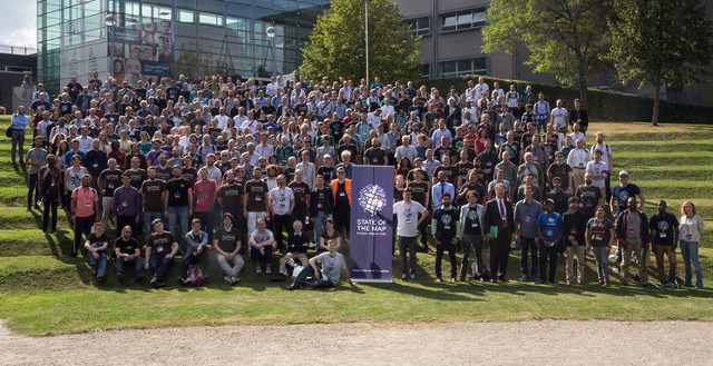
Group photo of this year’s participants @ SotM 2016 in Brussels ¹ | Picture by Tatiana van Campenhout CC-BY-SA 4.0
20/09/2016-26/09/2016
SotM 2016
During State of the Map in Brussels the 2016 funding drive was started, which shall finance the current cost of the OSMF. This is (not only) including the purchase and operation of the OSM servers. The funding goal is 70,000 Euro.
The videos from State of the Map 2016 are available online as full event streams. It will be split by talk shortly.
[1] At SotM the winner of the OSM awards were published (number of votes and given votes in brackets): Roland Olbricht (213/665), Lukas Martinelli and Manuel Roth (160/500), WeeklyOSM-Team (377/584), Martin Ždila (186/554), Pascal Neis (306/605), Frederik Ramm (186/576). More detailed results are on the voting platform, and there is a OSMF-Blog post.
You can find some pictures from the SotM Brussels with the tag sotm2016 on flickr.
At this year’s SotM there had been many wearers of a craftmapper t-shirt. The shirt was distributed at the conference as a reply to Michal Migurskis’s blog post (as reported here earlier). A sexist and racist comment on twitter did not match the reality but did lead to a small incident for Gregory Marler and Jorieke as our Code of Conduct volunteers (when they weren’t dealing with “vegetarian” salmon sandwiches and the effects of a wifi server reportedly catching fire).
Mapping
BushmanK thinks that the RFC status of proposals is not always respected and are not allowed to pass into the voting phase without processing all comments and questions.
On the Tagging mailing list, the tag for cenotaph is being discussed. It seems like none of these memorials had been added to OSM.
Warin has discovered an eight year old draft of a proposal to tag floodplains (natural=floodplain).
Abhishek of the Mapbox data team reports in his user diary about their work to improve the positional accuracy of the road network in Taiwan. (we reported earlier)
Community
Bryan Housel suggests in the Github repository of OpenStreetMap to introduce a code of conduct. In Bryan’s simultaneously added pull request there is a discussion about who would be the correct person to address for complaints.
About 100 students of the 4th grade of Santa Maria high school of Portugalete mapped the problematic points for people with reduced mobility and suggested more accessible routes so they can reach destinations, which are critical for them. Mapping Portugalete according to the report of this blog (automatic translation) is one of the many actions that were developed since 2014 by the program Ciudades Amigables (Friendly Cities).
Yahoo Finance reported, that Telenav on September 22 announced the availability of Open Street View, a free open - source platform, designed to accelerate the development of OSM. The platform includes free iOS and Android apps.
Pascal Neis experiments with a presentation of active mappers on a map.
Ben Discoe (in possibly the most polite “rant” ever written) commented on Michal Migurskis blogpost “OSM at Crossroads” (which was mentioned in weeklyOSM previously). The issue that he raises is somewhat different however - money!
Pratik Yadav asks for the reason to choose a particular username for OpenStreetMap. First answers can be found in the comments.
Imports
Spencer Gardner tries to find out how the lanes=* tag of oneway streets got “caculated” for streets in Massachusetts during the MassGIS Road Import.
The highway milestones became OpenData in France. The community discusses the tags, especially the value for the ref-tag
Dewi Sulistioningrum, an member of HOT, is interested in importing “infrastructure” (schools, mosques, hospitals etc.) and boundaries in a part of Indonesia.
OpenStreetMap Foundation
The Swiss OpenStreetMap Association is now a recognized local chapter (regional office) of OSMF. More local chapters exist in Italy and Iceland.
Humanitarian OSM
Biondi Sima of HOT Indonesia reported about three ways to DRR in Indonesia.
The project Healthsites.io that collects medical care centers for humanitarian purposes is now in a ß-status.
HOT reports about a week-long pre-assessment trip in Karamoja, Uganda.
Maps
The OpenCycleMap now supportscycleway: right = track / lane and cycleway: left = track / lane.
The Open Transport Net project with 14 European partners involved, opens and visualizes transport data in Europe. The city of Pilsen (Czech republic) visualized the traffic flow before and when major public works were taking place in the center of the city. The Pilsener citizens can see on the web which traffic issues they can expect.
Sven Geggus has deployed(automatic translation) the new German map style, a fork of OSM Carto with German/transliterated labels and “German” road colours, on openstreetmap.de.
Yvecai has created a new base layer for OpenSnowMap, which allows good contrast and good visibility for the display of ski slopes.
Open Data
GISuser reported about the crowdsourcing pilot project Statistics Canada, which was launched on October 17.
Software
Urbica has developed Galton an OSM-data and OSRM-engine based router that shows the areas for any point that can be reached in a fixed time. The source code is on Github. On her blog, the project is described more details.
Programming
On AWS there’s a new public and free digital elevation model which was created with Mapzen’s help out of different free data sources.
Tim Teulings reports about his work on libosmscout during the SommerCamp in Essen.
Lukas Martinelli searches for supporters on Kickstarter.com to develop a free style editor for JSON Styles for MapboxGL. The funding target was 4000 CHF and was reached during the SotM weekend.
Releases
| Software|Version|Release date|Comment|
| —— | ———– |—-|—-|
|Mapbox GL JS|v0.24.0|2016-09-19|Eleven new features & improvements, ten bugs fixed.|
|OsmAnd for iOS *|1.2.5|2016-09-19|Bugs fixed.|
|Geobuf|3.0.0|2016-09-20|One important breaking change and one bug fixed.|
|OsmAnd for Android *|2.4|2016-09-21|No actual info.|
|OsmAnd+ for Android *|2.4.6|2016-09-21|Car audio system integration, better routing, bugfixes.|
|Vespucci|0.9.8|2016-09-21|Many changes and improvements, please read relase info.|
|Mapillary Android *|2.40|2016-09-23| Login and signup with OpenStreetMap and Google, fixes for more stable browsing.|
|QGIS|2.16.3|2016-09-23|No infos|
|Gnome Maps|3.22.0|2016-09-24|Added, updated or fixed translations: Persian, Italian, Scottish Gaelic and Ukrainian.|
|Maperitive *|2.4.0|2016-09-25|No Info|
|Komoot Android *|var|2016-09-26|No info|
|Mapillary iOS *|4.4.14|2016-09-26| Login and signup with OpenStreetMap and Google, preserving EXIF tags.|
|Maps.me Android *|var|2016-09-26|GPS error fixed, new map data.|
|OpenStreetMap Carto Style|2.44.0|2016-09-26|Please read info.|
… the Taginfo report that indicates which tags are used a lot but do not have a wiki page to describe them?
… VROOM (Vehicle Routing Optimization Open-source Machine)? jcoupey provides an extension for OSMBC.
… the ‘Binary Bandits’ are stealing house numbers in Philadelphia, USA? Mysterious thieves steal the zeros and ones of the house numbers in Philadelphia. What drives the ‘Binary Bandits? And what does that mean for OSM? ;)
Other “geo” things
Holger Sparr of MacLife lists the best map apps for iPhone/iPad and explains their merits.
The web-enabled vehicles from Audi, BMW and Daimler probably will soon be a data supplier for Here.
The Spanish magazine NOSOLOSIG reported(automatic translation) in its latest edition that the “Instituto Panamericano de Geografía e Historia (IPGH)” commissioned a study on the quality of geodata in Latin-America.
Google explains how to create a custom map style for their vector tiles and therefore tries once more to close the gap with OpenStreetMap.


Leave a reply