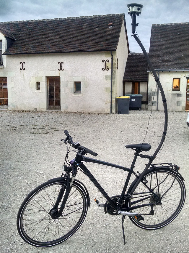
The new mapping bike of Stéphane Péneau ¹ | Image by Stéphane Péneau under CC-BY-SA
04/10/2016-10/10/2016
About us
This year’s OSM donation drive is still running. weeklyOSM says thank you to: Peter Karich (Graphhopper) for 1000 Euro, Florian Schenk (500 Euro), Viktar Shcherb (OsmAnd team) for 300 Euro, Andreas Geyer-Schulz, Markus Hallermann, Henri Geist and Julian Hollingbery each for 200 Euro and all the other donors to OSMF.
Mapping
Last week Mexico launched (automatic translation) their first cableway for public transportation: the ‘Mexicable’. The importance of the Mexicable is that it will be able to transport people from the poor neighborhoods of the suburbs of the capital. @federicomena asked (automatic translation) OSMers in Mexico to help map the stations. A week later the stations were mapped on OSM.
Ziltoidium asksin the German Forum, whether one can exert influence on bicycle routing by means of special tagging. (automatic translation)
Claudio Cossio reported about photomapping in Cuba on the occasion of the International Free Software Conference .
The weekly roundup by Krishna Nammala (Mapbox) about suspicious changes that were commented or reverted.
Community
ImreSamu has written a diary entry after reading Michal Migurski’s blog post that talked about robot mapping. Influenced by Sadya Nadella’s “laws of robotics” (which was of course influenced by Asimov), ImreSamu suggests what rules robot mappers should have to adhere to.
There’s discussion in the DE forum about the tone and etiquette used in discussions, including changeset comment discussions, with reference to the draft community code of conduct that has lain ignored in the wiki for some years (including a suggestion, perhaps not entirely serious, for a “Ministry of Truth Working Group”). There’s also been discussion of codes of conduct elsewhere, such as for OSM website and “Standard” map style development.
Guillaume is looking for documentation for uMap in English. As a basis for a new one, commentors suggestthe French version.
Christoph Hormann shares his views about the OSM Awards in his OSM diary.
[1] Stéphane Péneau presents his new mapping bike. Stephane explains the system here: Part1 and Part2
The Swiss SOSM updated their installation of uMap to the latest version.
On Spreadshirt.com you can order your T-shirt with the Craftmapper design as it was distributed at SotM.
OpenStreetMap Foundation
Skrill.com, a payment service you have to use if you use Flattr, owes the OSMF £ 500 and refuses to pay its debts.
Events
Harry Wood published a recap of this year’s SotM in the OSM blog.
Daniel and Victor reminds about this year’s SotM LatAm (Latin America) that takes place in São Paulo from 25 to 27 November.
In Tuscany (in the area of Alta Versilia) a hiking mapping party took placefrom September 30 until October 02.
Fredy Rivera called on October 10 for help to map two threatened villages around the volcano Cerro Machín (automatic translation) in Colombia. The mapping is already finished: Task1, Task2. It would be nice if experienced JOSM mappers could validate the data.
Maps
Anton of Transitwrote a very detailed and quite interesting explanation of how they autogenerate their transit maps for their supported cities worldwide.
Srikanth Lakshmanan reported that he has installed a language selection for 12 languages for India openstreetmap.in.
Open Data
DigitalGlobe delivered the latest satellite imagery after Hurricane Matthew’s catastrophe in Haiti under a CC BY license for humanitarian organizations such as HOT and the American Red Cross. Many of the images are also now available in OpenAerialMap, both for download and as map services.
Programming
Klokan Technologies (known for their OSM2VectorTiles) startedOSMNames, a new project that features basic place search functionality.
Mapzen published a new API called Libpostal to expand address data into component parts (like house number, street, city etc.).
Kepta, a GSoC intern, summarizes his contribution over the summer. He worked on building a lane editor for iD.
Spanish newspaper, Las Provincias reported in the group “Geovoluntariado” of Polytechnic University of Valencia who organized a mapathon to update the areas affected by hurricane Matthew.
The University of Gijon held an experimental workshop (automatic translation) within the framework of the INCUNA VIII Conference in which free use technologies are used to collect data of all kinds, visible and invisible, on buildings. The underlying intention (apart from practicing with OSM) is to extract useful information about the potential and use of public space.
Other “geo” things
One year after the historic agreement in the border conflicts between India and Bangladesh the Indian-Bangladeshi enclaves are still in Google Maps.
Wendy Lee from the San Francisco Chronicle reported from the Google Summit in California, where Jen Filzpatrick (Head of Google Maps) talks about the challenge of creating maps for self-driving cars. The competition like Mapillary is mentioned. The OSM-based Trulia website is also mentioned in relation to the limits of Google Maps’ timeliness.
Google has published Cartographer, a library running on ROS for building SLAM applications.


Leave a reply