weeklyOSM 327
18/10/2016-24/10/2016
Mapping
Martijn updated the imagery for his MapRoulette task to map cemeteries in Texas.
Martijn van Exel announced on the Talk-Ca mailing list, that colleagues in the Telenav mapping team are mapping turn restrictions in several Canadian cities using OpenStreetView and Mapillary as sources.
Cédric Briner asks, on the Talk-ch mailing list, about the procedure of tagging a walking bus route.
Multipolygon view of “OpenStreetMap-Inspector” has been turned off. The Areas view replaces it.
Community
jidanni tried to make OpenStreetMap’s conference advertising and donation drive banners less persistent, and briefly suggested that they be added to Adblock’s blocking list. He withdrew that request following much criticism.
UCC Ghana Youthmappers report about their success and their “snowball model” in teaching OSM at the University of Cape Coast.
Simon updated his Contributor Statistics and noticed a spike in new users as Maps.me’s edit feature appeared.
The Operations Working Group got access to the database of OSM Forum and moved it to an OSMF server on Saturday. During the move, HTTPS was deployed and all HTTP requests will be redirected to HTTPS. A subforum for Iceland has been created. OWG would like to hand over all forum-related aspects of the administration to a group of volunteers.
Roland Olbricht reports that the requests on the overpass API have now been logged from “74.9 percent of the total IPv4 /24 subnets of the entire world”. That’s not exactly three-quarters of the people on the planet, but it’s a lot, and from a lot of different places. A puzzling load peak on Oct 1st is explained by OSM getting well-known among Pokémon Go players. Expecting further growth, he suggests a second server for the API.
Jan Marsch, the person behind OSMBuildings, says on Twitter that it “Feels like Mapbox is eating up OSM. Project by project.“. Presumably it’s related to this blog post, although it’s unclear how one 3D building renderer can be threatened by the existence of another. Previously, Mapbox have introduced complementary tools before, like when To-Fix joined the existing Maproulette.
Imports
- James proposes an import of buildings and addresses in Ottawa, Canada, on the Imports mailing list, after his first attempt was reverted.
OpenStreetMap Foundation
The OSM blog officially announces about the Swiss SOSM being a local chapter of the OpenStreetMap Foundation. We say congratulations to SOSM!
Frederik Ramm, member of the board of FOSSGIS e.V., invites comments on Talk-de mailing list and on German forum if FOSSGIS e.V. should become an official local chapter of OSMF.

Events
- On October 15, the State of the Map West Africa took place. Nathalie summarizes her impression of the event.
Humanitarian OSM
Pierre Béland has published a website comparing aerial images showing the effect of Hurricane Matthew on Haiti. The “after” images were gathered by UAV and show the damage that the recent hurricane caused.
Major parts of Surabaya were inundated by floods this year. In order to minimize the impact, concerted efforts are undertaken. This calls for collectively updating the city’s base map data remotely, which is crucial to support the creation of an accurate contingency plan in the unfortunate case of disaster.
More discussion about the overlapping tasking managers in Haiti: An email by Rod Bera to the HOT mailing list explains why a second tasking manager for humanitarian mapping is required. According to him, the main problem is that tasks.hotosm.org is under the exclusive control of HOT. Blake Girardot denies that, and invites everyone to co-operate over a public Slack channel.
Maps
- NOSOLOSIG, a Spanish Geo-Blog, wrote a short blog (automatic translation) about Multimaps (automatic translation). Javier Jiménez Shaw, a Spanish software engineer who lives and works in Berlin, has combined many historical, topographic, satellite and road maps. Map enthusiasts can enjoy maps from seven countries, which are in overlay, synchronized or tangent. BTW a nice tutorial to explain the buttons on the right side.
switch2OSM
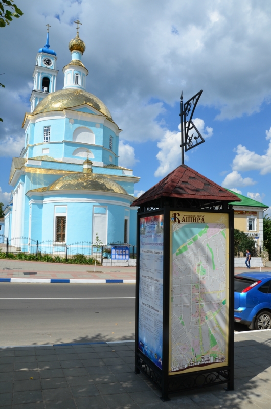
- The Russian city Kashira uses an OSM map for its new information point.
Open Data
- GoGeomatics Canada Magazine interviewed Ervin Ruci who has been collecting postal codes in Canada using crowdsourcing since 2005. In 2011, Canada Post sent him a cease and desist letter, and sued him and his company for copyright infringement. Canada Post discontinued court proceedings in 2012. Ervin Ruci talked about that at SotM 2014.
Software
With Christmas coming up in two months, OsmAnd can show as overlay Christmas markets, Christmas trees and other Christmas POIs.
GaiaGPS is now able to upload tracks directly to OSM.
Programming
User -karlos- reported again about his work on a 3D renderer.
Mapzen published Version 1.0 of their Tilelayer with worldwide elevation data.
User Marqqs introduces his new geocoder osmgeoref on a wiki page.
The new NVMe server “karm” has been the primary API instance since October 23, as announced by the OWG via Twitter. Its IO load has reduced from 90 percent to 3 percent since the change.
Releases
- | Software|Version|Release date|Comment|
| —— | ———– |—-|—-|
|Komoot iOS *|8.4.1|2016-10-18|Bug fix release|
|Magic Earth *|7.1.16.42|2016-10-18|Current speed, speed limits and speed camera warnings, improved management of alternative routes|
|Mapillary iOS *|4.4.18|2016-10-18|Added support for Ricoh Theta S, improved support for OSC v1 cameras and some more changes.|
|Mapzen Lost|2..1.1|2016-10-18|Fixes connection state not being updated until after callbacks invoked.|
|BRouter|1.4.7|2016-10-19|Added turncost and
oneway:bicycle=true, two bugs fixed.| |Vespucci|0.9.8r1204|2016-10-19|See release info.| |Mapillary Android *|3.0|2016-10-20|User interface and navigation is completely redesigned and rebuilt, support for older Android devices and some more “big changes”.| |OpenLayers|3.19.0|2016-10-21|Vector fills will rotate, freehand mode enhanced, Styles can now easily be cloned.| |QGIS|2.18.0|2016-10-21|No infos.| |Maps.me Android *|var|2016-10-24|Bug fixes and new map data.| |Maps.me iOS *|6.4.4|2016-10-24|Bug fixes and new map data.|
Provided by the OSM Software Watchlist.
(*) unfree software. See freesoftware.
Did you know …
… (rather: Do you still know) the online poll platform by Harald Hartmann? Sunk a bit into oblivion, it’s still ready for action.
… the Changeset Map by Mapbox to visualise a changeset? It offers different features to Achavi, and osmhv; try them all and see which you prefer.
… the imagery offset database? Nammala wrote a simple tutorial to make use of it in JOSM.
OSM in the media
Other “geo” things
Citylab writes about the importance of visualizing, which is one of the toughest challenges faced by the global cities. At Habitat3, the United Nations conference on housing and sustainable urban development, the Chennai flood map powered by OpenStreetMap and Mapbox tools was one of the five winners.
The “Jungle” in Calais is being cleared. It is only a matter of time before it will disappear from OSM as well.
Yahoo! News reports that in the vicinity of the Kremlin in Moscow, GPS signals are being interfered with.
Following a decision by the Supreme Court of Sweden, drones with cameras are seen as surveillance cameras and they are banned unless a special permit is applied for.
Alex Woodie from Datanami, summarizes a report about “The Here and Now of Big Geospatial Data”. The possible uses of spatial data, challenges characterized and different spatial databases are explained with examples.
Upcoming Events


This weeklyOSM was produced by Laura Barroso, Nakaner, Peda, rogehm, SomeoneElse, Spec80, SrrReal, YoViajo, derFred, jinalfoflia, kreuzschnabel, muramototomoya, wambacher.
We welcome link suggestions for the next issue via this form and look forward to your contributions.
Leave a reply