Regio OSM, a completeness checker for addresses now checks 1702 communities and many cities in Germany, one of the 11 countries where the tool can be used.
An interesting combination of OpenData and OSM to improve the OSM data of schools in the UK. One drawback is that a direct link exists only to iD. If iD is open, however, you can open JOSM from there. ;-)
Pascal Neis describes in a blog post his tools for QA in OSM
Find Suspicious OSM Changesets (Please note there are many possibilities to filter and also there are relevant links that provide further information.)
Arun Ganesh shows the significance of the wikidata=* tag by an example of the North Indian city of Manali. In his contribution, he also points to possibilities for improving OSM with further information via Wikidata, Wikimedia Commons, WikiVoyage and also points out information about using Wikidata with Mapbox tools.
The OSM Operations team announced a new feature on the main map page: Public GPS-Tracks.
Tom Pfeifer asks, how the quite modern form of cooperation, sharing of workspaces and equipment in the form of the coworking space should be tagged.
Chris uses AutoHotKey (Windows) and JOSM to optimize his mapping experience. He demonstrates this in a video, while tracing building outlines.
User rorym shows why it is useful not to make mechanical edits but “look at the area and look for other mistakes!”
User mmd shows in his blog how to use an overpass-turbo query to discover emojis in OSM worldwide. The serious background to problem-solving is to find “mixed-language” names. Tyr_asd offers a query with mapcss. User mmd wrote a code entry and requests for votings for regular expressions with full Unicode support in Overpass API.
Pnorman mentions in his blog post that Sarah Hoffmann (lonvia), Matthijs Melissen (math1985) and Bas Couwenberg (sebastic) have great merits in projects such as osm2pgsql, OpenStreetMap Carto.
The Nicaraguan community began searching for funds for the public transportation project in which they’re aiming to improve the accuracy bus frequency data in Managua.
Klaus Torsky reports(automatic translation) on the last FOSS4G in Germany. He links to an interviewwith Till Adams the brain behind the organisation of FOSS4G in Bonn.
Frederik Ramm invites people for the February hack weekend happening in Karlsruhe.
A mapping party took place in Tombuctu took place from 7th to 9th of January.
Humanitarian OSM
Kizito Makoye reports on the initiative of the Dar es Salaam City Administration, Tanzania, in the floodplains of poor regions such as Tandal drones. The Ramani-Huria project supports this by implementing the acquired data in OSM-based maps. This and other measures will improve the living conditions and the infrastructure in the slum areas.
Maps
On github the main developer of the Israel Hiking Mapsuggests that some of what that does might make sense on OpenStreetMap.org too. Various people explain how new functionality typically gets added - as an external implementation first, then (if it makes sense) at osm.org itself.
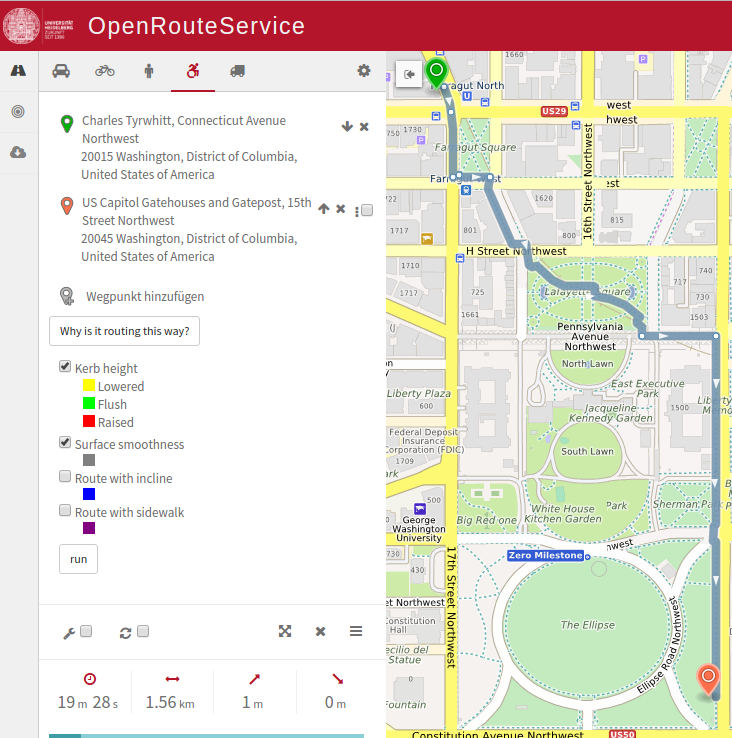
OpenRouteService now offers a unique feature for wheelchair routing. “Why is it routing this way?”. Consideration is given to kerb height, surface smoothness, route with incline and sidewalks.
Mapcontrib has reached version 1.0 and therefore published a first descriptive blog post.
On the CES 2017, Mapzen tried to attract customers with a 3D print.
Uber uses OpenStreetMap. Grant Slater expects Uber to contribute to OSM data.
Software
The Wikimedia help explains how to use the Wikidata ID to display the outline of OSM Objects in Wikimedia maps.
User Daniel writes a diary on how the latest release of Open Source Routing Machine (version 5.5) has made it easier to set up our own routing machine and shares some documentation related to it.
Releases
OpenStreetMap Routing Machine released version 5.5 which comes with some huge enhancements in guidance, tags, API and infrastructure.
… your next holiday destination? If yes, then the map with georeferenced images in Wikimedia Commons is ideal to inform oneself in advance.
… the GPS navigator uNav for Ubuntu smartphones? This OSM-based Navi-App is now available in version 0.64 for the Ubuntu Mobile Operating System (OTA-14).
OSM in the media
Tracy Staedter (Seeker) explained the maps of Geoff Boeing. He calls his visualization tool OSMnx (OSM + NetworkX). The tool can create the physical characteristics of the streets of each city in a black & white grid, showing impressive historical city developments. Boeing says, “The cards help change opinions by demonstrating to people that the density of a city is not necessarily bad.”
Other “geo” things
The Open Traffic Partnership (OTP) is an initiative in Manila, Philippines which aims to make use of anonymized GPS data to analyze traffic congestion. The partnership has led to an open source platform - OSM is represented by Mapzen - that enables developing countries to record and analyze traffic patterns. Alyssa Wright, President of the US OpenStreetMap Foundation, said: “The partnership seeks to improve the efficiency and effectiveness of global transport use and supply through open data and capacity expansion.”
This is how the Mercator Projection distorts the poles.
Treepedia, developed by MIT’s Senseable City Lab and World Economic Forum, provides a visualization of tree cover in 12 major cities including New York, Los Angeles and Paris.


Leave a reply