weeklyOSM 342
31/01/2017-06/02/2017
Mapping
Transifex is a tool that helps to localize the content and reach thousands of people. If you want to contribute in making learnOSM in your language, start translating using Transifex.
Jinal Foflia writes a post about getting started with OpenStreetMap, the importance of open data and why one should contribute to OpenStreetMap.
Voonosm asks in the forum how periodically occurring lakes could be mapped.
Volker Schmidt asks in the tagging mailing list about the best way to tag beef fattening stations.
Pavel Zbytovský would like to extend Simple Indoor Tagging, which he calls CoreIndoor. Sadly most of his extensions are based on wrong assumptions and misinterpretations about Simple Indoor Tagging, which documentation should be enhanced.
Joachim asks on the tagging mailing list for comments for an
amenity = snow_removal_stationwhere trucks can be freed from ice sheets.Unlike more enlightened places, England and Wales have a system of regulated access across otherwise private land. On the talk-gb mailing list Dave F mentions that the local government’s record of these might not match an actual path on the ground. The discussion then continues about which of these may be considered “correct”.
In the Swiss mailing list Hans Herzig asks about the tagging of gorges.
Community
Wa Mbedmi writes a post introducing OpenStreetMap Senegal and showcasing the importance of OpenStreetMap and its impact on the lives of the citizens.
Hernán De Angelis published a laudation of OpenStreetMap on his blog, which he has experienced through his Garmin.
The Nicaraguan OSM community invites participants to a workshop they organise about urban cycling in Managua.
User RichRico writes about the to-fix plugin and how that plugin coupled with the Tiger data layer can be used to align the misaligned roads in the US.
Sajjad Anwar from Mapbox writes about using OSMcha and OSM-compare to validate and analyse changes happening in OpenStreetMap. He urges the community to join the effort to keep OpenStreetMap the best map out there.
Due to progress in Belgium, Joost Schouppe queries whether there are examples of other governments to incorporate OSM into their data management.
Imports
- Mappers in West Midlands are going to import updated NAPTAN data (additional fields and improved coordinate accuracy). A discussion on Imports mailing list has not been started yet.
Events
The call for logo designs for the SOTM Latam 2017 taking place in Lima, Peru, is out.
The exact date of the State of the Map US 2017 has not been announced yet, only that it will take place in Boulder, Colorado in October. But the date of the international State of the Map conference in Aizuwakamatsu, Japan is known—18 to 20 August 2017.
Stefan Keller invites to the 8th Micro Mapping Party in Rapperswil, Switzerland on March 10th.
Humanitarian OSM
HOT launches their new micro grants program to enable the development of local OSM communities, to have access to equipment and increase skills, capacity and experience.
HOT announced that OpenAerialMap is officially no longer in beta status.
The Guardian reported about the number of girls in Tanzania who manage to escape genital mutilation, thanks to collaborative crowd-mapping efforts of places they can flee to and how to get there.
Maps
Wheelmap, the map for wheelchair-accessible places based on OSM, added support for 27 additional POI types.
GeekWire reports on Access Map research project at the University of Washington, which, among other things, provides routing for pedestrians and wheelchair users, using a mix of different data sources. The project (its import, its procedure and its tagging scheme) met with some people in the OSM community on rejection.
Open Data
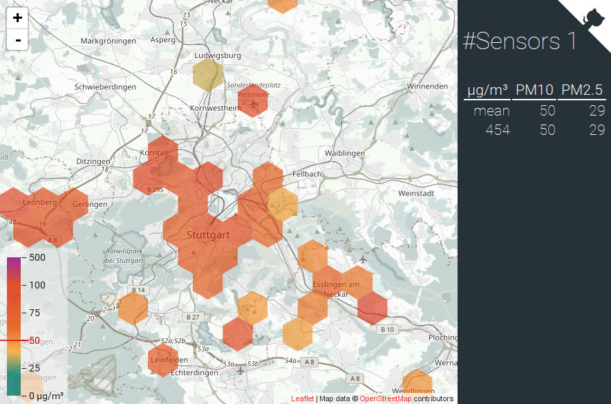
- [1] Stuttgart’s Citizen Science self-measure the particulates in their city. The project is also available in other areas, as you can see it on this map.
Software
- Osmand shares a gif showing how to quickly and efficiently search an address in the Android app.
Programming
Jochen Topf blogs about the new osmium-tool extract command that creates OSM data extracts faster than any other existing tool, while enabling several extracts on the same run.
Chris Loer reports how Mapbox improved label rendering using better line-breaking algorithms. This can be particularly tricky when displaying right-to-left languages.
The maximum size of changesets was restricted to 10,000 (down from 50,000). This should only affect editor developers.
Mariusz Rogowski complains on the dev mailing list about the quality of Nominatim and the project’s ability to attract new developers. Sarah and Frederik give detailed answers and, among other things, clarify why erroneous code is not included in the project.
Releases
- | Software|Version|Release date|Comment| | —— | ———– |—-|—-| |Magic Earth *|7.1.17.5|2017-01-31|Speed warning preferences, night colours, public transport now available in more cities.| |Vespucci|0.9.8|2017-01-31|Please read release info.| |JOSM|11526|2017-02-02|Hotfix of version 11514.| |Mapillary iOS *|4.6.4|2017-02-02|Fixed Crash.| |Maps.me iOS *|7.1.4|2017-02-02|Bugs fixed.| |iD|2.1.0|2017-02-04|Many changes, please read release info.|
Provided by the OSM Software Watchlist.
(*) unfree software. See: freesoftware.
Did you know …
- … “Trending Places in OSM” by Bhavya Chanra? The project analyzes the anonymous server logs, generates places that are most frequently visited and publishes them on Twitter.
Other “geo” things
ITECHPOST reports that the Philippine catastrophe management initiative “NOAH” ceased at the end of February. OpenStreetMap was very involved in this project last year, as this blog post shows.
The Guardian featured a small quiz by Alex Szabo-Haslam, in which one should identify cities by their waterways.
Upcoming Events
| Where | What | When | Country |
|---|---|---|---|
| Rennes | Atelier de découverte | 02/12/2017 |  |
| Rennes | Réunion mensuelle | 02/13/2017 | |
| Passau | Mappertreffen | 02/13/2017 |  |
| Zurich | Stammtisch Zürich | 02/13/2017 |  |
| Lyon | Rencontre mensuelle libre | 02/14/2017 | |
| Nantes | Rencontres mensuelles | 02/14/2017 | |
| Tokyo | Mappy Valentine’s Day!〜シビックマッピングについて語ろう〜 | 02/14/2017 |  |
| Karlsruhe | Stammtisch | 02/15/2017 | |
| Osaka | もくもくマッピング! #03 | 02/15/2017 | |
| Antwerp | Bar meetup | 02/16/2017 |  |
| Tokyo | 東京!街歩き!マッピングパーティ:第5回 六義園 | 02/18/2017 | |
| Karlsruhe | Hack Weekend | 02/18/2017-02/19/2017 | |
| Bonn | Bonner Stammtisch | 02/21/2017 | |
| Scotland | Edinburgh | 02/21/2017 |  |
| Derby | Derby Pub Meetup | 02/21/2017 | |
| Lüneburg | Mappertreffen Lüneburg | 02/21/2017 | |
| Brussels | Bar meetup | 02/21/2017 | |
| Montpellier | Rencontre mensuelle | 02/22/2017 | |
| Urspring | Stammtisch Ulmer Alb | 02/23/2017 | |
| Lübeck | Lübecker Mappertreffen | 02/23/2017 | |
| Zaragoza | Mapeado Colaborativo | 02/24/2017 |  |
| Cardiff | OpenDataCamp UK | 02/25/2017-02/26/2017 |  |
| Bremen | Bremer Mappertreffen | 02/27/2017 | |
| Graz | Stammtisch Graz | 02/27/2017 |  |
| Passau | FOSSGIS 2017 | 03/22/2017-03/25/2017 | |
| Avignon | State of the Map France 2017 | 06/02/2017-06/04/2017 | |
| Kampala | State of the Map Africa 2017 | 07/01/2017-07/03/2017 |  |
| Aizu-wakamatsu Shi | State of the Map 2017 | 08/18/2017-08/20/2017 | |
| Buenos Aires | FOSS4G+SOTM Argentina 2017 | 10/23/2017-10/28/2017 |  |
| Lima | State of the Map - LatAm 2017 | 11/29/2017-12/02/2017 |  |
This weeklyOSM was produced by Hakuch, Nakaner, Peda, Polyglot, rogehm, SeleneYang, derFred, jcoupey, jinalfoflia, keithonearth.
We welcome link suggestions for the next issue via this form and look forward to your contributions.
Leave a reply