weeklyOSM 343
07/02/2017-13/02/2017
Mapping
The German forum points out (automatic translation) that glass recycling containers for bottles and jars should be tagged as
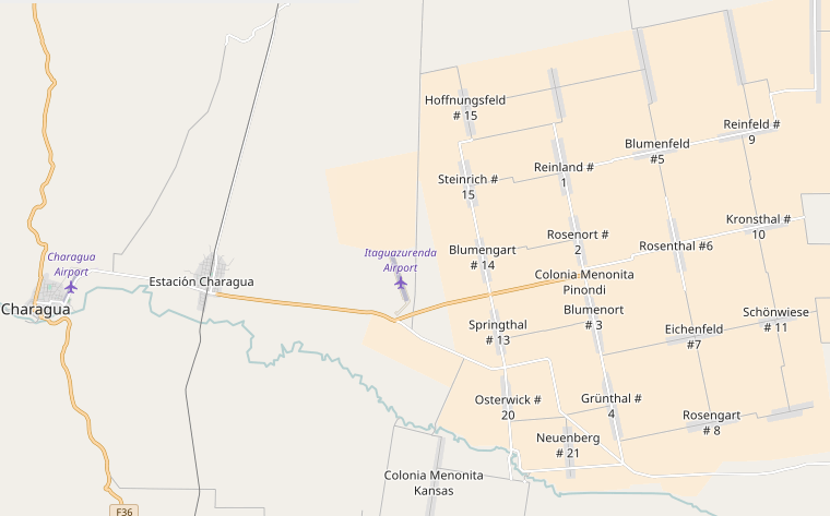
recycling:glass_bottles=yesonly, since the simpler keyrecycling:glass=*includes types of glass which are not accepted.[1] The Mennonite community of Colonia Pinondi in the Bolivian lowlands has started mapping its municipality in OSM with local knowledge. (Via OSM Cochabamba). We think it is a good example for Mennonite communities all over the world. ;-)
Martijn reports about his visit to an OSMTime event in Cluj, Romania. Beata Jancso from Telenav organises OSMTime, a mapping event, once a month.
Arun from the Mapbox data team exhibits the mapping of a street as an area. Specialized maps could get even better rendering results.
Jherome Miguel asks for comments on his suggestion of the extended tagging of power poles.
Joost Schouppe asks on the Tagging mailing list about how to tag knotted willows and search for English terms.
Editing a single node with Level0, built a transcontinental highway from Europe to Brazil.
Pascal Neis’ Suspicious Changesets now also displays rough-cut views of the content of suspicious changes. It does that using the Augmented Diffs of the Overpass API (Source: Twitter)

Community
Christian Bittner wrote an article on OSM in Israel and Palestine. He notes, among other things, that the OSM data and the maps derived from it are of particular importance in this political conflict (keyword: “ground truth”). Since it’s not an open access-publication, Christian shares PDFs upon request by email.
Ediyes shares her experience in mapping her hometown of Andahuaylas where she improved existing streets, added names, points of interest, parks, etc.
Peter Barth summarizes the results of the last Google Summer of Code and invites students to take part this year. If you are interested, visit the ideas page in the OSM wiki.
Martin Dittus (dekstop) presents the results of his research on how feedback on tasking manager affects the further activity of newcomers. Unfortunately, he does not disclose the rules by which he has classified the individual personal messages.
OpenStreetMap Foundation
- On the 12th February several OSMF operated services got new SSL certificates by Let’s Encrypt. Now you also get a valid certificate if you request foobar.osm.org instead of foobar.openstreetmap.org. (source: Chef repository of OWG)
Humanitarian OSM
The Irish MapLesotho group is again visiting Lesotho and there is a report about their work on Twitter too.
HOT reports about their new mapping projects that have started in Istanbul and Uganda and is increasingly focusing on crowdsourcing to make high-quality maps available for these regions.
LearnOSM has been updated with some interesting sections which include a guide for anyone to organise a Mapathon, tips aimed at new mappers which include an introduction to iD and tasking manager, and much more.
MakingMalariaHistory reports on a joint project to fight Malaria. Everyone with an OpenStreetMap account is asked to help.
Maps
- The LA Times published their code to generate web based maps using Mapzen’s Tangram.
Open Data
The Landsat program has a Twitter bot uploading images. Learn more about it.
OpenDataSoft published a post discussing the nature and representation of public transport data from heterogeneous sources. French open data providers are listed, and both static and dynamic feeds are aggregated on a single map.
Programming
Ilya Zverev from MAPS.ME submitted a pull request which adds MAPS.ME as an authentication provider for the OpenStreetMap website, i.e. users can log in with their MAPS.ME account.
Peter Liu from Mapbox, explains how he used satellite imagery and height data to generate an interactive 3D map using Three.js. He plans to make a similar demo with Unity next.
The behavior of osm2pgsql when no database is specified using the
-doption will change in the next release. Up to now, the default name isgis.
Releases
- | Software|Version|Release date|Comment| | —— | ———– |—-|—-| |PostGIS|2.3.2|2017-01-31|Bugfix release.| |iD|2.1.2|2017-02-07|Bugfix release.| |Mapillary iOS *|4.6.5|2017-02-07|Notification when entering an area that needs to be mapped. | |PostgreSQL|9.6.2|2017-02-09|This release contains a variety of fixes from 9.6.1.| |OpenLayers|4.0.0|2017-02-10|Enhancements and fixes from 107 pull requests since the previous release.| |Traccar Server|3.10|2017-02-11|No Info.| |Mapillary Android *|3.27|2017-02-13|Bugfix release.|
Provided by the OSM Software Watchlist.
(*) unfree software. See: freesoftware.
OSM in the media
Faultlines, black holes and glaciers: mapping uncharted territories, an interesting article by Lois Parshley where he talks about how certain areas in the world still remain a mystery. HOT is mentioned in the essay.
Here Be Dragons, a cartography essay by Lois Parshley. It comes with a theme of finding blank spaces in a well-mapped world. HOT is mentioned in the essay.
Other “geo” things
Increasing usage of smartphones as navigation aids appears (automatic translation) to impair sales for manufacturers of navigation systems.
Sebastian Meier used a laser cutter and moss to generate a nice map of Berlin.
Jurij Stare created a map of the light pollution in the world.
Mapbox joined 96 companies in filing the Brief of Technology Companies and other Businesses as Amicus Curiae in Support of Appellees in the Ninth Circuit Court of Appeals, opposing the Executive Order barring entry from and revoking visas from citizens of seven Muslim-majority countries.
Sebastian Meyer published a script for automatically transforming geojson boundaries into rectangles.
Upcoming Events
| Where | What | When | Country |
|---|---|---|---|
| Karlsruhe | Hack Weekend | 02/18/2017-02/19/2017 |  |
| Sucre | Charla sobre OSM para chicas del HackLab Sucre | 02/18/2017-02/19/2017 |  |
| Seattle | Mapping UW Sidewalks | 02/19/2017 |  |
| Bonn | Bonner Stammtisch | 02/21/2017 | |
| Scotland | Edinburgh | 02/21/2017 |  |
| Derby | Derby Pub Meetup | 02/21/2017 | |
| Lüneburg | Mappertreffen Lüneburg | 02/21/2017 | |
| Brussels | Bar meetup | 02/21/2017 |  |
| Viersen | OSM Stammtisch Viersen | 02/21/2017 | |
| Montpellier | Rencontre mensuelle | 02/22/2017 |  |
| Wyoming | Humanitarian Mapathon University of Wyoming, Laramie | 02/22/2017 | |
| Urspring | Stammtisch Ulmer Alb | 02/23/2017 | |
| Lübeck | Lübecker Mappertreffen | 02/23/2017 | |
| Paris | Rencontre mensuelle | 02/23/2017 | |
| Zaragoza | Mapeado Colaborativo | 02/24/2017 |  |
| Cardiff | OpenDataCamp UK | 02/25/2017-02/26/2017 |  |
| Bremen | Bremer Mappertreffen | 02/27/2017 | |
| Graz | Stammtisch Graz | 02/27/2017 |  |
| Stuttgart | Stuttgarter Stammtisch | 03/01/2017 | |
| Montreal | Les Mercredis cartographie | 03/01/2017 |  |
| Dresden | Stammtisch | 03/02/2017 | |
| Colorado Springs | Humanitarian Mapathon University of Northern Colorado, Greeley | 03/02/2017 | |
| Helsinki | Monthly Missing Maps mapathon at Finnish Red Cross HQ | 03/03/2017 |  |
| Lyon | Stand OSM Salon Primevère | 03/03/2017-03/05/2017 | |
| Minsk | byGIS Conference | 03/04/2017 |  |
| Graz | Map the Change @ Elevate | 03/04/2017 | |
| Dortmund | Stammtisch | 03/05/2017 | |
| Amagasaki | International Open Data Day 2017 in Amagasaki ~そのだ、マッパーになろう~ | 03/05/2017 |  |
| Rostock | Rostocker Treffen | 03/07/2017 | |
| Passau | FOSSGIS 2017 | 03/22/2017-03/25/2017 | |
| Avignon | State of the Map France 2017 | 06/02/2017-06/04/2017 | |
| Kampala | State of the Map Africa 2017 | 07/08/2017-07/10/2017 |  |
| Aizu-wakamatsu Shi | State of the Map 2017 | 08/18/2017-08/20/2017 | |
| Buenos Aires | FOSS4G+SOTM Argentina 2017 | 10/23/2017-10/28/2017 |  |
| Lima | State of the Map - LatAm 2017 | 11/29/2017-12/02/2017 |  |
This weeklyOSM was produced by Hakuch, Nakaner, Peda, Polyglot, Softgrow, Spec80, derFred, jinalfoflia, keithonearth, kreuzschnabel, vsandre.
We welcome link suggestions for the next issue via this form and look forward to your contributions.
Leave a reply