The Costa Rican community photomapped the trails in the natural forest reserve of Bosque del Niño in Poás volcano.
The Mexican OSM community proposes the use of the hashtag #CallesVioletas to visualize and map the public spaces. This is done by using an inclusive methodology that empowers citizens by generating participatory data from georeferenced photos.
Christoph Hormann cleans up defective multi-polygons and data garbage in the Antarctica region. He wonders why there are so many nodes created with the iD editor.
In his draft proposal, user dieterdreist suggests that the key emergency be supplemented by the collection of “dry riser inlet”.
Ever wondered why OSM hasn’t adopted a review procedure yet? Read the discussion on responding to vandalism thread in the Talk mailing list. Proponents and opponents share their thoughts.
The proposal for drying rooms for sports equipment is under way and Thilo Haug asks for comments.
Yuri Astrakhan suggests some features for editors to improve the usage of tags.
Tod Fitch thinks that the direction=* tag is used for too many unrelated conventions. The mailing list Tagging discussed some of them.
Charlie Loyd from Mapbox, writes a blog about the high-resolution images that are made available in India and can be used for mapping.
Community
User mueschel has published the visualisation service OSM Destination Signs, for relations of type destination_sign. See also the discussion (automatic translation) at the German forum.
An import of trees in the West Midlands of England that has mostly ignored the import guidelines has sparked some difficult discussions - some highly respected members of the GB community spoke up against it.
There was a discussion about Facebook’s proposed import (based on automatically recognising streets) on the “import” mailing list. It also continues to be discussed on the Thai forum.
OpenStreetMap Foundation
The minutes of the board meeting held on 21 February 2017 were published in the wiki of the Foundation. There was a discussion about the transparency of the Data Working Group among other working groups, the necessary profit from SotM and furthermore, the status of the Corporate Membership was presented.
Events
Simon Poole invites to the Annual General Meeting of the Swiss OpenStreetMap Association followed by a Mapping Party. This takes place on Saturday, April 8th at the University of Fribourg.
The enrollments for SotM France from 2nd to 4th June in Avignon are open.
Humanitarian OSM
On the HOT mailing list, Johnattan Rupire asks for help in dealing with the flood disaster in Peru which caused many casualties. This wiki page was created for more information.Here the recent tasks to work on:
Johnattan Rupire (@johnarupire) publishes an article in his blog about the importance of open data and participatory collaboration to save lives in time of emergencies and disasters.
Jochen Topf asks on the HOT mailing list for support in the repair of defective multi-polygons. Background and tools can be found in his website. The current status can be seen here.
Violaine from CartONG requests participation in a survey.
In Belgium you are invited to the second National Mapathon next Saturday, 25th of March, which will be organised at 8 different university campuses simultaneously. “More than 200 mappers will be trained by OpenStreetMap Belgium volunteers to work on MSF/Missing Maps tasks”, says Joost Schouppe.
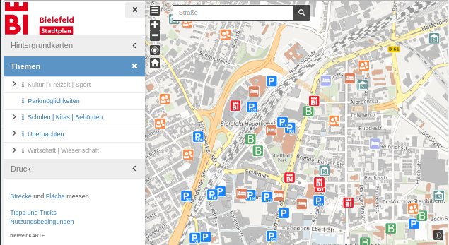
[1] The “Neue Westfälische” presents a new city map of Bielefeld.This map is based on OSM, cadastral and other sources. It is to be further expanded.
Frikart.no offers Garmin Maps with different Norwegian map styles.
Open Data
Christian Quest reported that the RTE (the French electricity network operator) published all network data (overground 45 kV to 400 kV, Underground, etc.) and declared it as open data.
Licences
Update: There is now an official common statement by The OpenStreetMap Foundation and Creative Commons for the compatibility of the CC-BY 4.0 with OSM. If you want to use sources that are under the CC-BY 4.0, you must obtain a waiver from the data provider as to 1) DRM restrictions and 2) format of attribution. Here’s a link to a template waiver form, as well as a link to template waiver forms for CC BY 2.0 and 3.0 data sources.
Programming
Ilya Zverev proposed a pull request that allows OSM users to communicate their email address to external programs via OSM verification.
Michael Spreng tests a new routing frontend at the swiss server. He asks for feedback.
Frederik Ramm suggests in the Geofabrik blog, what to do if osm2pgsql crashed on your servers due to the huge collective relation uploaded in Brazil a few days ago. (Reported in our last issue)
Mapbox checks the instructions of the navigation software OSRM. They use a tool that translates ASCII art of an intersection to a valid OpenStreetMap extract, then pushes the data for that scenario through the entire engine to make sure it behaves correctly.
Rob H. Warren is looking for volunteers regularly fetching planet dumps of OpenHistoricalMap as a backup.
Naoliv will distribute gifts to anyone who writes a notification tool, that will notify when there is a change in street name in a particular area.
Releases
| Software|Version|Release date|Comment|
| —— | ———– |—-|—-|
|Mapillary Android *|3.33|2017-03-14|Fix bug in distance mode, upgrade map box map for more stability.|
|Mapillary iOS *|4.6.9|2017-03-15|Added support for future feed items, some bugs fixed.|
|Locus Map Free *|3.22.2|2017-03-16|Bugfix release.|
|Maps 3D Pro *|4.1.4|2017-03-16|Many changes and fixes, please read release infos.|
|Maps.me Android *|var|2017-03-16|Hotel pages enhanced.|
|Naviki iOS *|3.56|2017-03-16|Integration of smart bike systems, bug fixes.|
|Traccar Client Android|4.1|2017-03-16|Fix some small issues.|
|Komoot Android *|var|2017-03-17|Minor enhancements.|
|Mapbox GL JS|v0.34.0|2017-03-17|Two new features and three bugfixes.|
|MapContrib|1.6|2017-03-17|Bug fixed.|
|Naviki Android *|3.56|2017-03-17|Integration of smart bike systems, connection to Bluetooth devices revised, bug fixes.|
|Maps.me iOS *|7.2.1|2017-03-19|Fixes for iOS 8.|
|PyOsmium|2.12.0|2017-03-20|Three extensions, documentation fixes and use actual libosmium.|
… the Android app StreetComplete? It allows you to easily find and add missing data in your environment.
Other “geo” things
A collection of community created maps of India sourced from different government websites is freely available to all Indians.
Boston schools ditch Mercator-based maps for Gall-Peters. (via TeachOSM). The world maps of Arno Peters provide a true to the surface projection and the distortions of the Mercator projection are avoided.
An article about Arun Ganesh’s involvement in Wikipedia and OpenStreetMap.


Leave a reply