The Bing Maps team announced in its blog the release of new satellite imagery (a total of 3.67 million km²) in Turkey, Greece and Argentina in cooperation with DigitalGlobe.
Nuno Caldeira describes how to improve road tagging using Mapillary horizontal imagery in JOSM.
The Zoo tagging has been extended with the tag zoo=wildlife_park. A description for Safari Park is to follow.
Community
GIScience of Universität Heidelberg supports the Crowdsourced Damage Assessment project at Stanford University by developing experiments to enable area based damage assessments and comparative damage rankings by volunteers.
The Colombian community operates their own tasking manager. The donations (see banner upper left) are going directly to Colombia.
Andrew Lester, a highly active mapper, expresses his thoughts after discussions on Telenav’s turn restrictions mapping in Canada.
In Senegal, a free of charge, ten days OpenStreetMap Mapping Training course has begun. It is organised within the framework of the Sunu Gox project “Our locality/community”, developed by the movement Y en Marre Senegal, in partnership with the Gret, “Les Libres Géographes”, OpenStreetMap Senegal and financed by the European Union. It aims to promote urban solidarity and citizenship in the peripheral districts of Dakar by strengthening citizen movements and grass-roots organizations in their capacity to act for the environment and the improvement of basic services through the production of diagnostic maps.
Pascal Neis has enabled an OAuth login for his HDYC page to protect privacy.
Imports
Drishtie Patel asks for feedback on the plans to import the road network in Thailand that are traced by an artificial intelligence.
Events
Maning Sambale announced that proposals for presentations can be submitted for the SotM Asia 2017 happening in Kathmandu, Nepal on September 23rd-24th.
Mikel Maron writes a Mapbox blog about the impressive work done by 3000 mappers in the mapping of 1.7 million buildings. These were mapped into OpenStreetMap to fight Malaria in Zambia, Botswana, Zimbabwe, Honduras and Guatemala.
The user upendrakarukonda, who works as a data analyst at Mapbox, summarizes the previous work of the project “eliminate malaria” and asks for more supporters to join this mapping effort.
Matthew Gibb (American Red Cross, HOT Community Member) shows the results of the mapping work after the cyclone Enawo.
Janet Chapman announced an one-hour webinar for Thursday, May 18th and asks to enroll for the same.
ArchitectsNewspaper writes about the open source project NYC space/time directory, which represents the development of the city of New York in the period from 1850 to 1950 by means of interactive maps.
Todd Robbins announces about him giving dataportals.org a facelift as the new maintainer of the page.
Licences
Dan Jacobson started started a discussion on licensing in the legaltalk mailing list.
Software
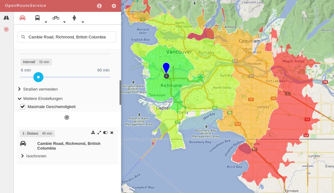
[1] OpenRouteService appears with a new API, new features (such as isochronous calculation) and an improved look.
Programming
Mapbox now provides a new layer with data about traffic congestion. The information is based on customer’s meta data and thus can be updated frequently in many places.
Jiaoyan Chen is pursuing research at the University of Heidelberg on how data from OSM and MapSwipe can be used to train neural networks with the objective of an automated detection of buildings on satellite images. First preliminary results are now available in a paper.
Releases
| Software|Version|Release date|Comment|
| —— | ———– |—-|—-|
|iOsMo|1.7|2017-04-24|Fixed issue with unhided screen keyboard on registration view, waypoints from group tracks now visible on map.|
|Mapillary Android *|3.54|2017-04-25|Better deletion of sequences after upload.|
|Komoot Android *|var|2017-04-28|No Infos.|
|Kurviger Free *|10.0.20|2017-04-28|The selection between the 3 route modes (fastest, curvy, extra curvy) has been moved to the route menu, avoiding ferries, highways, toll roads and smaller roads possible.|
|StreetComplete|0.8|2017-04-28| Add translations: Albanian, Danish, Japanese, Dutch, Polish, Russian, simplified Chinese, Swedish and Turkish, sending crash reports, bugfixes.|
|Locus Map Free *|3.23.2|2017-05-01|No infos.|
Mundodiario from Spain published an article about offline navigation apps and unsurprisingly mentions OSM.
Melanie Eckle talks about mapathons on the German radio station DLF Nova. Read more here in English.
SWR (German regional TV-Station) reported on a user Mapathon, at the University of Heidelberg, from minute 14:52 to 17:34.
“SciDevNet” reported on how a way out of violence in the suburbs of Tunis was found by using “mapping tools to influence planning decisions”.
Other “geo” things
The Norwegian village of Fossmork feels overrun(automatic translation) by tourists looking for Preikestolen rock via Google Maps – which is nearby but on the other side of the fjord.
In France, the police have introduced a tracking system for those in need. When an emergency number is dialed, the caller receives a text message with an HTML link. The caller then confirms the link and the geo-coordinates are sent to the rescue headquarters on a map.


Leave a reply