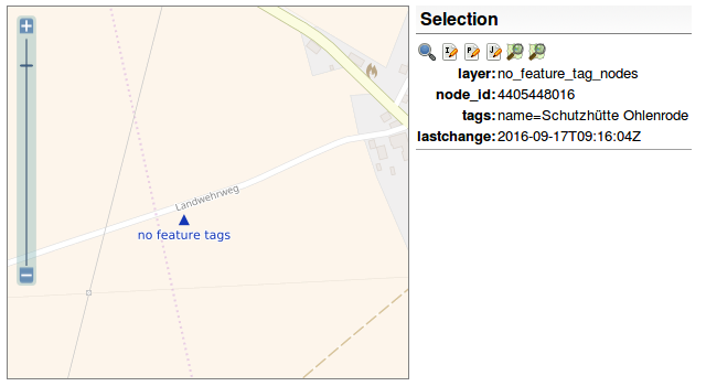
The OpenStreetMap Inspector now shows nodes and ways which do not have “important” tags. ¹ | data OpenStreetMap contributors, ODbL, image CC-BY-SA OpenStreetMap and Geofabrik
29/08/2017-04/09/2017
About us
We are always looking for people to help us improve our newsletter so it can get out faster, have more depth and coverage, and generally improve it for our readers, like you. Please join our team by contacting us now, it’s fun! ;-)
Mapping
[1] In the tagging view of the OpenStreetMap Inspector there is a new layer with tagging errors. The routing view now contains, once more, another error layer which shows ‘sources’ and ‘sinks’ of oneway roads which are either unreachable or have no return route.
The Flemish community in Belgium wishes to explicitly tag maxspeed on all highways. André Picard says this goes against existing usage in the country where a special relation of type default is used to provide information on a range of default values. He objects to the original wiki proposal page being marked as “abandoned”. Clifford Snow remarks that the documentation on the wiki is inconsistent and difficult to understand.
A discussion began on the Tagging mailing list around the usage of the tag shop=fashion as opposed to the tag shop=boutique considering that the latter has more uses.
The MapGive initiative of the U.S. Department of State provides the OSM community satellite image material of the region Ashgabat (Turkmenistan), which was recorded in the August 2017 (30 cm resolution).
Frederik Ramm started(automatic translation) a discussion on the German OSM Forum if we really need all boundary relations or if some of them should be deleted. As an example, he points to a segment of the River Rhine which belongs to 29 relations.
Sam Guilford from YouthMappers has published a small article about POSM and Mapeo.
Voting on the proposal Language Information will be open until 13th September. The proposal wants to introduce the tag language:<key> = <language code> which describes which language a tag <key> = * has.
iD has a new feature: “Review requested”. Pascal Neis writes in his blog post how to find these changesets and help the newcomer in his first steps in OSM, such as with links to wiki pages, tags, and map features, good practices, the OSM Forum or the page OSM help. Pascal forgot to mention the mailing lists. ;-)
Community
Dr. Steffano de Sabbato (Leicester University) asks for guidance to help interpret the mapping of London for his research. He also provides links to some previous preliminary studies.
Geospa_gal believes that there’s a need for more women to respond to the survey about gender bias in the OSM, and invites people to participate in order to have more accurate data about the gender situation in the community. Some people on Talk-US mailing list criticize the survey and the (desired) aims.
Gardster shares pictures (and videos) from the very well-attended 13th OSM Birthday party held by the Belarus community in Minsk on the 30th of August.
Joost Schouppe writes a diary entry highlighting the need of improving interaction between OSM and academic communities.
The minutes of the last OSMF board meeting on August 24 have been completed. The next public meeting will take place on September 21st 21:00 London time.
The minutes of the Local Chapters Congress at SotM have been published.
There will be elections to the board of the OpenStreetMap Foundation at end of 2017. Frederik Ramm explains what potential candidates should expect and tries to abandon some illusions about being a board member.
A meeting of the Engineering Working Group took place on August 29 and the minute is online. The topic was the end of this year’s Google Summer of Code.
Events
Edoardo Neerhut writes in the Mapillary Blog about the OSM ecosystem, OSMCha from Mapbox and about the AI assisted road tracing of Facebook in Thailand.
The call for papers for the SOTM Latam 2017 is still open! The conference will take place in Lima, Peru, from November 29th to December 2nd.
YouthMappers published their second quarter newsletter.
Maps
Stephan Bösch Plepelits, author of OpenStreetBrowserreported in his blog that the pop-ups on the map have been significantly improved. A permalink will be available for the map in the near future.
Mapbox announces a modified pricing in its blog. They rolled out pay-as-you-go pricing for their core products like maps, search, and navigation.
Programming
Frédéric Rodrigo published his findings on using a Redis database to query OSM objects and discusses performance relative to SQL queries on PostgreSQL. The experiments aim to explore ways of improving the heavy computations of the Osmose QA-tool.
Maripo Goda works on a JOSM plugin which warns mappers if they move a node over a large distance.
Releases
The new release of Mapbox Navigation SDK for iOS v0.7.0 comes with automatic day/night styles, other UI improvements, better compatibility with Amazon Polly, support for multiple legs, more aggressive location snapping, new localizations and much more.
Accurate maps of crops in both Germany and England have been produced using Remote sensing data from the ESA’s Sentinel-2 satellite. The English dataset is published under an open licence.
Thames Valley Records Centre (TVERC) are using non-open data on building age to create a model of potential bat roosting sites.
A nice article by Kartin Humai shows how to go on a “time travel” with Mapillary. ;-)
Stefano Cudini has a demo version of his open source ‘geo-social’ platform KeplerJs online. KeplerJs combines the features of social networks with geographical facts and uses OpenStreetMap among others.


Leave a reply