Michael Reichert aka Nakaner has written a proposal for an “expiration date” of the “Validity of Public Transport Route Relations”. Or at least a date by which the route relation should be looked at again, because changes in the schedules might affect the itineraries or the stops served
We reported previously on Yuri Astrakhan’s (in OSM, “nyuriks”) proposition to bring in line “wikidata” and “wikipedia” urls, and the discussion about the mechanical edits that he was doing. Yuri’s now created a “Quick Edit” tool to make mechanical edits in general easier. The consensus of the discussion is that this tool, like other similar ones, is governed by the Automated Edits Code of Conduct. The discussion on the talk mailing list is here.
The proposal Fire Hydrant Extension to extend and change the hydrant tagging has missed the required majority with 28 ‘yes’ and 21 ’no’ votes.
You can cast your vote on the proposal River Classification which wants to add the tag river=major/big/small for rivers. See also the discussion on the Tagging mailing list.
Mapping “dog droppings bag dispenser”? Not only in Germany. ;-) Alejandro Moreno asks on the Tagging mailing list how to tag a dog droppings bag dispenser with a trash bin.
Following complaints from local mappers, the DWG had to block a number of students from Carleton University in Ottawa due to problems with a student mapping project. There is also a discussion on Talk-Ca mailing list about this. There were a number of issues (including duplication), but the main one seemed to be that it was misunderstood that OSM was a set of live data - if something obviously incorrect is added there, it gets fixed, which made it difficult for students to find their individual submissions.
Bryan Housel accepted a pull request for the iD editor which adds a tagging preset for place=plot to the iD editor.
Christoph Hormann presents in his blog as a replacement for the name=* tag a concept in which only name:*=* is recorded and the boundary relations specify a formatting formula in the form of a tag, which language(s) should be rendered in which order, so that the usual local labeling is achieved.
Nakaner writes a longer article in his user blog why he rejected the Proposal Fire Hydrant Extension.
Contributor nammala posted an OSM diary entry describing the latest updates to “OSMCha”. OSMCha was originally written by Wille Marcel; see his diary for details of OSMCha’s new API.
On the talk mailing list, Dave Swarthout asks for the best practices for tagging oil fields - both the larger “concession” area as well as the actual infrastructure.
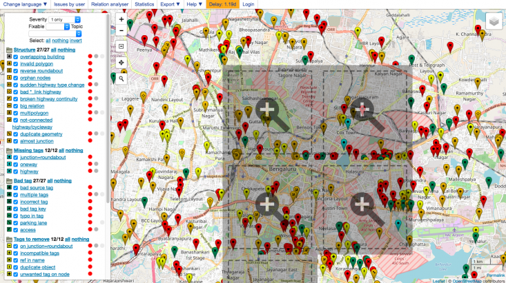
[1] The quality assurance tool Osmose now uses vector technology to display the markers (Source).
Shirini writes about a mini workshop using a TelegramBOT to translate strings for OpenStreetMap.org at Chennai
Community
Last week, first camps of Association Projet EOF “OSM, FreeGIS and opendata” program funded by OIF/DFEN got started in Togo and Niger and a one day event (mixing conference, hands on sessions and mapathon) in Benin, Burkina and Ivory Coast. Since 16-October, 10 similar camps of 5 days have been starting in Dakar, Bamako, Kayes, Ouagadougou, Abidjan, Bouaké, Niamey, Cotonou and Adjara/Porto Novo. To be followed on Twitter through #ActionOifProjetEOF.
Michelle Thong reports from her participation at the National Day of Civic Hacking in San Jose on 23rd September 2017. She thinks that Code for San Jose (the local Code for America group) could learn from OSM how to attract new contributors.
Geochicas, the OSM Latin American women community, launched a survey to learn about the gender gap in the OSM community. User «code elusive» mentions on Diversity-talk mailing list that the survey uses Google but asks for some personal details. You can find the survey written in EN, DE, ES, FR, PT, AL.
Contributor GOwin from Philippines, shares the new interesting initiative the local OSM community has come up with to engage, and expand the community of OpenStreetMap contributors in the country. The concept is that the local community will take care of the pizzas, all you need is mapathons, hacking events and most importantly, passion!
The San Jose Sidewalk Import (we reported earlier) attracted attention due to its poor quality. Sidewalks were uploaded although they have not been connected to the remaining network. Local mapper Minh, who is one of the primary mappers in the affected area and has mapped 42% of the sidewalks in San Jose by hand before the import started, replies to the mailing list saying he welcomes this import for a broader, long-term effort to improve OSM’s quality in the area.
Frederik Ramm starts a discussion on Talk-US mailing list how to deal with the many junk imports from NHD in future.
Events
At FOSDEM in February 2018 in Brussels, a yearly event attracting 8000 developers of Free Software, there will be a GeoSpatial room again. If you want to propose a talk, please do.
Miami’s Department of geography’s mapathon unites faculty and students to help provide aid to hurricane in Puerto Rico.
This year’s State of the Map CZ will be held at the Czech OpenAlt conference in Brno on 4th and 5th November.(automatic translation)
There will be talks from companies working with OSM data and a talk on the topics that the Czech OSM community is dealing with currently: hiking (cycle,horse,etc..) trails mapping, landuse and building tracking from official registers, photos for mapping support (PhotoDB) or upgrades to the national OSM portal osmap.cz.
Humanitarian OSM
Humanitarian OpenStreetMap Team is calling to help provide critical data in response to the Mexico Earthquakes, South Asia Floods, Caribbean Hurricanes and West Pacific Volcano threats.
OSM contributor Mapanauta writes a brief about Open Humanitarian Mapping in response of Mexico earthquakes.
… the possibility to quickly display a meaningful map with POIs and routes with geomob. de?(automatic translation) Examples: here and here and here.
OSM in the media
Government Tech writes about the importance of maps during disasters such as hurricane Irma, as they’re a “reliable visualization of areas that are likely to be changed by storms.”
Other “geo” things
As part of a deal with Parks Canada, Google is now showcasing Street View images of one of the remotest places on the planet - Quttinirpaaq National Park
Japan launched the fourth satellite for its regional QZSS (Quasi Zenith Satellite System). All four satellites are on geosynchronous orbits over the Asia-Oceania Region.
Lots of people (including CrunchBase) are reporting that SoftBank has invested $164 million in Mapbox, driven amongst other things by the growth in autonomous vehicles. Mapbox’s own blog reports it here.


Leave a reply