The editors deeply regret this, as the calendar is an essential source of information for our readers. We understand that a “quick hack” is not future-oriented and that it can stand in the way of further development and are now looking for someone who can come up with a technical solution for a regular publication of the dates in weeklyOSM. Unfortunately, transferring this information manually to weeklyOSM is not practically feasible.
Mapping
User velmyshanovnyi, who had been criticized for the use of the improvable JOSM plugin ScanAerial in Alaska, has started a discussion on the talk-US mailing list
How would you tag an amphitheatre, which is made of stairs? Or are these stairs, which are also used as an amphitheatre? This question got asked on Reddit.
Stephan Knauß has updated the Loose Ends map, which shows Asian pathways that end in nothingness and where aerial photos would be available to continue drawing. No polygon of the cover is now used anymore, but an algorithm decides whether high-resolution aerial images are available at the respective position. On the webpage, there is also a detailed explanation of what exactly is displayed. After a test phase in Thailand, the coverage has now been extended to other countries in Asia.
Community
Stewart writes in the talk-ca mailing list about a possible import initiated by the Statistics Canada - effectively, the Canadian Federal Government. This import comes with a goal of having all the Canadian buildings on OSM by 2020.
To begin working on the efforts, Mapbox is collaborating with StatCan in engaging the Canadian universities to participate in the Building Canada 2020 project by hosting mapathons during OSMGeoWeek (November 12-18, 2017).
The Italian community takes the first place in the total number of mailing list posts ladder. Some users (automatic translation) wonder if this record is good or if it signals a tendency of bikeshedding instead of more productive activity.
Last week, the conference on digital sustainability DINAcon was held in Bern for the first time this year. OpenStreetMap won the DINAcon award in the Open Source Hero category (https://wiki.openstreetmap.org/wiki/File:DINAcon_2017_award.jpg). Representing the community Michael Spreng, Stefan Keller and Simon Poole received the award.
After the 10 workshops of last week, the members of association “Projet EOF”, supported by “Organisation Internationale de la Francophonie” (OIF) have started with five “OSM, FreeGIS and opendata” workshops from 23rd October in Saint-Louis (Senegal), Lome (Togo) as well as Saint-Marc, Cap-Haitien and Port-au-Prince (Haiti) for 75 participants. Follow this on Twitter through #ActionOifProjetEOF.
Seppe Santens is “mapper of the month” for October 2017.
The Belgian Community just released the latest issue of their newsletter.
Michael writes to import mailing-list about the change in the Facebook’s wiki on AI-Assisted Road Tracing, to which Drishtie from Facebook replies about the change reflecting changes in the process.
OpenStreetMap Foundation
The next meeting of the OSMF Board of Directors took place on 26th October at 19:00 UTC on Mumble. Main topics are a model agreement on the use of the “State of the Map” brand and the Advisory Board.
Frederik Ramm has published the results of the OSMF survey to design a guideline for paid and organized editing.
Events
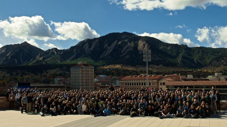
[1] State of the Map US took place in Boulder, Colorado last weekend.
Jordan Wirfs-Brock shared some of her sketchnotes on Twitter.
Humanitarian OSM
Christoph Hormann expresses on the Talk mailing list, his impressions, and feelings, which he has as a non-Hottie for Tasking Manager 3. It is about the use of the word mark OpenStreetMap. The discussion is ongoing.
Issue 13 of the HOT Newsletter has been published.
Version 3.0 of the HOT Tasking Manager was released. Read the changes here.
switch2OSM
The German Federal Agency for Cartography and Geodesy (BKG) uses OpenRouteService (ORS) with OSM data as its own routing service, including the geocoders and isochrone APIs from ORS. In addition, the ORS API has been extended by special functions, e.g. relevant to cycling.
The Austrian Mail and researchers from TU Graz develop a robot to deliver mail. The ORF (Austrian Broadcasting Corporation) reports(automatic translation) about it and mentions OpenStreetMap as a data source.
Software
Toursprung now offers a paid map editor called Printmaps to design printable maps. Output formats are PNG and layered PSD (Photoshop).
If your JOSM menu bar is gone after an upgrade to Mac OS High Sierra, you have to change “look and feel” in the JOSM preferences dialog (F12) from “Mac OS” to “Metal”. Other Java applications have the same bug. Oracle claims that it is a bug in Mac OS.
The CityZen App, which focuses on privacy, can now also edit OSM data
Programming
Mapbox’s iOS SDK v3.7.0 ensures maps for blindness or visual impairment which is fully compatible with the VoiceOver screen reader built into iOS.
The JOSM developers work on a stronger modularisation of the programme and declared some classes and methods which are relevant for plugins as deprecated. The affected plugins have to be modified until end of 2017.
Releases
OsmAnd 2.8 (for Android) has been released. There are various improvements concerning map markers, favorites and distance measuring.
….OSM-vis? Interesting is the Comparison of the different publication dates of tags in the wiki and in the database by Martin Raifer and Franz-Benjamin Mocnik.
Other “geo” things
The mapathon by the OSM Philippines community featured a rather spectacular wall of monitors showing the maps and edits in realtime
GeoHipster is calling for maps for contributions for the 2018 GeoHipster calendar.
There’s been speculation that the reason that Mapbox paused updates to customers was due to the Softbank investment reported last week. There’s been no further comment from Mapbox at this time.
This service will be discontinued on 01.01.2018, if there is no technical solution for a regular publication of the dates in weeklyOSM. If you want to help/can help to maintain the service, contact us on blog [at] openstreetmap [dot] de.


Leave a reply