SunCobalt has written a parser in Python for the wiki calendar based on the new hCalendar format. The parser has already been successfully integrated into OSMBC so that the OpenStreetMap calendar will remain a part of WeeklyOSM even after 2017-12-31. Big thanks to Thomas on behalf of our readers as well.
Mapping
An enthusiastic tweet from Pascal Neis celebrating the reaching of one million members who contributed at least one changeset to OSM. The responses suggest that figure is a little high if one takes into account unsuccessful edits (empty changesets), and that the actual mark of one million data contributors will be passed in the next couple of months.
Antoine Riche reportsabout a procurement market to add and maintain bike-related data in OSM around Paris, France. A mapper has been hired and the ongoing work is tracked using #CartoVeloIDF. Carto’Cité will handle connections with the OSM and biking communities. In the light of the recent discussions on paid mapping, they make a point of documenting the whole process on the wiki.
Strava has updated its heatmap and written an article about the update. Evaluating three trillion latitude/longitude points (10 terabytes of raw data), the heatmap can also be used in iD and JOSM.
User ypid reported in his blog that there are nearly 1 million recorded opening hours in OSM.
Community
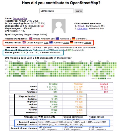
[1] Pascal Neis’ tool “How did you contribute to #OpenStreetMap?” was updated. Pascal marked the changes in the tweet image. A blog post has been announced, but not yet published.
Since October 23rd, members of Project EOF, supported by OIF, carried out seven “OSM, FreeGIS and open data” workshops in Niamey (Niger), Ouagadougou (Burkina-Faso), Saint-Louis (Senegal), Lomé (Togo) as well as Saint-Marc, Cap-Haitien and Port-au-Prince (Haiti) and also 15 one-day actions mixing conferences, technical sessions and mapathons. Follow this on Twitter through #ActionOifProjetEOF.
The OSM community was recently awarded at the DINACon conference on digital sustainability. The announcement includes the list of this year’s OSM Awards, awarded at SotM 2017.
The Nigerian OpenStreetMap community now has a Twitter account.
Imports
After Paris and Nice, Vincent Frison plans to import building heights in Montpellier, France. He created a dedicated wiki page to document the process, based on different ground models and open data provided by the city.
OpenStreetMap Foundation
The provisional minutes of the meeting of the Licensing Working Group of OSMF on November 2nd are online. Main topics are the directive on the use of the “State of the Map” trademark and data protection issues in connection with the new EU Data Protection Basic Regulation.
Events
The State of the Map LatAm 2017 program is online! You can find out more about the activities here.
Humanitarian OSM
The International Federation of Red Cross (IFRC) and Red Crescent Societies joined Missing Maps. It aims not only to encourage engagement and support in mapping activities but also improve data literacy and skills across the IFRC.
The IFRC and the International School of Geneva hosted a Missing Maps event for secondary (high) school students.
User MKnight writes(automatic translation) a diary post about the user interface of Tasking Manager version 3.
Maps
Sven Geggus, maintainer of the German fork of OSM Carto reports about its current state and the recent difficulties.
The developers of OSM Carto discuss a proposal to increase the minimum zoom level of some features whose rendering currently starts on zoom levels 5 to 7. Propositions of different rendering based on density/realities of different countries are rejected because of limits of the rendering tool.
Software
User baditaflorin wrote a diary entry on how to create a translation file to convert shapefiles to OSM data. Furthermore, Cygnus is used for conflation.
Programming
Bryan Housel merged a pull request bringing OpenStreetCam imagery into the iD editor.
Carto users ask more and more often to quickly render large geographic datasets with the PostGIS-Mapnik toolchain. Paul Ramsey provides an accurate performance analysis of the various processing steps, alongside with available optimisations and future development plans.
User Convergence presented a new 3D renderer on Reddit with New York as an example.
Steve tweets about the free WiFi finder that he built using Mapbox’s iOS store locator and his city Alberta, Canada’s open data.
Jinal Foflia tweeted a picture at the San Francisco International Airport that is using Mapbox maps with OpenStreetMap data.
The Guardian newspaper uses OpenStreetMap data to illustrate the effects of rises in global sea level on various major cities around the world.
Gerry McGovern writes about navigation-induced traffic jams in England, and more broadly about the consequences of digitalisation on modern society.
TechCrunch reported the acquisition of MapData, a neural network-based mapping startup by Mapbox. An augmented reality-based map SDK should be coming soon next year.
An article in “The Conversation”, an online magazine, discusses the importance of ‘openness’ for the digital economy; and mentions OpenStreetMap. It compares the knowledge power revolution step of internet with Gutenberg first printer in 1440.
Upcoming Events
Where
What
When
Country
Tokyo
東京!街歩き!マッピングパーティ:第13回 大宮八幡宮
2017-11-11
Santiago
Reunión OSM Chile Noviembre 2017
2017-11-11
Rennes
Réunion mensuelle
2017-11-13
Taipei
OSMGeo Week Taipei
2017-11-13
Zurich
Stammtisch Zürich
2017-11-13
Lyon
Rencontre mensuelle
2017-11-14
Nantes
Réunion mensuelle
2017-11-14
Heidelberg
Disastermappers Missing Maps mapathon to support OSM GeoWeek
2017-11-14
Karlsruhe
Stammtisch
2017-11-15
Ulm
Mapping Munyu (OSM Geo Week)
2017-11-15
Rennes
Cartopartie humanitaire de Bamako (OSM Geo Week)
2017-11-15
Greeley
UNC Mapathon University of Northern Colorado
2017-11-15
online via Mumble
OpenStreetMap Foundation public board meeting
2017-11-16
Digne-les-Bains
Cartopartie : Libre information sur les services de santé
2017-11-16
Fort Collins
CSU Ger Community Mapping Center Mapathon Colorado State University


Leave a reply