There is a proposal on Differentiation for routes of public transport which adds a standardized way to differentiate between route scopes (local, regional, national and international) and public transport route types (like express, long-distance bus service vs. urban city bus or high-speed intercity train vs. regional commuter).
Safwat Halaby created an auxiliary website where you can enter a changeset ID and get redirected to the visualisation of this changeset by Achavi.
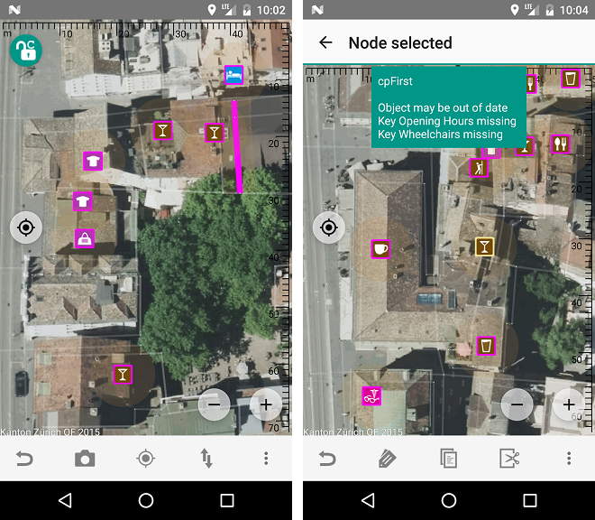
The next version of Vespucci comes with a new C-Mode to help you find objects that need your attention in an ever more densely mapped world. The warnings are based on the presets Vespucci shares with JOSM and are user configurable.
In Belgium a road completion project was started using MapRoulette. It proposes roads that are in the Wegenregister/GRB (Flemish reference base of geodata), but not on OSM. Some of them are private driveways though, so a (local) mapper’s discretion is definitely called for.
User wille announced in his blog that he set a new layer automatically accessible in JOSM and iD providing street names for Salvador da Bahia in Brazil, using the public domain data about city blocks segments provided by IBGE (the Brazilian Institute for Geography and Statistics). He proposes to repeat it for other Brazilian cities and will publish the code for the whole process.
Community
Pascal Neis posted about the recent updates to his project HDYC: “How did you contribute to OpenStreetMap?”. Users can now opt-in to make their profile public. A few more modifications on the statistics and visualisation are also part of this update.
Horea Meleg and Florin Badita were chosen as the mappers of the month in Belgium. Both work for TeleNav and mostly improve North America. In the interview they give an insight to their work.
blogs.openstreetmap.org, the website which provides a collective feed of lots of OSM related blogs, did not show new entries due to a bug on 12th and 13th November.
Zverik wrote a disheartened diary entry about his last proposal about metro mapping improvements. He shares about how a proposal can be criticised and blocked beyond its technical merits, because votes have the power to override constructive discussions.
OpenStreetMap Foundation
Martijn writes to the Talk-de mailing list, sharing the announcement of FOSSGIS eV on the application of official German representation (Local Chapter) of the OpenStreetMap. He asks the Community to share - any questions, comments or concerns they have so that they can go ahead and pursue this.
The first candidates have stood up for election for the upcoming elections to the OSMF board of directors. Links to the candidates’ manifestos can be found on the OSM wiki. Everyone can ask the candidates questions and read their responses to other users’ questions.
The 2017 Annual General Meeting of the OpenStreetMap Foundation will take place online in the IRC chat room #osmf-gm on the IRC network irc.oftc.net, on Saturday 09th December 2017 at 16:00 UTC. Further details on the Board election are available on the wiki.
As part of his candidacy for the board of the OpenStreetMap Foundation, Joost Schouppe opens up Reddit thread -
AskMeAnything in which he gets asked questions of users from all subjects.
Due to limited demand and a lack of disk space, the Operations Working Group is thinking about not offering all old planet dumps for download any more.
Events
For the fourth time there will be a Geospatial devroom at FOSDEM, and it will be happening on Sunday, 4th of February, 2018 in Brussels, Belgium! The participation is free of charge and open to all. The deadline for submitting your talk (either 10-minutes or 20-minutes long) is December 1st. All information is available in the devroom announcement.
Open Data
An article in the Frankfurter Allgemeiner makes the case that data collected on behalf of and paid for by taxpayers should be freely available - they shouldn’t have to “pay again” to see it (automatic translation).
Jakob Miksch, Martin Sudmanns and Karina Krampf won second place at the EU Datathon. They presented their webapp “LightOnEurope”, which allows to notify the public about open datasets, by drawing polygons around the area for which data is available.
Software
User nrdegroot writes in the forum about making a 3D renderer for OpenStreetMap using Mapzen and babylon.js.
Programming
Github user Halhen shows how to produce traffic density maps in Rstats using road networks from OpenStreetMap.
Mapbox Navigation SDK for iOS v0.10.0 comes with a redesigned turn banner and step table, dynamic zoom levels to show more of the road ahead, improved voice guidance, alternative routes, iPhone X support, German and Dutch localizations
Cartida, a product of Omniscale, sells individual posters and canvases based on OpenStreetMap in different colours and shapes from 29.00 €. ;-)
Maps.me is the cycling app of the week at road.cc.
Google has done a redesign to its map product Maps, which is supposed to benefit from clarity. Reddit users criticizes the poor implementation for color-blind people.
Businessinsider.de explainshow specific “mistakes” on Google Maps are intentional and are used to track copyright violations. The process of adding nonexistent streets or even whole settlements to the map is not new to map producers, and the extra map features are known as trap streets.


Leave a reply