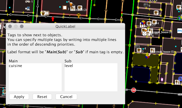
Maripo Goda published her 3rd JOSM Plugin “QuickLabel” and asks for feedback. This plugin shows any tag values next to objects. You can visualize the mapping progress of sub tags like cuisine or surface.
Mapillary introduces Mapillary Tasker, this tool will let you invite people to help complete capture, map editing, or data verification tasks in your area.
Daniel Koć asks for the tagging of leisure=common and leisure=village_green, which have their origin in British law. As they are often misused he triggers a discusion how to use the tags.
Community
Richard Fairhurst adds a section about education and socio-economic status to the Contributor Covenant and explains the rationale behind his text with reference to OSM.
Roland Olbricht queries the basis on which the proposal process on the wiki works. His concerns were heightened by the reaction to Ilya Zverev’s metro railway proposal.
Nicolas Chavent writes to the OSMF-talk mailing list about his perspective on why it’s important to balance the representation of the Humanitarian OpenStreetMap Team US Inc. at the OpenStreetMap Foundation Board (OSMF) Board to favour the
diversity of OpenStreetMap perspectives in this institutional body and also writes about HOT’s Code of Conduct. Read more about the related conversations in this email thread.
The Advisory Board of OSM UK are dissatisfied with the Directed Editing Policy and will therefore submit their own new proposal.
OpenStreetMap Foundation
Contributor Glassman writes about a proposal to OSMF adopting a Code of Conduct.
Imagico.de writes about the importance of the OSMF elections, understanding the best candidates to vote and its impact on the OpenStreetMap project as a whole.
Events
Last weekend the SotM Latam took place in Lima Peru. Some more impressions can be found on twitter as well.
Humanitarian OSM
Alessandro Venerandi works on poverty assessment using centrality criteria in OpenStreetMap data.
Severin (aka sev_osm) writes a diary post where he shares his frustrations and reasons behind his resigning from HOT US Corporation.
Rachel VanNice thanks the HOT News to the community for the valuable work and help this year. The many natural catastrophes presented a special challenge and a video supports this Thanksgiving. At the same time, she is calling for continued and even more forceful action in the future.
Maps
The OpenTopoMap now arranges summits according to their dominance. For example, at zoom level 8, mountains with a dominance greater than 100 km are displayed. See this forum post for more information.
switch2OSM
Pokemon GO has switched to OSM data in most countries. For some players this means better map data, for others there is less detail now.
Garmins uses OpenStreetMap data from now on for its Pilot 9.1 Apple app.
Open Data
The city of Cambridge (UK) have released a week’s worth of anonymised vehicle movements captured using ANPR (automatic number plate recognition).
Software
Kevin Arutyunyan has used the new 3D viewer in QGIS 3.0 to visualise OSM data. He comments that “it makes you notice how much data is still missing” from OSM to make accurate 3D maps.
Answering a question mmd, one of the main developers of the Overpass API, explains that the upcoming version will offer a way to let you determine the length of paths in meters.
Programming
Up to now,“iD” has only been able to display satellite images in 4 brightness levels. In the upcoming version it will be possible to adjust brightness, contrast, saturation and sharpness between 0 and 200% from the base value.
Komяpa is offering a $100 bounty for a mod_tile/renderd pull request. He’s hoping to improve render queue lengths on tile.openstreetmap.org.
Thomas Skowron presents in issue 59 of his podcast “Microwave”, produced in cooperation with user U-Bahnnverleih his work on vector tiles, the project Grandine, the geodata format Spaten and the problems of the rendering toolchain (raster and vector) (from 0:58:40)
The new release for Mapbox’s Android SDK v5.2.0 and iOS SDK v3.7.0 comes with client-side static map snapshots, georeferenced image sources, smooth transitions between styles, unlimited annotation images, shape annotation selection and improved VoiceOver compatibility.
The release of MapboxDirections.swift v0.14.0 and v0.15.0 comes with toll road/motorway/ferry avoidance options, property indicating whether cars drive on the right or left and much more.
Did you know …
… the affiliate links for Amazon? If you’re buying your christmas presents at Amazon, please consider using the affiliate program to help OSM ;-)
For all who want to visit a nice locality in Schweich, here is the geoportal of Schweich, made with OpenSource, where you will find extensive information on geodata and map services of the municipality Schweich.
Other “geo” things
QGIS 3.0 is on the horizon. There are many improvements and new features, which means the documentation needs to be updated and the developers could use your help with this.
The ruthenium-106 traces(Google translation) measured in the atmosphere at the beginning of October are very likely to have come from the Mayak nuclear facility. Due to the low dose, however, there was no danger to the public.
Czech Railways (national train operator) has stopped the distribution of 2018 agendas for employees and business partners. The agenda contains a small map on the last page, showing several disputed areas, ‘Islamic state’ or Russian Crimea.
Upcoming Events
Where
What
When
Country
Denver Online High School Mitchell
PoliMappers’ Adventures: One mapping quest each day


Leave a reply