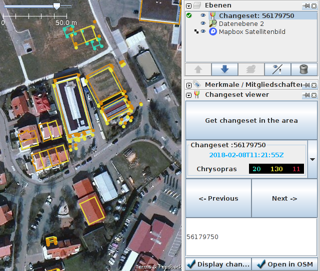
Contributor Rub21 posts about their new JOSM plugin for visualising changesets.
The OSM Argentina community discusseserrors made in Argentine territory by new mappers of a project from the National University of Asuncion (Paraguay). (automatic translation)
Christopher Beddow from Mapillary demonstrates how he used street-level imagery as a visual aid to improve OpenStreetMap after hiking in the Atlas Mountains in Morocco.
User jremillard outlines the potential benefits of applying AI technology to map from satellite imagery. Automated mapping is not going to replace human mappers in the near future, but could assist them in various ways. The comments are strongly divided between optimists and pessimists about the potential of AI-based mapping contributions.
As a follow-up to recent discussions on the use of Artificial Intelligence and Machine Learning in OSM, Christoph Hormann posts his thoughts on the way that some large companies are currently using those technologies and how things could be improved.
User Zisper asks on OSM Forum about how to map a riverbed that is walkable when dry. Intermittent rivers can already be mapped, but there is no implication that they are suitable for pedestrians. A possible solution, which raises a warning in JOSM, is to add a highway=track tag to the relevant river segment.
Community
The Open Data Institute of Cardiff asks help from the public to map street names near them using OSM as the collabaration platform, to create the first online Welsh-language map of Wales. More info can be found on ODI Cardiff website (in Welsh and English).
Christian Shadrack published in the Talk-cd mailing list, the OpenStreetMap DRC Monthly Information Report of January 2018, relating mapping parties in various neighborhoods of Kinshasa, remote mapping over flooded or cholera affected areas, a large mapathon organized at the Unikin (University of Kinshasa) and participation during a “Data collaborative” workshop.
The operators of Easylist (a collection of rules for Adblocker) are unwilling to whitelist OSM banners on the main website. These banners appeal for donations or promote community conferences organised by OSMF and its local chapters. Eastlist believe such an action would set an awkward precedent.
The GIScience group at the University of Heidelberg announced new data for wheelchair routing in the city of Heidelberg. The data were collected in collaboration with the city authorities.
Wille Marcel writes a diary highlighting the new release of OSMCha - OpenStreetMap Changeset analyser which comes with many new features such as more flexibility in posting changeset comments and a new location filter.
HOT has launched its 2018 Microgrants Programme. It will accept up to ten projects between $2,000 - $5,000 USD. Applications must be received by midnight on the 28th February 2018.
Maps
OpenMapTiles project now automatically detects visitors language and serves them labels in their mother tongue (more than 50 languages are supported). The labels are now unified by using Noto Sans font, which can display characters in almost every language.
Licences
Jason Remillard posts on Talk-US mailing list about the final steps of his import of US Northeast sports fields. He trained a neural network using Bing imagery to produce spots that he manually checked for such fields. Recently, he got the approval from Microsoft for that data to be put in OSM.
Software
Jakob Miksch describes on his blog how route planning with OSM works and which programs can be used for it.
… the OpenStreetCam support of the iD-Editor, which has been around for a few months now?
… Ilya Zverev made a map with all the global imagery layers available for tracing into OpenStreetMap? Use it to compare the dates, or to check for coverage before editing a remote region.
Other “geo” things
Datawrapper now provides a simulation tool that checks the colours of a plot or a map, so that they are colorblind-friendly. The blog article also provides tips on how to choose colour palettes and gradients.
The Spanish newspaper El País writes about an almost forgotten grove of 500 Californian Redwoods planted in Galicia in memory Christopher Columbus. Of course it is mapped on OSM.
… Lumion 8? It allows you to render architectural (automatic translation) designs with an OpenStreetMap feature where you place the design in a real-life setting.
“Burned Places” is a map of sites of Nazi bookburnings in 1933. The reference to OSM and the copyright can be found in the imprint.
The flight simulator X-Plane 11 can now use a scenery that is based on OSM data. The AddOn is free of charge and covers all of Europe.
Upcoming Events
Where
What
When
Country
Karlsruhe
Karlsruhe Hack Weekend February 2018
2018-02-17-2018-02-18
La Riche
Ubuntu Party #3
2018-02-17
Otaru
小樽マッピングパーティー
2018-02-17
Takatsuki
OpenStreetMap Frontier #01
2018-02-17
Rome
FOSS4G-IT 2018
2018-02-19-2018-02-22
Cologne Bonn Airport
Bonner Stammtisch
2018-02-20
Derby
Pub Meetup
2018-02-20
Lüneburg
Lüneburger Mappertreffen
2018-02-20
Bochum
Mappertreffen
2018-02-21
Karlsruhe
Stammtisch
2018-02-21
Lübeck
Lübecker Mappertreffen
2018-02-22
Hasselt
OSMBE Meetup
2018-02-22
Moscow
Schemotechnika 14
2018-02-22
Urspring
Stammtisch Ulmer Alb
2018-02-22
Bremen
Bremer Mappertreffen
2018-02-26
Essen
Mappertreffen
2018-02-26
Graz
Stammtisch Graz
2018-02-26
Brussels
Road Completion Workshop
2018-02-27
Viersen
OSM Stammtisch Viersen
2018-02-27
Dusseldorf
Stammtisch
2018-02-28
Osaka
もくもくマッピング! #14
2018-02-28
Minsk
byGIS #6
2018-02-28
Dresden
Stammtisch Dresden
2018-03-01
San Juan
Open (geo)Data Day 2018
2018-03-03
Hachiohji
高尾山薬王院マッピングパーティ IODD2018 Code for Hachioji
2018-03-03
Biella
Incontro mensile mapper di Biellese
2018-03-03
Cologne Bonn Airport
FOSSGIS 2018
2018-03-21-2018-03-24
Turin
MERGE-it 2018
2018-03-23-2018-03-24
Poznań
State of the Map Poland 2018
2018-04-13-2018-04-14
Disneyland Paris Marne/Chessy Railway Station
FOSS4G-fr 2018
2018-05-15-2018-05-17
Bordeaux
State of the Map France 2018
2018-06-01-2018-06-03
Milan
State of the Map 2018 (international conference)
2018-07-28-2018-07-30
Dar es Salaam
FOSS4G 2018
2018-08-29-2018-08-31
Bengaluru
State of the Map Asia 2018 (effective date to confirm)


Leave a reply