Rory McCann asks on the talk mailing list how to connect rivers that flow through lakes, thus forming a network suitable for routing calculations. Extending the riverways into the lake works fine, but the extra segment in the lake should be excluded for determining the length of the actual river.
Two tags are in use for passenger information in railway stations. The tagging mailing list discussed the pros and cons of standardising on the more widely used tag passenger_information_display=yes.
Robert Whittaker announced a tool for comparing OSM Post Office data with that recently released by the company now running post offices in the UK. The newly-released data has also been republished here by Owen Boswarva.
Community
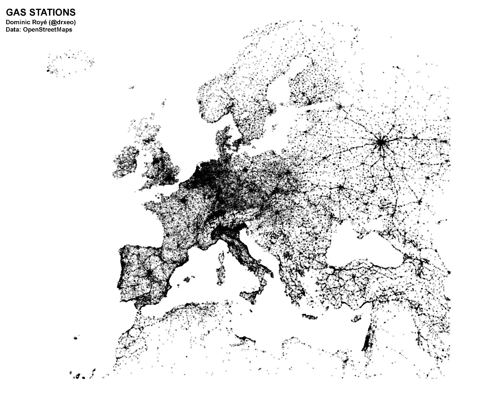
Dominic Royé tweeted a map that displays population density through the number of gas stations in Europe. A further tweet shows the same data for the whole world. The original joke, for those unfamiliar, is here.
Several users on the Talk-IT mailing list discuss (automatic translation) the use of information from Google StreetView for OSM mapping. It’s clear to everyone that plain copying is not allowed by the terms of service, and that explicitly listing StreetView among the sources for an edit is a call for legal trouble.
Alleged problems in OSM are discussed(translation) again on the German forum. The use of the OSM-Carto style as the standard map is increasingly under attack for a number of perceived weaknesses.. The thread was prompted by Serge Wroclawski’s blog entry reported here earlier).
The University of Malta and the University of New York have published a paper dedicated to the automatic creation of game puzzles using Wikipedia articles, OpenStreetMap data and Wikimedia commons.
User SeleneYang published a diary entry (translation) about the International Gender Representation Survey led by Geochicas, an OSM women’s mapping group.
The OSM-US Board has completed this year’s election process. For the first time, the board used Single Transferable Vote procedure.
Events
A “call for logo” has been announced for the State of the Map LatAm 2018, that will be held in Buenos Aires, Argentina. Deadline for submissions will be March 15th.
OSM Burundi organized its State of the Map on February 23 and announced a partnership with SmartBurundi providing free 3G SIM cards for OSM contribution.
Tickets for State of the Map 2018 are now on sale, at the Early Bird discount rate. It’s time to start planning the trip to Milan for the end of July!
Humanitarian OSM
Fanga e. V., aims to enable the youth in Burkina Faso (West Africa) to receive training and to take care of their medical care. A HOT tasking manager project has been set up to help update the map there.
A recent HOT project succeeded in mapping Dar es Salaam’s smallest decision making structures, the “shina”. These administrative units, unmapped until November 2017, are now available on an official map and will help improve public health services, emergency response and decision making for local authorities and community members. They’re not yet in OSM though - the highest level boundary currently there is at the “subward” level such as Makangarawe here.
In the International Journal of Geo-Information published (PDF) a scientific paper by Wei Liu et al. on mapping flood-prone regions in Nepal with the help of OSM.
switch2OSM
Omniscale (a map hosting company using OSM data) has released a new outdoor map style. The map is available as WMTS and WMS and is updated live. (via Twitter)
Rescue services in Luxembourg use (amongst others services) OpenStreetMap. It is the most up-to-date map in the area shown here. (via Twitter)
Open Data
Sidorela Uku reports about the first successes of the Albanian OSM community, which received geodata from the city of Tirana under an OSM-compatible license, and hopes that further cities will follow this model.
The English Environment Agency announced which areas are targeted for new Lidar imagery this winter. This is part of the programme to achieve complete coverage of England by 2020.
This year’s global Open Data Day will take place on Saturday, March 3. OSM is also represented, e. g. in Düsseldorf.
Software
The web application “is OSM up-to-date?” by Francesco Frassinelli checks for the last edit of nodes and ways, based on the assumption that older data could more likely be outdated. The application produces a colour overlay that makes these old data easy to spot.
During the most recent Karlsruhe hack weekend Hartmut added support for uploading Umap export files into his MapOSMatic instance. This now allows for easy printing of custom maps created with Umap.
Programming
Frederik Ramm has added an option to “planet-dump-ng” (which generates the the planet dumps from OSM that all other data extracts rely on). The new functionality is to optionally allow the removal of user metadata. This may be necessary because of GDPR, and also will also reduce the size of planet dumps.
Version 3.6.2 of Mapnik’s NodeJS bindings is the last one supporting Windows, unless a new maintainer can be found.
The geodata analysis team of HeiGITis currently developing a historical OpenStreetMap analysis platform. The goal is to make OSM data from the past more readily available for various types of data analysis tasks at the global level.
Mapbox Navigation SDK for iOS v0.14.0 uses Amazon Polly–powered spoken instructions by default for most languages, cleans up notifications, and displays map labels in the local language by default.
Mapbox has published revamped developer documentation about its Maps SDK for Unity.
Releases
The latest version of “OpenStreetMap Carto” (the default style on the OpenStreetMap.org website) has been released. 4.8.0 now also shows some historical tags like Wayside shrines and Forts (and discussion continues about other historical things such as castles).
QGIS 3.0 ‘Girona’ has been released for Windows, MacOS X, Linux and Android.
For most OSM applications you will find the current release, as always updated by Wambacher, on the OSM Software Watchlist.
OSM in the media
Several German news websites published a brief article on OpenRailwayMap.
Other “geo” things
A pilot project from DataSeed has succeeded in mapping high-voltage towers in Pakistan, using machine learning to speed up manual mapping. This strategy, called Intelligence Augmentation, allowed speed-ups of 16x and 19x while maintaining the quality level of manual mapping. An example of a mapped power line is here.
Google Maps rolls out the open source and royalty-free “Plus Codes” (formerly Open Location Code). There’s speculation on the effect on proprietary suppliers in that area.
Spiegel online praises (translation) the map system of Here (BMW, Daimler and Audi) in an article and compares it with its major competitors.
Bloomberg writes about the companies competing to supply highly detailed maps for autonomous driving, including Google. This is heavily discussed on Hacker News.
The magazine “Binnenschifffahrt” in German presents the digital shipping assistant (translation), an app using OSM maps for inland waterway logistics will be tested from autumn this year.
Upcoming Events
Where
What
When
Country
Lannion
3e concours de contributions OpenStreetMap
2018-03-01-2018-03-23
Montreal
Les Mercredis cartographie
2018-03-07
Stuttgart
Stuttgarter Stammtisch
2018-03-07
Praha/Brno/Ostrava
Kvartální pivo
2018-03-07
London
OpenStreetMap Q&A London
2018-03-07
Berlin
117. Berlin-Brandenburg Stammtisch
2018-03-08
Munich
Münchner Stammtisch
2018-03-08
Brussels
OSMBE Official Meeting & Meetup
2018-03-09
Buenos Aires
Geobirras
2018-03-09
Kyoto
幕末京都マッピングパーティ#02:月の明かりと大獄と
2018-03-10
Tokyo
東京!街歩き!マッピングパーティ:第17回特別編 旧東海道品川宿
2018-03-11
Rennes
12 Mar.2018-03-12–2018-03-13
Réunion mensuelle
2018-03-12
Lyon
Rencontre libre mensuelle
2018-03-13
Nantes
Réunion mensuelle
2018-03-13
Bochum
Mappertreffen
2018-03-15
Mumble Creek
OpenStreetMap Foundation public board meeting
2018-03-15
Rapperswil
9. Micro Mapping Party Rapperswil
2018-03-16
Yokkaichi
第1回 富洲原マッピングパーティ
2018-03-17
Rennes
19 Mar.2018-03-19–2018-03-20
Cartopartie bâtiments en 3D
2018-03-19
Cologne Bonn Airport
FOSSGIS 2018
2018-03-21-2018-03-24
Turin
MERGE-it 2018
2018-03-23-2018-03-24
Poznań
State of the Map Poland 2018
2018-04-13-2018-04-14
Disneyland Paris Marne/Chessy Railway Station
FOSS4G-fr 2018
2018-05-15-2018-05-17
Bordeaux
State of the Map France 2018
2018-06-01-2018-06-03
Milan
State of the Map 2018 (international conference)
2018-07-28-2018-07-30
Dar es Salaam
FOSS4G 2018
2018-08-29-2018-08-31
Bengaluru
State of the Map Asia 2018 (effective date to confirm)


Leave a reply