Stéphane Péneau wishesto crowdfund the conception and production of a GNSS receiver that would be particularly suited for OSM contributions. The ongoing discussion should help to refine the specifications.
Ilya Zverev (Zverik) posts his analysis of the impact of the new iD release: OSM-based routing engines need to correctly process the increasing number of intersections with “via” nodes and no-U-turn restrictions.
Community
Mappers from OSM Benin community, in partnership with the French Research Institute for Development and Blolab, drove during the last two weeks the MapAndJerry mapping phase, alternating training and field collection. RFI made a video reportof the event.
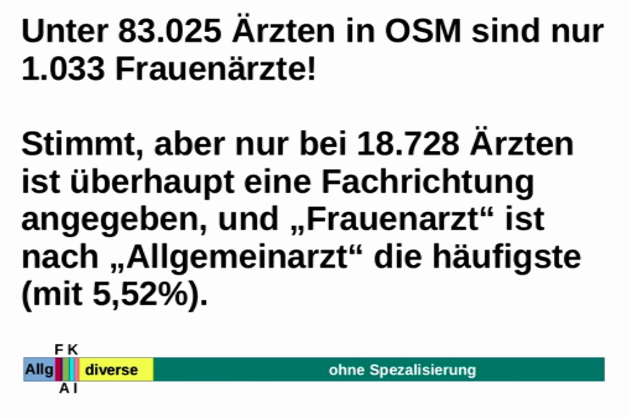
In #400 we reported about “Who Maps the World?”, published on CityLab. In his presentation at FOSSGIS 2018, Frederik Ramm tries to analysethe gender-relevant facts neutrally and with the knowledge how OSM works and comes to surprising results.
A thread on the Austrian subforum deals with the possible need of a moderator. In the end, emga and Nakaner were appointed as new moderators.
User ImreSamu has created test instances of Taginfo and made them available online for testing and feedback.
To improve the rendering of 3D models in OSM, user n42k created a repository in the last Google Summer of Code (https://3dmr.eu/) where the models are stored. He also wrote a diary entry.
OpenStreetMap Foundation
The minutes of the Membership Working Group meeting of March 20th is online. The main point on the agenda was the setup of an OSMF-owned survey engine.
The HDX (PDF) Dakar Lab reports about last year’s successes. The open platform is responsible for the collection and dissemination of humanitarian data in West Africa. One of the biggest achievements was the automatic integration with the HOT data pool.
Amelia Hunt reports on the HOT blog about improving access to health facilities in Dar es Salaam. Surveys were conducted among the population. A visualization shows problems and possible solutions. Especially in the field of obstetrics, mobile clinics could make life much easier for the female population in Tanzania.
kocio-pl prepared a pull request that makes OSM Carto display the name of large bays. The pull request got merged already.
OpenStreetBrowser has a new view that displays gastronomy POIs, with a different marker according to their smoking policy.
switch2OSM
The German national news service Tagesschau has created a news atlas on OpenStreetMap basis, which shows 24-hour news.
Releases
The osm-carto team has published a new monthly release of this style (v4.9.0), with 2 times more changes than usual. Some of them are pretty important, like long-awaited towers and masts redesign, new rendering for gardens or rendering place=square labels.
Did you know …
… the Cycling Infrastructure Prioritisation Toolkit, in short CyIPT? It’s a toolkit that identifies the best places to put new cycle infrastructure.
OSM in the media
The OpenStreetMap community in Chile has tweeted that OSM data can now be seen daily in the official news and on their Facebook page.
A magazine of the Italian public broadcaster (RAI) featured a segment on the open data world, featuring OpenStreetMap and an interview with Maurizio ‘napo’ Napolitano.
Other “geo” things
After ‘fake news’ now fake destinations on road signs.
The tree management software ImmoSpector tree listsOpenStreetMap among the possible map background layers. This software aims at monitoring tree cadasters with online tools.
Geolounge published a review of Walter Goffart’s “Historical Atlases: The First Three Hundred Years, 1570-1870”, praising its high accuracy and readability.
The launch of a SpaceX Falcon 9 rocket produced circular shock waves in the ionosphere that could lead to GPS errors of about 1 metre.
Upcoming Events
Where
What
When
Country
Montreal
Les Mercredis cartographie
2018-04-04
Stuttgart
Stuttgarter Stammtisch
2018-04-04
Bochum
Mappertreffen
2018-04-05
Dresden
Stammtisch Dresden
2018-04-05
Solothurn
2018 SOSM AGM and mapping party
2018-04-07
Rennes
Cartographie des rivières
2018-04-08
Rennes
Réunion mensuelle
2018-04-09
Toronto
Mappy Hour
2018-04-09
Lyon
Rencontre mensuelle pour tous
2018-04-10
Munich
Münchner Stammtisch
2018-04-10
Nantes
Réunion mensuelle
2018-04-10
Viersen
OSM Stammtisch Viersen
2018-04-10
Cologne
Köln Stammtisch
2018-04-11
Berlin
118. Berlin-Brandenburg Stammtisch
2018-04-13
Poznań
State of the Map Poland 2018
2018-04-13-2018-04-14
Tokyo
東京!街歩き!マッピングパーティ:第18回 本郷大横丁通り商店街
2018-04-14
Berlin
Berlin Hack Weekend April 2018
2018-04-14-2018-04-15
Disneyland Paris Marne/Chessy Railway Station
FOSS4G-fr 2018
2018-05-15-2018-05-17
Bordeaux
State of the Map France 2018
2018-06-01-2018-06-03
Milan
State of the Map 2018 (international conference)
2018-07-28-2018-07-30
Dar es Salaam
FOSS4G 2018
2018-08-29-2018-08-31
Bengaluru
State of the Map Asia 2018 (effective date to confirm)


Leave a reply