User warin asks for clarification about the water body tags seasonal, ephemeral and intermittent. The answers show how difficult it is to map irregular water flows in various climates, and to agree on unambiguous tags worldwide.
User DeBigC shares his experiences with Mapillary in Ireland, where he has, to date, collected the most photos among all contributors.
Christoph Hormann (imagico) shares his views about the various ways OSM tags can be used, or, more realistically, abused, to cause labels of various degrees of prominence to be rendered on the Carto-CSS map layer.
Currently there is a vote for taggingamenity=lounger, for non-moving sunbeds.
Community
Tim Frey, one of the creators of the STAPPZ app, asks for feedback on their open sourcing plan of the app’s content.
OpenStreetMap US now has a dashcam for loan. The camera is the Waylens Horizon which will be used to take street level photos for OpenStreetCam. After a certain threshold one could keep the camera.
Kathmandu Living Labs opened a job vacancy for OpenStreetMap Coordinator.
Nikolai Janakiev wrote an extensive article on predicting Economic Indicators with OpenStreetMap. Python source code is included.
OpenStreetMap Foundation
The OSMF board and OSM working groups are preparing for the General Data Protection Regulation (GDPR), which is in effect in Europe since May 25th, 2018.
Events
The official dates for the State of the Map Latam are out! The event will be held in Buenos Aires, Argentina, from September 24th to the 25th, during the Open Data Week.
Humanitarian OSM
On April 16-18, HOT Indonesia hosted a mapathon in collaboration with the State University of Semarang (UNNES). 25 students mapped over 47000 buildings and 290 roads, they learned to use validation and the buildings_tools plugin, as well as possible ways for exporting the data and use it for their research.
Julie Zeglen from Generocity highlighted Annaka Scheeres’ work and how it might have helped save lives with her data storytelling.
While the Ebola outbreak has spread from the countryside into the city of Mbandaka, 600 km north of Kinshasa, urgent mapping tasks await remote OSM contributors. More than 350 remote OSM contributors have collaborated to date to support epidemiologists,
Claire Halleux of Kinshasa and the OSM-RDC community coordinate this OSM response and intensify actions in support of the DRC Health Ministry, MSF, the various humanitarian NGOs and various UN agencies with remote mapping and support to the collection of essential field data and addition in OSM.
Maps
Stefan Grotz has presented his farm shop map www.farmshops.eu on the mailing list talk-de and Reddit and received plenty of feedback.
Christoph Hormann has written a blog post about how forest areas are displayed in the OSM-Carto style.
Open Data
The JungleBus team published a study comparing OSM data and Open Data GTFS Public Transport feeds for Paris and its surrounding region.
The public transport associations of Stuttgart, Munich, Hamburg, Rhine-Main and Rhine-Ruhr in Germany inaugurated their Open Data Portal.
Licences
The European Commission announces a review of the Database Directive. OSM data is currently protected under this legislation.
Software
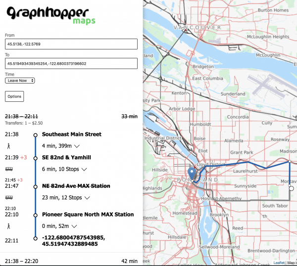
Michael from Graphhopper presents a demo of their new real-time public transit routing feature. His blog post unveils a few technical details behind the scenes.
The Overpass API has some exciting new features. Roland started a blog series to explain the new additions. One of the new features is the nwr directive, which simplifies queries to fetch all nodes, ways and relations for the set of conditions specified and avoids having to repeat them.
User demonshreddder explains how to adapt and render the OSM Carto style to your own native language.
In his OSM diary, Martijn van Exel announces that Telenav released the source code and training data sets of OpenStreetCam’s traffic sign detection. They also sponsor a competition for the improvement of automatic detection of map features from over 45,000 images.
Did you know …
… the Pic4Review tool to make mapping fun? The beta version comes with map editing missions, points and much more.
OSM in the media
The Atlantic has interviewed various actors from Kinshasa in the Democratic Republic of Congo, including Claire Halleux from OSM-DRC. They work closely with the Ministry of Health to respond to the Ebola crisis, 600 km north. Various OSM products such as printed, offline and navigation maps are already available, continuously updated by the OSM community.
Other “geo” things
Steve Bennett created a tool that can help you find the right geocoder for your project.
Upcoming Events
Where
What
When
Country
Bremen
Bremer Mappertreffen
2018-05-28
Graz
Stammtisch Graz
2018-05-28
Rome
Incontro mensile
2018-05-28
Derby
Pub Meetup
2018-05-29
Dusseldorf
Stammtisch
2018-05-30
Bordeaux
State of the Map France 2018
2018-06-01-2018-06-03
San Romano in Garfagnana
Mapathon e Editathon alla Fortezza delle Verrucole
2018-06-01-2018-06-03
Montreal
Les Mercredis cartographie
2018-06-06
Praha - Brno - Ostrava
Kvartální pivo
2018-06-06
Stuttgart
Stuttgarter Stammtisch
2018-06-06
Moscow
Schemotechnika 16
2018-06-06
Bochum
Mappertreffen
2018-06-07
Potsdam
120. Brandenburg-Berlin Stammtisch
2018-06-08
Tokyo
東京!街歩き!マッピングパーティ:第20回 江戸開城の地 芝
2018-06-09
Rennes
Cartographie des bâtiments en 3D
2018-06-10
Rennes
Réunion mensuelle
2018-06-11
Lyon
12 Jun.2018-06-12–2018-06-13
Rencontre mensuelle pour tous
2018-06-12
Nantes
Réunion mensuelle
2018-06-12
Munich
Münchner Stammtisch
2018-06-14
Milan
State of the Map 2018 (international conference)
2018-07-28-2018-07-30
Dar es Salaam
FOSS4G & HOT Summit 2018
2018-08-29-2018-08-31
Detroit
State of the Map US 2018
2018-10-05-2018-10-07
Bengaluru
State of the Map Asia 2018 (effective date to confirm)


Leave a reply