weeklyOSM 445
22/01/2019-28/01/2019
Mapping
The proposal for
crossing:island=*, which is intended to indicate the existence of a pedestrian island at a road crossing, has been approved.The new attribute
embedded_rails=*, which can be used if there is a railway on a highway and this space is shared with vehicles, has also been approved.The proposal about the mapping of disputed boundaries in OSM can now be voted on. John Paris’ proposal has reached version 1.6 and incorporates a lot of feedback based on previous versions.
Stefano Maffulli suggests formalising the key
building:soft_storey=so that it can be used if a building has at least one building level that is significantly more flexible or weak in lateral load resistance than the levels above and below. According to his proposal, the tag has already been used 13,000 times, mainly during efforts to map buildings for the Open Cities Kathmandu project.The question as to whether the tag
landuse=should be used based solely on landuse or (as it is now as a mixture of that and landcover) can lead to emotional discussions. This time the question “How should areas, which are considered as forest by authorities but look more like scrub or scree, be tagged?”, led to a discussion with around 100 responses on the tagging mailing list.An email on the Talk-Asia mailing list summarises individual assessments made by volunteer mappers about Grab’s GlobalLogic OSM team’s edits in Thailand.
Andrzej thinks that the current addressing schema does not cover all, even basic scenarios. In his mail he points to several UK-related issues and to a summary page in the wiki. This started a longer discussion on talk-GB.
In his OSM diary will_p shares his thoughts about the usage of addr:place in the UK and lists some examples which don’t meet the wiki definition by varying degrees.
Community
OSM announced the 5,000,000,000th node on Twitter. The node was added by Kazykan and belongs to a building in Russia.
Geochicas tweeted an infographic summarising their activities, projects, alliances and community growth during 2018.
Faith Taylor from the University of Portsmouth is looking for volunteer community members in Austria who can help with a mapathon during the European Geosciences Union General Assembly in Vienna the week of the 8th to the 12th of April.
The “Thanks” extension has been installed on the OSM wiki, making it easy to thank other wiki contributors for their improvements.
Mateusz Konieczny attempted to list the different roles of contributors in the OSM ecosystem.
Imports
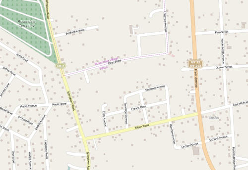
- Frederik Ramm suggested reverting a four-year-old building import in Ulster County, New York State, because only simple squares had been imported instead of the correct building outlines. Two years ago the import was featured by Worst of OSM.
OpenStreetMap Foundation
The Membership Working Group’s report on the unusual signups before the OSMF election and the board’s reaction to it sparked off numerous discussions. There have been multiple questions (some of which have so far gone unanswered) and requests for GlobalLogic employees to be excluded from the foundation.
Since the beginning of the year, the OSMF has received applications for new Local Chapters from Ireland and Uganda. All current applications can be found on the overview page.
In a blog post titled Entryism in Open Communities, Steven Feldman wonders whether he was wrong to consider concerns about corporate takeovers. He concludes that OSM and OSGeo have become mainstream; will be of interest to commercial entities; and the potential for conflicts of interest is likely to grow. He suggests revisiting the articles of association to ensure adequate protection.
Events
- OSGeo’s flagship event, the Free and Open Source Software for Geospatial (FOSS4G), which will take place from the 26th to 30th of August 2019 in Bucharest, Romania, is open for registration.
Also note that FOSS4G Italy will take place from the 20th to 24th of February in Padova.
- The State of the Map Africa, which will take place this year in Grand Bassam, Ivory Coast from the 22nd to the 24th of November 2019, is still looking (Google docs) for speakers. Proposals and nominations of suitable speakers are invited.
Humanitarian OSM
- HOT expects that the Microgrants program that was established in 2017 will provide grants to 8 to 10 communities to improve their ability “to address the barriers they face to scaling their work”. The program will focus on diversity and representation, innovation, sustainability and continuity.
Software
- Sascha Fendrich reports that the openrouteservice (ORS) team at HeiGIT, in collaboration with the VROOM project, has contributed an ORS routing backend to the VROOM software. Now, VROOM is able to solve travelling salesman and other vehicle routing problems using OpenStreetMap data. A dedicated VROOM API will soon be available via openrouteservice.
Programming
The Linux Foundation announced that the application base created by Mapzen is being merged into The Linux Foundation. Mapzen discontinued its services at the end of January 2018, due to the lack of a sustainable business model.
Will the iD editor start beeping soon? ;-) (via GitHub)
Releases
- A new version of iD has been released. The highlights of version 2.13.0 are the inclusion of quality issues from KeepRight, support for MapRules, a service to use presets from third party websites such as Radiant, and the possibility to quickly centre and zoom on a feature, note, or data issue.
Did you know …
… the JOSM Trick to switch between Dual Images (lower / higher zoom levels), you simply define a second Image Layer with a lower zoom max (i.e. z18) to avoid switching to the high zoom image when you want to interpret information from the lower image first.
… the website mapschool provides an introduction to digital cartography in English, Italiano, Español, Svenska, Français, 日本語, Português, Deutsch, Nederlands, Український and 한국어.
… PyQGIS 101 is a QGIS Python Tutorial designed for non-programmers.
OSM in the media
- English and German (automatic translation) media have also covered the signup of 100 GlobalLogic employees, which caused the investigation by the OSM Membership Working Group discussed above.
Other “geo” things
The website MIT Technology Review features an article on how crowdsourced maps can help driverless cars by solving major current issues such as the slow update cycle of road data and the sparse mapping of roadside infrastructure. According to the article, Mapillary, which creates maps and catalogues roadside objects based on uploaded streetside images, is assumed to have potential to fill the gap of missing data for autonomous driving. Mapillary, which is free for non-commercial and personal use, charges licence fees from its commercial customers.
Rose Wanjiru reflects on Kenya’s Capital FM about the importance of GIS for settlement development in Kenya and how OSM can contribute to it.
A post from a Pokémon Go player on Reddit asks how often Niantic applies updates from OpenStreetMap. Suggested dates of last update include mid 2016 and early 2017.
Switzerland’s wonderful history of detailed mapping means you can see how the country’s glaciers have shrunk over time.
In Germany, “DasDing” reports (automatic translation) that Google Maps (the smartphone application) now has warnings about speed cameras. However, this would forbid (automatic translation) the use of the app by people driving in Germany (and any other places with similar legislation).
TomTom has sold its telematics unit for $1 billion in order to better compete with Google in maps and navigation.
Finally two fascinating movies. Ten months ago photographer Páraic McGloughlin was able to compile a great animation “Arena” using images collected over months from Google Earth. His twin brother, Kevin, surpassed this with his stop-motion-style animation “Epoch”.
Upcoming Events
| Where | What | When | Country |
|---|---|---|---|
| Arlon | Réunion au Pays d’Arlon | 2019-02-04 |  |
| Toronto | Mappy Hour | 2019-02-04 |  |
| London | Missing Maps Monthly Mapathon London | 2019-02-05 |  |
| Toulouse | Rencontre mensuelle | 2019-02-06 |  |
| Stuttgart | Stuttgarter Stammtisch | 2019-02-06 |  |
| Helsinki | Missing Maps Mapathon at Finnish Red Cross HQ - Feb 2019 | 2019-02-07 |  |
| Dresden | Stammtisch Dresden | 2019-02-07 | |
| Nantes | Réunion mensuelle | 2019-02-07 | |
| Berlin | 128. Berlin-Brandenburg Stammtisch | 2019-02-08 | |
| Ulm | ÖPNV-Mapathon Ulm | 2019-02-09 | |
| Rennes | Réunion mensuelle | 2019-02-11 | |
| Bordeaux | Réunion mensuelle | 2019-02-11 | |
| Zurich | OSM Stammtisch Zurich | 2019-02-11 |  |
| Lyon | Rencontre mensuelle pour tous | 2019-02-12 | |
| Salt Lake City | SLC Mappy Hour | 2019-02-12 |  |
| Munich | Münchner Stammtisch | 2019-02-13 | |
| Barcelona | Mapes i Birres Febrer (Trobada d’usuaris d’OpenStreetMap)[1] | 2019-02-15 |  |
| Cologne Bonn Airport | Bonner Stammtisch | 2019-02-19 | |
| Derby | East Midlands Pub meetup | 2019-02-19 |  |
| Salt Lake City | SLC Map Night | 2019-02-19 | |
| Reading | Missing Maps Reading Mapathon | 2019-02-19 | |
| Lüneburg | Lüneburger Mappertreffen | 2019-02-19 | |
| Mumble Creek | OpenStreetMap Foundation public board meeting | 2019-02-20 |  |
| Karlsruhe | Stammtisch | 2019-02-20 | |
| Padua | FOSS4G-IT 2019 (OSMit2019) | 2019-02-20-2019-02-24 |  |
| Salt Lake City | SLUG meeting (with OSM presentation) | 2019-02-21 | |
| Greater Vancouver area | Metrotown mappy Hour | 2019-02-22 | |
| Biella | Incontro mensile | 2019-02-23 | |
| Manila | 【MapaTime!】 @ co.lab | 2019-02-23 |  |
| Karlsruhe | Karlsruhe Hack Weekend February 2019 | 2019-02-23-2019-02-24 | |
| Rennes | Créer ses propres cartes avec uMap | 2019-02-24 | |
| Bordeaux | Réunion mensuelle | 2019-02-11 | |
| Dresden | FOSSGIS 2019 | 2019-03-13-2019-03-16 | |
| Portmarnock | Erasmus+ EuYoutH_OSM Meeting | 2019-03-25-2019-03-29 |  |
| Montpellier | State of the Map France 2019 | 2019-06-14-2019-06-16 | |
| Angra do Heroísmo | Erasmus+ EuYoutH_OSM Meeting | 2019-06-24-2019-06-29 |  |
| Edinburgh | FOSS4GUK 2019 | 2019-09-18-2019-09-21 | |
| Heidelberg | Erasmus+ EuYoutH_OSM Meeting | 2019-09-18-2019-09-23 | |
| Heidelberg | HOT Summit 2019 | 2019-09-19-2019-09-20 | |
| Heidelberg | State of the Map 2019 (international conference) | 2019-09-21-2019-09-23 | |
| Grand-Bassam | State of the Map Africa 2019 | 2019-11-22-2019-11-24 |  |
This weeklyOSM was produced by Nakaner, PierZen, Polyglot, rogehm, SK53, SomeoneElse, Guillaume Rischard (Stereo), SunCobalt, Andrew Davidson, Tordanik, YoViajo, adrianxoc, derFred, kartonage.
We welcome link suggestions for the next issue via this form and look forward to your contributions.
Leave a reply