mapmeld made an interesting analysis of language clusters by using Unicode code points. They also detected outliers and odd forms of vandalism.
The vote on the proposal “Fashion accessory shop” has begun and runs until 8th April 2019.
The vote on “Substations functions” ended. The proposal did not achieve the necessary majority.
Community
alexkemp describes how he resolves problems encountered with OSMTracker 0.7 when pictures aren’t georeferenced. He shows how he restores the missing data.
SK53 wanted to identify areas of social housing in England. He shows in his blog how he was able to create suitable useful polygons from an open data list of individual properties with PostGIS clustering. He suggests that such approaches may have broader applicability to OSM data.
Ilya Zverev recently started working for the taxi company Juno. He describes how GPX tracks from the Juno app are being aggregated and how they can be used to keep OpenStreetMap up-to-date with very fresh data. This data is a lot easier to work with than the GPX tracks stored by OSM, which may cover multiple changes in the road network. He also presented on this subject at FOSDEM in Brussels, and his talk was recorded.
The Linuxwochen 2019 tour through Austria will be in Vienna from May 2 - 4. The article contains some links to video recordings of earlier Linux weeks.(automatic translation)
Entur and Ruter are hosting an OpenTripPlanner Summit in Oslo on 3rd April. The proceedings will be live-streamed.
Humanitarian OSM
HOT has created a new development community for the Tasking Manager with further partnerships with Microsoft and Bing Maps. Over the next few months, work will begin on the design for integrating machine-learning and improving workflow performance of the Tasking Manager. Additionally open building datasets for Uganda and Tanzania will be created.
In order to be able to help people in crisis areas quickly, NGO helpers depend on high-quality maps. For many areas, these maps must first be produced. In doing so, Doctors Without Borders is supported by modern technology and by thousands of volunteers. On Tuesday 2nd of April 2019 from 19:00 - 22:00 interested people will meet for a Missing Maps Mapathon in Berlin.
Maps
PrivateMajory tweets a 3-D effect map made using QGIS and then enhanced in Blender.
DJI appears to be using (in certain countries) OSM data in their Fly Safe GEO ZONE Map
(several examples). A tweet and emails have been sent to DJI requesting correct attribution, but sadly there was no reply from DJI.
The OpenStreetMap.be website now has a brand-new “How To” page with some tutorials and example code to demonstrate on how to use OSM and OSMBE base layer.
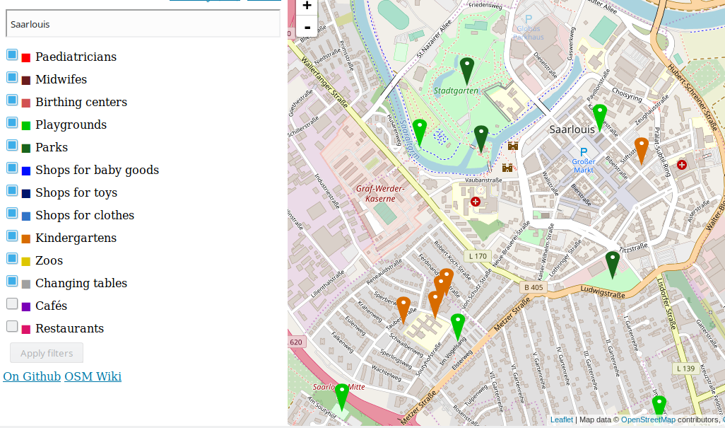
The first version of the Baby Map was published. It represents the tags that are relevant for parents of small children. However, the data in OSM is still a bit thin.
Programming
The German forum discusses (automatic translation) the categorisation of notes on osm.org. The forest of “Notes” markers is often dense and a categorisation by urgency or keywords could have a positive effect on the processing of the messages. User miche101 arranges notes on a map assigning different symbols to the markers based on keywords.
The GISience News Blog of the University of Heidelberg previews a new way to query spatial links in the OpenStreetMap history database OSHDB.
Did you know …
… the 2 Minute introduction videos to help beginners get started with OpenStreetMap and mapping for HOT-projects? Vitor George reminds us of the possibility to add subtitles to these YouTube videos.
… how to tag an area that is covered by trees, but neither tagged as landuse=forest nor natural=wood such as for example a cemetery? These can be tagged using landcover = trees along with their default landuse tags.
The Free Software Foundation (FSF) recognised OpenStreetMap with the 2018 Free Software Award for Projects of Social Benefit and Deborah Nicholson with the Award for the Advancement of Free Software. Kate Chapman received the award from Richard M. Stallman at the Massachusetts Institute of Technology (MIT) and gave a speech on behalf of OSM/OSMF community.
The Open Mapping Group at McGill University in Montreal, Canada, hosted an indoor mapping party in the face of frosty weather.
Other “geo” things
The International Telecommunication Union (ITU) published a report on reliefweb.int about the use of disruptive technologies in disaster management. The digital technologies that are supported by many volunteers around the world in the crowdsourcing projects such as OSM are highlighted in particular.
Nazi spies, untroubled by the Soviet authorities, made a complete map of Moscow during the late 1930s.
Yahoo Japan news reported that Google Maps data of Japan has deteriorated. Users assume that the data source has switched, because the copyright attribution of Zenrin has disappeared.
Grab Malaysia and The Department of Geoinformation, of the Universiti Teknologi Malaysia, organise mentoring training for mappers valled Grab Geo*Star in order increase the interest of students in the areas of mapping and OpenStreetMap.
Mapbox reports that it enhanced its living map platform with proprietary data from Zenrin, a Japanese map publisher. It is not clear as to whether enhanced was used synonymously for “replaced OSM”.
It’s not just OSM that suffers from the occasional broken polygon. Simon Poole spotted woods near Zurich which have disappeared on Here and Bing maps.
The book Time for mapping: Cartographic temporalitiesdeals with the entry of the temporal into maps in the digital age and contemporary mapping practices.
The children’s book Lindsey, the GIS Specialist introduces the basics of GIS. This is one of a small series published by the US-based surveying firm Bolton & Menk, based on the job roles of their own employees.
A Guardian quiz shows population density maps of various cities. Can you identify them? Or do you have to guess?.
Esri announces on their ArcGIS blog that the new March version (previously beta) of the OpenStreetMap Vector Basemap is now freely available in ArcGIS.
On the south coast of Norway the first underwater restaurant in Europe opened (automatic translation). Potential visitors have to wait half a year to get a reservation due to it being booked out. It is still only mapped as a construction site in OSM.
Upcoming Events
Where
What
When
Country
Sydney
Sydney OSM get together
2019-03-30
UCL Louvain-la-Neuve
National Mapathon
2019-03-30
ULIEGE Liège
National Mapathon
2019-03-30
Bochum
Mappt die Innenstadt - Mappingtag für Einsteiger*innen und Fortgeschrittene
2019-03-31
Stuttgart
Stuttgarter Stammtisch
2019-04-03
Bochum
Mappertreffen
2019-04-04
Nantes
Réunion mensuelle
2019-04-04
Dresden
Stammtisch Dresden
2019-04-04
Heidelberg
DisasterMappers Night of Geography
2019-04-05
Cayenne
Rencontre mensuelle
2019-04-05
La Riche
La Riche (37)#Ateliers d’initiation à OpenStreetMap


Leave a reply