Joseph Eisenberg drafted a proposal for golf=cartpath, which is intended for paths within golf courses that are designated for golf carts.
Leif Rasmussen incorporated feedback on his connectivity=proposal and asks for final feedback before he moves to the voting phase. The proposal aims to improve the ability to store much richer data about lanes than is currently possible with turn:lanes=.
Joseph Eisenberg proposes unifying the tags for individual pitches within a campsite and suggests deprecating camp_site=camp_pitch and camp_site=pitch and replacing these tags with tourism=camp_pitch.
Community
Tense discussions about iD and the legitimation of the iD maintainers to unilaterally decide mapping questions such as the implementation of new tags without the OSM community resurfaced following the widely, on GitHub, OSM’s tagging mailing list and the general mailing list disputed decision to implement a validation rule asking to add highway=footway to railway/public_transport=platform. The disputes followed shortly after the invention of nosquare=yes to “resolve all unsquare way issues” which was also widely challenged on GitHub and the general mailing list. During the discussion some ideas like an iD fork or potential policies for developers were raised. Unfortunately the discussions escalated and led the iD maintainer Bryan Housel to lock a ticket in GitHub which was seen as rant by others and led SomeoneElse to submit a code of conduct complaint about the used comment. The discussion spilled over to the mailing list of the OSM Foundation, where Christine Karch offered a slot at the upcoming SotM on 21–23 September 2019, an offer declined by iD’s key maintainer Bryan Housel.
Researchers from Denver & Singapore published a paper entitled Corporate Editors in the Evolving Landscape of OpenStreetMap in the ISPRS International Journal of Geo-Information (an open-access journal hosted by MDPI).
The paper describes the influence of corporate editors such as Apple, Microsoft, and Facebook on the development of OSM in the historical development of these activities. The investigation, which was carried out on the basis of 10 selected companies, found that corporate mapping focuses thematically on roads and raised questions about how OSM should deal with the growth in corporate edits.
The latest issue of the International Journal of Geographical Information Science has a number of papers about “Volunteered Geographical Information”, many based on analysing OpenStreetMap contributions. Haklay et. al. provide an overview in their editorial.
Apparently, the OSM forum is having issues with right-to-left written scripts. The failure to support scripts used in large parts of the world collides with OSM’s mission to build and support local communities. (The forum link requires OSM login to view.)
A new UN report notes growing interest in crowdsourced maps and calls OpenStreetMap “foundational to almost all risk sciences”.
Events
State of the Map France announced the provisional programme for the 2019 conference, to be held in Montpellier in the middle of June. They encourage you to register.
Ticket sales for the State of the Map conference 2019 in Heidelberg, Germany, has just started. Early Bird discounts are available for a limited albeit undisclosed time.
Humanitarian OSM
Missing Maps report on their blog a recent mission by member organisation CartONG to Burkina Faso. Prior to on-the-ground mapping, informal settlements around Ouagadougou were mapped remotely in mapathons. The team from CartONG collaborated with a local group, Yaam Solidarité, to train surveyors and collect map data.
Maps
Campaigning has started for the municipal elections in Chelyabinsk, Russia. A website showing(automatic translation) the electoral districts and their candidates is based on OSM.
Steve Coast pointed to a First You Make the Maps titled story-map that explains how cartography has made global trade possible.
Mapbox announced that it now offers traffic data that can be used in conjunction with HERE, TomTom and OSM maps. The traffic data is collected by 45,000 Android and iOS apps and the daily total is 300 million miles driven globally.
gicycle used OSM data to show that a plan to ban betting shops from within 800 m of schools in Salzburg would amount to a complete ban.
The Russian portal “Current time” published an OSM-based interactive map (automatic translation), which shows the current formal status of the Russian language in all former Soviet republics.
switch2OSM
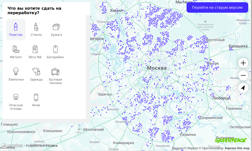
[1] Greenpeace switched its “Recycle map” in Russia from Google to OSM. Now the project is in the beta-testing phase.
Licences
Nuno Caldeira isn’t very happy with Facebook not attributing OSM and expresses this in a Tweet.
Software
Maps.Me has again started to make a weekly upload of maps for its navigator. However, the installation should be done manually.
Russian non-profit “Social technology greenhouse” created a plug-in for WordPress, which makes it possible to place an OSM map into the blog. They would be glad if anyone tested this plug-in and gave them feedback.
Programming
Pierre Béland has added preliminary versions of PostGIS Orthogonal Functions, for transforming building polygons, to the OQ_Analysis Github repo.
Releases
A new version of iD has been released. The new version v2.15.0 comes with a major improvement of iD’s validator, the ability to square unclosed lines and individual corners, straightening is now possible on sub-sections of lines and many more improvements, new features and fixes.
Did you know …
…the R242 road to Malin Head on the Inishowen Peninsula in County Donegal, Ireland was recently renamed to R2D2 in tribute to the robot from Star Wars. The area features in The Last Jedi (Star Wars Episode VIII) filmed in 2016. The road has not yet been updated on OSM as there was concern this was a hoax.
Ed Freyfogle (OpenCageData) was interviewed about geocoding on the MapScaping podcast.
update: Mapillary opened a marketplace for street-level imagery and the manual validation of geospatial data extracted from images using Mapillary’s Machine Learning technology.
Mapbox changed their pricing scheme to use a new calculation method. Details can be found on the Mapbox Blog. The old pricing can be viewed on the Internet Archive.
Upcoming Events
Where
What
When
Country
Joué-lès-Tours
Stand OSM sur la fête du vélo
2019-06-01
Taipei
OSM x Wikidata #5
2019-06-03
Toronto
Toronto Mappy Hour
2019-06-03
London
Missing Maps Mapathon
2019-06-04
Essen
Mappertreffen
2019-06-05
Toulouse
Rencontre mensuelle
2019-06-05
Stuttgart
Stuttgarter Stammtisch
2019-06-05
Bochum
Mappertreffen
2019-06-06
Mannheim
Mannheimer Mapathons
2019-06-06
Nantes
Réunion mensuelle
2019-06-06
Dresden
Stammtisch Dresden
2019-06-06
Reutti
Stammtisch Ulmer Alb
2019-06-06
Dortmund
Mappertreffen
2019-06-07
Tokyo
首都圏マッピングパーティー トキワ荘があった街
2019-06-08
Biatorbágy
Biatorbágy mapping party
2019-06-08
Biella
Incontro mensile
2019-06-08
London
Palestine Open Maps Mapathon: At the British Library
2019-06-08
Rennes
Réunion mensuelle
2019-06-10
Bordeaux
Réunion mensuelle
2019-06-10
Lyon
Rencontre mensuelle pour tous
2019-06-11
Salt Lake City
SLC Mappy Hour
2019-06-11
Zurich
OSM Stammtisch Zurich
2019-06-11
Bordeaux
Réunion mensuelle
2019-06-11
Hamburg
Hamburger Mappertreffen
2019-06-11
Leoben
Stammtisch Obersteiermark
2019-06-13
Munich
Münchner Stammtisch
2019-06-13
Berlin
132. Berlin-Brandenburg Stammtisch
2019-06-14
Montpellier
State of the Map France 2019
2019-06-14-2019-06-16
Essen
5. OSM-Sommercamp und 12. FOSSGIS-Hackingevent im Linuxhotel


Leave a reply