The latest version of “How Did You Contribute” by Pascal Neis now usesosmose to display information about the quality of the user’s edits.
Facebook’s Maps Team announced the RapiD Editor based on iD, which enables mappers to convert data they extracted using machine learning into OSM features.
WiGeoGIS, a contractor of the fuel station chain OMV, announced plans to improve and maintain fuel stations of the brands OMV, AVANTI, Petrom, FE Trading and EuroTruck in OSM. See also the discussion on the Talk mailing list (May, June).
Valor Naram put a revised version of changing_table=* tagging to a vote.
Developers of the Maps.me navigator, which uses OSM data, created a validator for underground railways (subways/metros) all over the world.
Community
Simon Poole made some suggestions on the Tagging mailing list on how to deal with the increasing number of messages and proposals there. There were lots of replies.
Recently the Kazakhstan OSM community created a Telegram chat.
OpenStreetMap Foundation
Joost Schouppe reports about the OSMF Board meeting in Brussels (including discussing the survey that was carried out beforehand) on the OSM Foundation’s blog.
Events
OpenStreetMap Argentina announces a local State of the Map to be held on Saturday 27th July in Santa Fe.
Humanitarian OSM
HOT shares on their blog about an experimental version of the Tasking Manager which incorporates machine learning assistance for various tasks.
Simon Johnson writes on Medium about how “big data” in the humanitarian community is often at odds with the idea of “minimum viable data” - the idea that less data is actually more valuable because it’s better quality and easier to verify.
In Better Bombing with Machine Learning Frederik Ramm points out that computer vision/machine learning could be used by military forces for aerial bombing, and the OSM community should consider whether we should be so jubilant regarding companies that use those technologies for improving OSM.
Maps
Richard Fairhust tweets an example of using Lua to automatically transliterate names whilst processing OSM data for rendering. Post-processing OSM data in this way often removes the need for many name:<iso-code> tags.
The map of electoral districts on the website of the Magnitogorsk City (in Russia) is based on OSM.
A map of roads that are or will be repaired has been posted on the website of the Russian federal program “Safe and high-quality roads”. It is based on OSM but first you need to choose a region.
Releases
A new stable JOSM version (15155) was released. Category icons and a field for filtering background image settings have been added. Dynamic entries in the Background Images menu are displayed in submenus as well as many more improvements.
The OsmAnd Online GPS Tracker has been updated to version 0.5. New features are contact search, proxy settings, GPS settings and active markers.
Thanks to v2.0 of Babykarte, babies will not lose their way anymore. Or rather, it will become easier for parents to find baby and toddler friendly amenities (map).
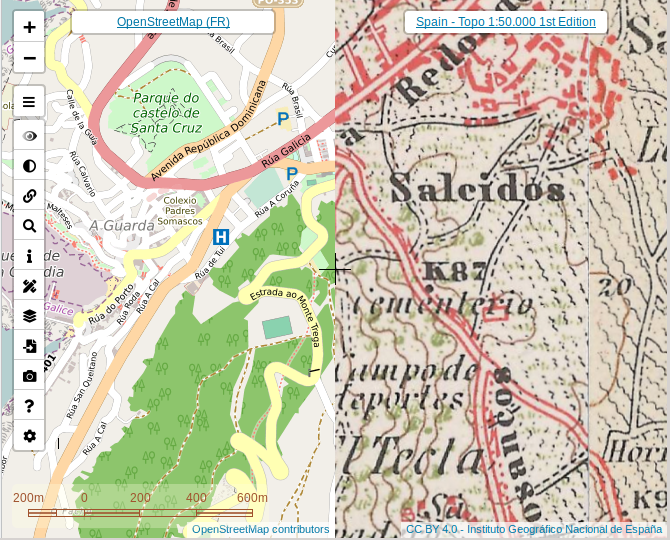
Javier Jiménez Shaw, a Spanish software engineer who lives and works in Berlin, has combined many historical, topographic, satellite and road maps (as we have mentioned here previously). He migrated the map page to Leaflet.
This short podcast from BBC Radio 4 asks the question: are there more stars in the universe than grains of beach sand on Earth? A contributor to the programme, using the OSM Planet File, computed an approximation for the amount of beach sand on the planet Earth.
An interview with Russian mapper Ilya Zverev has been postedon Habr. He spoke about what he did during his two years on the OSMF Board, why the American OSM society is the most friendly and why you need to participate in offline conferences. (automatic translation)
John Murray has been using the recent release of Rapids AI, a data science library for GPUs, to compute distances to everywhere in Great Britain from a point in a few seconds.
An extract from a forthcoming book by Barbara Tversky discusses “What makes a good map?”
An outdoor clothing company has been sneakily adding photos of its products to Wikipedia articles, in an attempt to get their brand higher up in Google image results. Just another danger of an open wiki system that we must be aware of.
Daniel J-H announced the release of a new version of RoboSat, which can detect roads and buildings in aerial imagery.
Die Welt has an article (automatic translation) about the best apps for water sports enthusiasts.
Upcoming Events
Where
What
When
Country
Rennes
Réunion mensuelle
2019-06-10
Bordeaux
Réunion mensuelle
2019-06-10
Lyon
Rencontre mensuelle pour tous
2019-06-11
Salt Lake City
SLC Mappy Hour
2019-06-11
Zurich
OSM Stammtisch Zurich
2019-06-11
Bordeaux
Réunion mensuelle
2019-06-11
Hamburg
Hamburger Mappertreffen
2019-06-11
Wuppertal
Wuppertaler Stammtisch im Hutmacher 18 Uhr
2019-06-12
Leoben
Stammtisch Obersteiermark
2019-06-13
Munich
Münchner Stammtisch
2019-06-13
Bochum
Mappertreffen
2019-06-13
Berlin
132. Berlin-Brandenburg Stammtisch
2019-06-14
Montpellier
State of the Map France 2019
2019-06-14-2019-06-16
Essen
5. OSM-Sommercamp und 12. FOSSGIS-Hackingevent im Linuxhotel
2019-06-14-2019-06-16
Kyoto
京都!街歩き!マッピングパーティ:第9回 光明寺
2019-06-15
Dublin
OSM Ireland AGM & Talks
2019-06-15
Santa Cruz
Santa Cruz Ca. Mapping Party
2019-06-15
California
Cologne Bonn Airport
Bonner Stammtisch
2019-06-18
Lüneburg
Lüneburger Mappertreffen
2019-06-18
Sheffield
Sheffield pub meetup
2019-06-18
Rostock
Rostocker Treffen
2019-06-18
Karlsruhe
Stammtisch
2019-06-19
London
#geomob London
2019-06-19
Leoberdorf
Leobersdorfer Stammtisch
2019-06-20
Rennes
Préparer ses randos pédestres ou vélos
2019-06-23
Bremen
Bremer Mappertreffen
2019-06-24
Angra do Heroísmo
Erasmus+ EuYoutH_OSM Meeting
2019-06-24-2019-06-29
Salt Lake City
SLC Map Night
2019-06-25
Montpellier
Réunion mensuelle
2019-06-26
Lübeck
Lübecker Mappertreffen
2019-06-27
Mannheim
Mannheimer Mapathons e.V.
2019-06-27
Düsseldorf
Stammtisch
2019-06-28
London
OSMUK Annual Gathering including Wikidata UK Meets OSM


Leave a reply