In the Austrian province of Tyrol, there is often an increase in traffic on long weekends during the summer holiday period. This often results in long-distance traffic, coming to or from Italy and Germany, clogging up local roads when seeking a diversion from main routes. Politicians have now tried to prevent this by ordering weekend restrictions on long-distance traffic using local roads until 14 September. The information on the closures has been transmitted to navigation equipment manufacturers via the Ministry of the Interior. Rainer Fügenstein therefore asks Talk-at how this information can be handled in OSM.
Michael Brandtner suggestsamenity=power_supply to mark places that provide free or paid access to an electrical outlet. The proposal includes subtags to describe the used socket, the fee, the operator, the capacity and some more. (Nabble)
After surveying the area and discussing with local inhabitants an Australian mapper suggests that parts of the Gwydir River mapped in OSM from “official” sources isn’t there any more and should be removed, due to changing water use. The mapper assumes that the “river on the map may be a political imperative for government.”
Richard Fairhurst describes the latest addition to the on-line editor Potlatch-2. Specific relations can now be assigned to a function key thus simplifying the process of adding ways to a route relation. In the comments he also provides some additional hints as to how function keys can also be used for adding groups of tags.
WoodWoseWulf provides a lot of information in his user diary about Niantic’s Pokémon Go from an OSM perspective. He explains the game terms, how the game mechanic is influenced by OSM data and the types of “vandals” with their motivation and the type of OSM data manipulation.
Community
The OpenStreetMap website is available in မြန်မာဘာသာ. As you probably know, it is Burmese, officially language in Myanmar with 33 Million native speakers. In the announcement tweet Andy Allan asks for help to get your language above the 25 percent threshold.
Andy Allan and Ian Dees are looking for ways how to overcome persistently unfriendly and destructive behaviour which occasionally surfaces in the OSM community, especially in some mailing lists and on GitHub, and change it to a supportive and welcoming community. Ian Dees asks for an Open Source Community Manager who can help with the harsh manners that people experience too often when using OSM’s more or less anonymous communication channels.
Candidates for this year’s OSM Awards can be nominated until 15 July.
A team of five volunteer mappers from the Ghanaian OSM and Open Source communities travelled Ghana the Open Source Way; mapping, capturing street-level images and building capacity in OpenStreetMap and FOSS.
Following the OSM community survey asking for the main topics from a contributor’s perspective that should be discussed in the recent OSMF board meeting, the OSMF board published the outcome of the survey. In a blog post Christoph Hormann criticizesquestionable ideas and tendencies and shares his thoughts on surveying the views of the community.
OpenStreetMap Foundation
We would like to join the JOSM team and many others in spreading the message of the Operations Working Group, which is looking for volunteer helpers.
Events
Christine Karch asks on Osmf-talk for ideas where the SotM 2020 could take place as there are no candidates yet.
The State of the Map 2019 conference is just around the corner. The program for this major OSM event, taking place on 21 to 23 September 2019 in Heidelberg, Germany, is available at the SotM homepage.
Humanitarian OSM
At the World Refugee Day on 20 June, medium.com published an article about the joint efforts of Oregon State University, HOT and Development Seed to find refugees and internally-displaced persons following a conflict or a disaster to allow support of these people. The article explains the scale of the issue, how the task is solved and concludes with hopes that AI will allow to help more people in the near feature.
Maptime Salzburg will hold two YouthMappers workshops at the upcoming AGIT. The first workshop provides an introduction to humanitarian mapping, whilst the second deals with the establishment of a network of YouthMappers-Chapters in European institutions in order to promote and formalise their cooperation. The YouthMappers initiative was founded by students from US universities and already includes 143 YouthMappers Chapters in 41 countries.
The nomination for the upcoming HOT board election closed on 17 June 2019. There are 8 candidates for 7 available seats. Following a decision of the board the size of the board will increase by two to seven members.
Rebecca Firth from HOT explains how street-level imagery is used to improve OSM data in undermapped regions, in particular data about waste management, road conditions and other pressing issues.
Education
The small e-learning project OpenSchoolMaps from the Swiss chapter SOSM was supplemented with special teaching material (PDF): “Mapping the environment yourself”, currently in German only. Information for instructors and a worksheet for participants explain how to organize an “outdoor mapping event” and what participants should know about it. Outdoor mapping events include mapping parties and project days for school classes. Feedback is welcome, preferably as an issue on the GIT repository.
The Portuguese version of the Historic Place website has been updated. Currently the website has a complete interface in Brazilian Portuguese.
Open Data
The Yandex Company, simply put the Russian version of Google, allowed(automatic translation) OSM to use information from Yandex.Panoramas for specifying data in OpenStreetMap. This time by e-mail.
Software
Mateusz Konieczny has received a grant from NLnet as part of NGI Zero to work on StreetComplete. He will work mostly on open issues in GitHub.
The online service Sight Safari, which can build sightseeing routes, became a mobile app for Android. It’s now in the beta-testing stage. Of course, it uses OSM as a base map.
Releases
QGIS releases both the latest version 3.8 (Zanzibar) and a long-term release (LTR) (3.4.9). LTRs remain current for at least a year.
… the mobile app “OsMo monitoring” by Konstantin Moshkov? It’s a GPS tracker which allows you to share your location with others. You can also arrange a group tracking. It uses OSM as a base map, but the naming of the data origin leaves a lot to be desired.
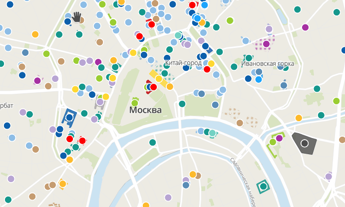
… that the Russian company NextGIS together with the international non-profit organization “Memorial” created a map “It’s right here: Moscow. Topography of terror”. The map shows places in Moscow which are connected with terror in Soviet times. They use OSM as a base map.
… the difference between amenity=post_box and amenity=letter_box? The first one is the place you put letters to be sent, the second one is the private mailbox to receive letters. These can serve as orientation points in very rural areas where mailboxes are placed along the main roads far away from buildings.
Other “geo” things
The Twitter user cartocalypse has published his souvenir of a QGIS-CH meeting.
WGS84 is the way in which OSM data is stored, but it turns out that it’s not as simple as first appears.
A report by orf.tirol shows how important geodata are for the missions of blue light organisations. It mentions the GIS tiris, which supports 358 fire brigades in the form of a web GIS.
According to the website thedailystar.net Facebook has unveiled an exclusive high definition area map generated by their AI team. The company claims that their population map is three times more detailed than any other source. Facebook will make the map available to the public, mainly for humanitarian purposes.
Michael Sumner tweets about a work that deals with the geolocalization of animals with light-detecting data loggers.
Google seems to struggle with hundreds of thousands of fake business listings that appear on Google Maps each month. According to an article at The Verge there are currently more than 11 million fake profiles in Google Maps.
A couple of Economists report on how customer ratings of food outlets in tourist areas is negatively correlated with proximity to tourist sites. Their analysis used Yelp ratings and OSM geographies.
The district Berlin Friedrichshain-Kreuzberg has published a map, and the underlying data, of drinking fountains.
Upcoming Events
Where
What
When
Country
Angra do Heroísmo
Erasmus+ EuYoutH OSM Meeting
2019-06-24-2019-06-29
Düsseldorf
Stammtisch
2019-06-28
London
OSMUK Annual Gathering
2019-06-29
London
Wikidata UK Meets OSM
2019-06-29
Kyoto
幕末京都オープンデータソン#11:京の浪士と池田屋事件
2019-06-29
Sakai
百舌鳥古墳群マッピングパーティ
2019-06-30
London
Missing Maps Mapathon
2019-07-02
Žilina
Missing Maps mapathon Zilina #5 at Faculty of Management Science and Informatics University of Zilina


Leave a reply