weeklyOSM 556
09/03/2021-15/03/2021
Mapping campaigns
- Two schools in Portugal and Romania, both members of the Humanitarian OpenStreetMap Erasmus+ project, are carrying out a three-day mapathon together with UN Mappers.
Starting on Monday 22 March ‘remaining works’ in Terceira are on the programme. On Tuesday and Wednesday, work will be carried out on a previously unpublished project of the UN Mappers. It looks like they want us to support the blue helmets of the MINUSMA-Peacekeeping mission in Mali (which includes the Romanian blue helmets).
Mapping
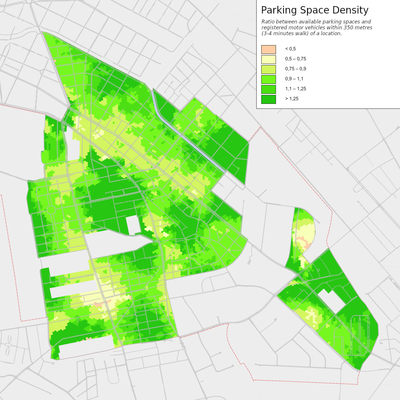
User Supaplex030 has performed a detailed analysis of parking spaces (both on- and off-street) in the Berlin suburb of Neukölln. This necessitated detailed mapping in OSM of parking, and other things which affect availability of parking places (driveways) along the street.
Simon Poole showed how minor geometry errors can creep into maps, even those from major providers.
Benjamin Herfort describes in part 4 of ‘How to monitor humanitarian mapping in the HOT Tasking Manager’ the global statistics available – such as the number of projects, participants, buildings, roads, etc. – and the various possibilities to dig into these metadata.
Paul The Archivist explained how he approaches the detailed 3D mapping of a town centre: in this case Hertford, north of London. There are useful tips on workflows and being selective about which buildings are mapped in detail.
A request has been made for comments on the following proposal:
ref:find_a_grave=*linking to the FindAGrave identifier in order to provide more information about the person while limiting the data volume occupied on OpenStreetMap.
Voting is underway for the following proposals:
place_of_worship=holy_wellfor places where Catholics, in countries like Ireland, celebrate the well’s patron saint with a mass once a year, collect ‘holy water’ and leave votive offerings (till Thursday 25 March)emergency=lifeguardto indicate where a lifeguard will be while they are on duty (till Tuesday 30 March).
The area around the village featured in changeset 100 million is now densely mapped.
Community
Bert -Araali- Van Opstal complained about the behaviour of some members in the Discord channel devoted to OSM.
Pascal Neis has previewed some proposed new #map view filters for the ‘Latest OpenStreetMap Edits per Tile’ in his resultmaps. Features like OAuth, login for saving the filters, list of friends and so on are not yet implemented. Pascal is asking for feedback.
Imports
It is proposed to import building outlines from official data in Norway. The timescale from proposal to starting the import is somewhat ambitious, being only two weeks.
Abdullah Abdulrhman reported the completion of importing governorates’ administrative boundaries in Saudi Arabia to OSM and asks the community to review this work to make sure everything is OK.
Local chapter news
OSGeo Oceania announced the opening of its Microgrants program. The program will support local activities linked to open geospatial software or data with up to $250 AUD.
OpenStreetMap Belgium’s Mapper of the Month for March is Gustavo Soares (PlayzinhoAgro).
Events
- The call for sessions (talks, workshops, and discussion panels) is now open for State of the Map 2021, which, as last year, will be held online. The deadline for proposals is Sunday 4 April.
Humanitarian OSM
HOT presented a map of COVID-19 response remote mapping activity around the world.
HOT also presented a story map of their disaster actions in 2020. The context of the actions is presented along with global contributor statistics.
Maps
- Amateur radio operators are keen to discover new technologies and this includes mapping. Many applications make use of OSM, such as the positional tracking service APRS with its APRS-Map, which displays the distribution of KiwiSDR receivers, or the popular Repeater Map, which shows the position of amateur radio repeater stations. However, amateur radio operators are not just consumers of but also contributors to OSM. You can find them everywhere, writing for weeklyOSM, just mapping, or on the OSMF board. So it is not surprising that there are amateur radio functions in OSM community projects like the optional QTH locator layer, which is a special geographic co-ordinate system, on the OpenTopoMap.
Software
Roland Olbricht was delighted to announce the first contribution by an Overpass user other than himself to the Overpass blog. Antoine Riche provided an in-depth look at how to use some of Overpass’s new features to count roundabouts in France.
Via Epona is an app aimed at helping you to discover the French terroirs (traditional farming regions) by bicycle. Its first public version is coming out on Sunday 21 March, the second day of spring.
qeef has refactored ‘Divide and map. Now.’, a tool for collaborative mapping. In his current diary entry he summarised how the clients now look.
Programming
- OpenStreetMap has once again been accepted as a mentoring organisation for Google Summer of Code. Now there is a search for projects and people to mentor them. The current list is here.
Did you know …
… paleochannels (as recently discussed on the tagging mailing list) are former courses of a river within a floodplain. Changes in some rivers, such as the Mississippi, have been intensively documented, while others are plainly visible on aerial imagery.
… there are services that let you compare maps from different sources? One of these is CompareMaps.drona.ro, which offers an easy comparison of Google Maps, OpenStreetMap, Bing Maps, and HERE Maps.
| Where can I get help, where can I find people to talk to? |
|---|
| ### |
| International - Multilingual Channels |
| * international mailing lists |
| * Forum from Android to Wiki team and from Albania to Venezuela |
| * Discord |
| * Mastodon |
| * Matrix |
| * Slack |
| * Telegram |
| * IRC channels |
Other “geo” things
The pop artist Ed Ruscha documented the buildings of Sunset Strip in the 1960s with a wealth of photographs. Now Stamen have created an immersive experience from the photo archive, which is in the Getty Collection.
The Myriahedral Projections representation shows the many ways we can cut up the globe and place it flat on a piece of paper.
Matthew Earl has succeeded in projecting the footage of the Perseverance Rover’s approach to Mars onto satellite imagery from the Mars Express Orbiter. Here he explains how he did it.
Déjà vu. Google Maps allows editing again.
Upcoming Events
| Where | What | Online | When | Country |
|---|---|---|---|---|
| Пенза | Online mapping party in Penza (Домашняя картовечеринка в Пензе)  | 2021-02-19 - 2021-03-31 |  | |
| Cathair na Gaillimhe | #MapPatrick  | 2021-03-17 - 2021-03-21 |  | |
| WikiDonne meets cOSMopolIT  | 2021-03-20 | |||
| Angra do Heroísmo | Mapathon UNmappers & euYoutH_OSM  | 2021-03-22 |  | |
| Missing Maps CartONG Mapathon  | 2021-03-22 | |||
| Bremen | Bremer Mappertreffen (Online)  | 2021-03-22 |  | |
| Râmnicu Vâlcea | Mapathon UNmappers & euYoutH_OSM  | 2021-03-23 |  | |
| Missing Maps CZ Mapathon 2021 #2  | 2021-03-23 | |||
| Geomob ft. Michael Montani (Unite Maps, UN Mappers)  | 2021-03-24 | |||
| Osborne County | ✓ | 2021-03-25 |  | |
| Osborne County | OpenStreetMap U.S. Virtual Mappy Hour  | ✓ | 2021-03-25 | |
| GISRUK Webinar: Semantic geographic knowledge on a world-scale, interlinking OpenStreetMap and knowledge graphs  | 2021-03-25 | |||
| UN Mappers weekly mapathon  | 2021-03-25 | |||
| Boston | Challenging Sexism and Misogyny in the Open Mapping Ecosystem  | 2021-03-26 | | |
| Mapio Cymru: Found in a map of Wales Workshop  | 2021-03-26 | |||
| [Online] OpenStreetMap Foundation board of Directors - public meeting  | 2021-03-26 | |||
| Webinar GEAM - GFOSS.it: OpenDroneMap, un ecosistema libero per foto aeree  | 2021-03-26 | |||
| Collaborative and Humanitarian Mapping #3: Mapping informal settlements with Mapillary and JOSM  | 2021-03-26 | |||
| Düsseldorf | Düsseldorfer OSM-Treffen (online)  | 2021-03-26 | | |
| Biella | Incontro mensile OSMers BI-VC-CVL (online)  | 2021-03-27 |  | |
| Budapest | Exhaustive mapping within certain Budapest administrative boundaries (Hungarian)  | 2021-03-29 |  | |
| Missing Maps CartONG Mapathon  | 2021-03-29 | |||
| Missing Maps DRK Online Mapathon  | 2021-03-30 | |||
| Ville de Bruxelles - Stad Brussel | Virtual OpenStreetMap Belgium meeting  | ✓ | 2021-03-30 |  |
| UN Mappers weekly mapathon  | 2021-03-31 | |||
| San Jose | Virtual Civic Hack & Map Night  | ✓ | 2021-04-02 | |
| 京都市 | 京都!街歩き!マッピングパーティ:第23回 Re:常寂光寺  | 2021-04-04 | jp | |
| Heidelberg | Mapathon  | 2021-04-06 | | |
| London | Missing Maps London Mapathon  | ✓ | 2021-04-06 | gb |
| Landau an der Isar | Virtuelles Niederbayern-Treffen  | ✓ | 2021-04-06 | |
| Stuttgart | Stuttgarter Stammtisch (Online)  | 2021-04-06 | | |
| Numérique Éducatif Libre Webinaire : Quels usages pédagogiques avec OpenStreetMap ?  | 2021-04-07 | |||
| Dresden | Dresdner OSM-Stammtisch  | ✓ | 2021-04-08 | |
| Missing Maps Studentendesk Rode Kruis Maastricht  | 2021-04-08 | |||
| Missing Maps Artsen Zonder Grenzen Mapathon  | 2021-04-08 | |||
| Berlin | 154. Berlin-Brandenburg OpenStreetMap Stammtisch (Online)  | 2021-04-09 | |
This weeklyOSM was produced by AnisKoutsi, Climate_Ben, Lejun, Nordpfeil, PierZen, Polyglot, rogehm, SK53, SunCobalt, Andrew Davidson, derFred, richter_fn.
We welcome link suggestions for the next issue via this form and look forward to your contributions.
Leave a reply