The Swiss OSM Project of the Month for September is the mapping of electrical vehicle charging stations> .
Mapping
A long thread on the Swiss mailing list, split over several months, discussed how to map the border between Switzerland and Italy around Monte Generoso, where the precise line is uncertain. Earlier discussions occurred in July and August.
John Stanworth wants to further improve his mapping of smoothness=* and mtb:scale=* and asked other cycling contributors for comments on his views.
Hiddenhausen asked> , on the German forum, what the use of the tag landuse=street_green might mean. It appears to be an ad hoc attempt to refine the use of landuse=grass for grassy highway verges and medians.
Voting is underway, until Saturday 25 September, for headlight=* to reflect the legal requirement on some roads to use your headlights.
SK53 clarified with examples that, in his opinion, there is widespread misuse of the sac_scale=* tag for real alpine climbing routes, which the Swiss Alpine Club grades with a completely different scale.
User Koreller asked for feedback on their contribution a guide to mapping North Korea available on the OSM wiki.
Community
Amanda McCann shared with us what she did in OpenStreetMap during August 2021.
Numerous OSM contributors have received ‘friend’ requests through the OSM website which appear to be phishing attacks. Not surprisingly this has received comments on the German forum>
and OSM subreddit.
Imports
Marius David (marius851000) intends> importing open data about restaurants in the Pays de la Loire (France), and he is seeking inputs on how to do it before starting.
OpenStreetMap Foundation
Simon Poole justified his insistence that the OSMF register trademarks, whilst he served on the LWG, by referring to a recent trademark debacle involving PostgreSQL. A Spanish not-for-profit registered ‘PostgreSQL’ as a mark in Spain, and has recently applied for broader coverage in the European Union and USA. The latter application was recently abandoned, but the ‘PostgreSQL Community’ is still live.
Education
The UN Mappers team has announced the launch of an internship programme. Several open positions relate to OSM in mapping and feature extraction, social media and communication, geospatial analysis, and map visualisation and design. The internships are fully remote or in-person at the UN duty stations in Brindisi (Italy) and Valencia (Spain), and are open to all nationalities. These internships are an opportunity to work in an international environment, gaining experience and developing high skills in the humanitarian field. The deadline to apply is Saturday 9 October.
Humanitarian OSM
The monthly HOT Tech Working Group meeting has been put on hold. The hot_tech team has convened a number of working groups specific to individual technologies or projects such as the OSM Galaxy Project. Anyone who wishes to participate in these is requested to fill out a form.
HOT announced the appointment of Dr Ibrahima Cisse as Director of the Western and Northern Africa Open Mapping Hub.
The Open Mapping Hub Eastern and Southern Africa (ESA), organised by HOT, announced a range of Open Mapping grants. Expressions of interest are invited immediately, with formal proposals expected during October.
The HOT Quality Control and Assurance Working Group have developed and released the ‘Problem User Escalation Document’, which outlines the steps in escalating data quality problems encountered with users (mappers/validators).
Maps
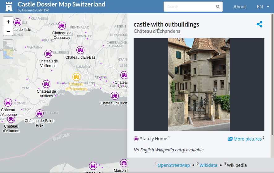
[1] The Institute for Software at the Technical University of East Switzerland (IFS OST) invites (Video) us to check out their video regarding mapping technology for the Castle Dossier Map The video forms part of an entry for the Prix Carto of the Swiss Society of Cartographers.
Jaisen Nedumpala reported on how he used OSM to help map a 3 km buffer zone during the recent Nipah virus outbreak in Kerala (India), with the personal support of Heinz_V from Germany and OSM contributors from Kerala.
switch2OSM
Sustrans, the UK cycling infrastructure charity, asked for local input for improving a national cycle route in the city of Durham. Gregory Marler’s (user livingwithdragons) advice, given somewhat tongue-in-cheek, was to switch to OSM.
Programming
The momepy Python library for analysing urban form is now at version 0.5.0. Of particular interest is the addition of the COINS algorithm for classifiying street hierarchies.
Did you know …
… what the charging regime is for using the HOT Tasking Manager? Also known as the Tasking Manager Sustainability Model.
… there is a page on the OSM Wiki for noting sites that use OSM but don’t provide correct attribution?
… that OpenCage post geographical trivia via Twitter on the last Friday of each month (hashtag #fridaygeotrivia)?
Other “geo” things
The Colorado Department of Transport falsely changed the status of an open road to closed, not only on their own site (albeit briefly), but directly on Google, Waze, TomTom and AppleMaps. A major highway Interstate-70 was actually closed due to mudslides, causing an increase in traffic on a minor road. The fictitious road closure was meant to discourage further traffic build-up.
Using the example of the ‘Chinese Name of Lidl’ Yunus reflected on the challenge for western companies to select a Chinese name for their brand.


Leave a reply