Jinal Foflia invited contributors to participate in some interesting mapping challenges in the Philippines and Malaysia. She suggested that new or experienced mappers put their mapping hats on and join the MapRoulette challenges.
The mapping contest to improve OSM road data in Russia (we reported earlier) is over; results with some stats are available on this page.
Mapping
An old forum thread concerning appropriate tags for populated places in Austria has been reanimated> . The original concern, back in 2015, was the promotion of most places in Salzburgerland to place=town. It appears that the tagging of some places is still contentious.
Voting on the following proposals has closed:
historic=creamery for an industrial building where butter, cheese or ice-cream was made from milk was approved with 12 votes for, 2 votes against and 1 abstention.
currency:crypto:*=yes,no, a currency key extension for cryptocurrency support was rejected with 22 votes for, 34 votes against and 2 abstentions. The rejection occurred despite the participation of cryptocurrency fans, often without substantial OSM experience.
boundary=border_zone was approved with 16 votes for, 0 votes against and 0 abstentions.
François Lacombe’s proposal on the new tag outlet=*, to map details of culverts or pipeline outlets releasing fluids, is open for voting until Thursday 11 November.
SK53 analysed and visualised, in a very descriptive way, the use of the tag natural=heath compared to a comprehensive habitat cover dataset for the whole of Wales.
Community
Mordechai23 showed, in a diary post, a collection of gifs illustrating the process he, and other mappers, used to redraw landuse, buildings, paths and other objects, both in his home city, Wrocław, and elsewhere in Poland.
Open Mapping Hub Asia Pacific by HOT has created a Facebook group.
Imports
Kai Poppe has outlined, on the wiki, preparations for an automated edit to update mapillary tags made obsolete by a software update (as we reported earlier). The plan is to update all mapillary tags from the old 22-character form to the new numeric IDs of version 4. The Wiki page will be used to track current statistics and any further plan of action.
There was also a MapRoulette challenge that sought to clean up all the invalid values, but it is now complete.
OpenStreetMap Foundation
At the Board’s request, the OSMF’s ban policy has been updated by the DWG with a new section ‘Blocks until a particular action has been taken’. This is largely documenting existing practice, but the Board felt that it was important the process was documented.
Local chapter news
Applications are now open for scholarships to attend the State of the Map US 2022 in Tucson, Arizona at the start of April.
Events
The Humanitarian Open Mapping Community Working Group by HOT invited>
Spanish-speaking local OSM community organisers, leaders and members (new and old) to come togetherand share their tips, tricks and challenges related to starting and sustaining local OSM communities on Monday 8 November at 16:00 UTC. Registeron Eventbrite if you wish to participate.
The theme of this year’s Genoa Science Festival (Italy) had ‘maps’ as its keyword. The Italian OSMF Chapter participated> both through a round table, in which four members of the community presented their professional activity involving OSM, and in a theatrical representation made by one of the winners of its ‘Free Theatre’ competition. Another presentation involving OSM was delivered by a team from Doctors Without Borders.
Maps
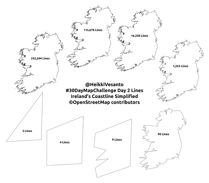
[1] The 30 Day Map Challenge (#30DayMapChallenge), which we reported last month, is now in full swing. Some examples of OSM-based maps from the first few days are:
Day 1 – Points: Bus stops in Bengaluru, by IamThiyaku. Every address in Garland County, Arkansas by Justin Myers.
Day 2 – Lines: Heikko Vesantu’s maps of Ireland proved very popular. They were made with progressively fewer lines (through simplification using the Douglas-Peucker algorithm).
OpenStreetMap Uganda tweeted maps showing the difference in accessibility of older sources of drinking water compared with new solar-powered ones. The work was done in collaboration with Water Compass.
Mateusz Konieczny spotted that Google Maps has public transport data for the Polish capital city of Warsaw. Mikołaj Kuranowski explained that he created the feed by combining data from the Warsaw transport authority and OSM for bus route topology. The correct attribution appears at the bottom of the panel showing a planned journey.
Mateusz Fafinski reviewed the recent Reddit map of castles in Europe by Spatial_Overlay, especially noting regional differences in OpenStreetMap tagging practices.
Software
Wille Marcel announced a new release of OSMCha. This version provides a better user experience on smartphones and tablets.
The Organic Maps project is looking for translators to help localise and maintain each language version.
Ilya Zverev described> the new OSMF Overpass server, which is dedicated to answering queries generated by the ↖? (Query Features) button on the main OSM website.
Programming
Digital artist JeongHo Park showcased an experimental visualisation of OpenStreetMap data on Twitter.
Brandon Liu, who has recently joined the Engineering Working Group, outlined why one cannot assume that OSM always uses Unicode.
Did you know …
… that it is possible to get free OSM advertising stickers and copyright banners?
Other “geo” things
In Atomos magazine, Ruth Hopkins surveyed the drive to restore indigenous topographic names in North America. Uldis Balodis pointed out, on Twitter, that this has resonances elsewhere, specifically in Baltic countries where they are involved in collecting Livonian place names.
Chronoscope World is a site for browsing historical maps.
Two unusual navigation errors were reported in Portugal this week. In one the driver of a car got stuck on>
a staircase, next to the Regional Legislative Assembly of Madeira, in Portugal. Apparently, the driver was misled by the GPS of the car, which told him to drive on.
In a second case, a driver crossed the D. Luís I Bridge> in Vila Nova de Gaia, Portugal, and entered a tunnel (TomTom) intended for the Porto Metro. The driver of the vehicle, 46 years old, said he did not live in the area and it was the GPS of the car that led him into the exclusive lane for the surface metro. Apparently, the navigation system used in the two cars involved is the TomTom system, which equips Renault brand vehicles.


Leave a reply