weeklyOSM 590

2021-11-12

02/11/2021-08/11/2021

Mapping

Community

  • Public Lab Mongolia have started a blog series. First up: ‘Creating An Open-Source Database To Improve Access To Health Services Amid COVID-19 Pandemic In Mongolia’.

  • OpenStreetMap Belgium’s Mapper of the Month for November is Dasrakel from Belgium.

OpenStreetMap Foundation

  • Michael Collinson, acting as facilitator, has published the official set of questions and instructions for board candidates. Candidates are asked to send answers and manifestos by 24:00 UTC, Sunday 14 November.

  • Amanda McCann informed the Osmf-talk mail list that the microgrants programme has been shelved while the Board works out the budgeting.

  • Amanda McCann shared, in her diary, what she did in OpenStreetMap during October.

  • This year’s OSMF Annual General Meeting has a special resolution to change the OSMF’s Articles of Association to count time as associate member for board candidacy requirements.

  • Instructions on voting at this year’s OSMF Annual General Meeting have been published.

OSM research

  • A dissertation by Filip Krumpe was published

    (de)
    >
    en
    at the University of Stuttgart that deals with the labelling of interactive maps. OSM data are used as the geodata basis. The thesis can be downloaded
    (en)
    as a pdf (file size: 29.1 MB).

  • Lukas Kruitwagen and colleagues at Oxford University published (paywall) a large worldwide dataset of predicted locations of solar power plants. The lead author has also written an accessible account. The work involved using machine learning based on a training dataset from solar farms mapped on OpenStreetMap around 2017. Satellite imagery from both SPOT and Sentinel-2 were used for both the initial training and creation of the predicted data.

Humanitarian OSM

  • The annual HOT Summit will be held on Monday 22 November as a virtual event, with the theme: ‘The Evolution of Local Humanitarian Open Mapping Ecosystems: Understanding Community, Collaboration, and Contribution’. Registration closes on Friday 19 November.

Maps

  • [1] Participants in the ‘30 Day Map Challenge’ on Twitter continued to make maps using OpenStreetMap data:

    • Day 3: Polygons. Angela Teyvi showed how how much detail exists for some buildings in Accra, Ghana.
    • Day 4: Hexagons. Hexbinning of bus stops in Accra also by Angela Teyvi. SIG UCA found some actual hexagons to map – lecture theatres in San Salvador, El Salvador.
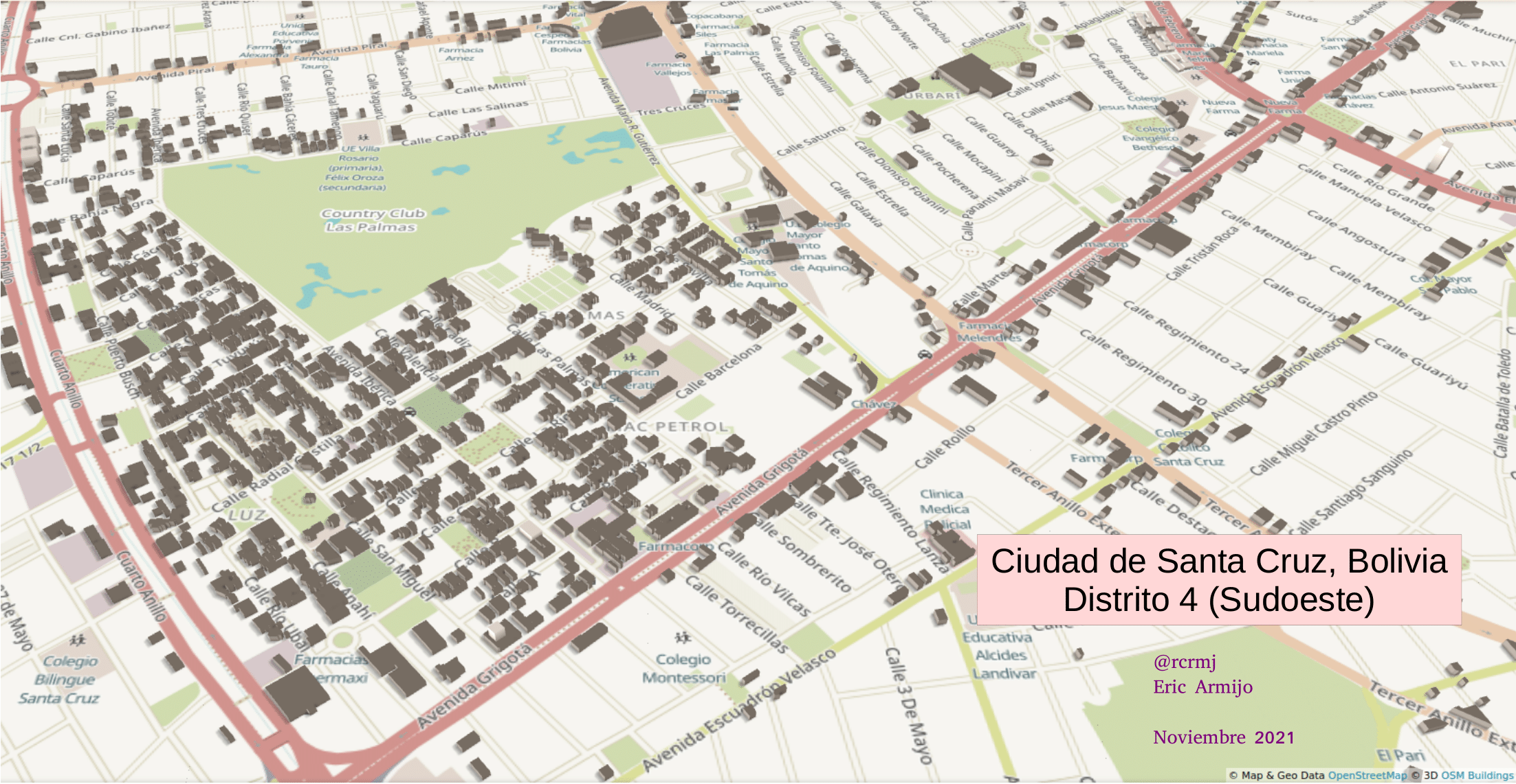
    • Day 5: Buildings in Santa Cruz, Bolivien by Eric Armijo.
    • Day 6: Red. Polluted lakes in Finland by Sini Pöytäniemi.
    • Day 7: Green. Shammilah showed isochrons of walking time to heatlh care facilites in Kisoro District, Uganda.
    • Day 8: Blue. Common choices were watery themes and places with blue in the name. Jaroslav_sm combined the two for lakes named ‘Blue Lake’ in Ukranian.
    • Day 9: Monochrome. Heikki produced an intriguing identification quiz on Irish towns and cities, based on buildings alone (cleverly leveraging and publicising the project to map them across Ireland).
  • Day 5 was a little special as OpenStreetMap was the theme. Many mappers chose to explore specific classes of objects: Sber offices in Moscow (Дмитрий); restaurants in Merced (Derek Sollberger); 7-11 convenience stores in Hong Kong (Brandon Qilin).

Xavier Olive did something a little different and explored the history of Zurich Airport on OSM.

Software

  • Mythic Beats hosting company donated two virtual servers to Organic Maps to help them distribute maps for offline usage on mobile devices. They point out that the apparently low value of their donation (in comparison to some other cloud service providers) is in part due to them not having to fund their own space programme.

  • TrackExplorer is software that allows you to upload a GPX file and visualise the trip in 3D. O J’s diary post gives some examples and notes that the base data is OSM, so the more accurate the data, the better the 3D environment displayed.

Programming

  • Komadinovic Vanja gave a whirlwind introduction to using OSM’s OAuth 2 authentication service.

  • Martin Raifer (user tyr_asd), the new iD developer contracted by OSMF, introduced himself.

Releases

  • Sarah Hoffmann presented version 4.0.0 of Nominatim, now available with a more flexible approach to handling how places can be searched.

Did you know …

  • … Open Etymology Map? It allows you to view and edit links to the Wikidata elements of people after whom a street is named.

  • … the polygon extractor of OSM France? This tool allows you to download OSM relations as GeoJSON, image and other formats based on the relations’ ID.

OSM in the media

  • The Economist covered (may be paywalled) the work of Kruitwagen and colleagues (reported above), including the role of OpenStreetMap data.

Other “geo” things

  • David Costa tweeted a link to a zoomable version of ‘Les grandes routes vélocipédiques de France’, an 1897 cycle touring map of France.

  • Niantic announced that the AR game ‘Harry Potter: Wizards Unite’ will cease to operate on 31 January 2022. The in-game map and data used to calculate monsters’ types and appearance rates are from OpenStreetMap.

  • User-contributed content added to Google Street View is causing players of GeoGuessr to get angry. As Andrew Deck explained players of GeoGuessr, an online game where you guess your randomly selected location based on street views, are unhappy with the grainy, blurry, or otherwise poor-quality uploads that slow them down.

  • grin wrote about his experiences with his real-time kinematic (RTK) configuration in search of the most accurate position (precise to within a few centimetres).

  • ARTE has a series (

    (fr)
    with
    (en)
    subtitles) of videos on ‘Mapping the World’. The series presents the complex world of geopolitics broken down into ten minute, bite-sized chunks. Allegedly ‘you’ll never sound uninformed at the dinner table ever again’.
Upcoming Events

WhereWhatOnlineWhenCountry
ЧеркасиOpen Mapathon: Digital Cherkasy ![osmcalpic](/wp-content/osmcal/favicon.png =16x16)2021-10-24 - 2021-11-20ua
Crowd2Map Tanzania GeoWeek FGM Mapathon ![osmcalpic](/wp-content/osmcal/favicon.png =16x16)2021-11-15
UP Tacloban YouthMappers: MAPA-Bulig, Guiding the Youth to Community Mapping ![osmcalpic](/wp-content/osmcal/favicon.png =16x16)2021-11-15
BolognaGeomatics at DICAM Geo Week Mapathon ![osmcalpic](/wp-content/osmcal/favicon.png =16x16)2021-11-15
GrenobleOSM Grenoble Atelier OpenStreetMap ![osmcalpic](/wp-content/osmcal/favicon.png =16x16)2021-11-15
OSMF Engineering Working Group meeting ![osmcalpic](/wp-content/osmcal/favicon.png =16x16)2021-11-15
Missing Maps PDX GIS Day Mapathon ![osmcalpic](/wp-content/osmcal/favicon.png =16x16)2021-11-16
UCB Brasil + CicloMapa: curso de mapeamento ![osmcalpic](/wp-content/osmcal/favicon.png =16x16)2021-11-16 - 2021-11-26
LyonLyon : Réunion ![osmcalpic](/wp-content/osmcal/favicon.png =16x16)2021-11-16
Bonn145. Treffen des OSM-Stammtisches Bonn ![osmcalpic](/wp-content/osmcal/favicon.png =16x16)2021-11-16
BerlinOSM-Verkehrswende #29 (Online) ![osmcalpic](/wp-content/osmcal/favicon.png =16x16)2021-11-16
LüneburgLüneburger Mappertreffen (online) ![osmcalpic](/wp-content/osmcal/favicon.png =16x16)2021-11-16
Missing Maps Arcadis GIS Day Mapathon ![osmcalpic](/wp-content/osmcal/favicon.png =16x16)2021-11-17
Fort CollinsCSU Geospatial Centroid GIS Day Mapathon ![osmcalpic](/wp-content/osmcal/favicon.png =16x16)2021-11-18
Missing Maps WMU GIS Day Mapathon ![osmcalpic](/wp-content/osmcal/favicon.png =16x16)2021-11-17
KölnOSM-Stammtisch Köln ![osmcalpic](/wp-content/osmcal/favicon.png =16x16)2021-11-17
ZürichMissing Maps Zürich November Mapathon ![osmcalpic](/wp-content/osmcal/favicon.png =16x16)2021-11-17
ChambéryMissing Maps CartONG Tour de France des Mapathons - Chambéry ![osmcalpic](/wp-content/osmcal/favicon.png =16x16)2021-11-18
MSF Geo Week Global Mapathon ![osmcalpic](/wp-content/osmcal/favicon.png =16x16)2021-11-19
State of the Map Africa 2021 ![osmcalpic](/wp-content/osmcal/favicon.png =16x16)2021-11-19 - 2021-11-21
Maptime Baltimore Mappy Hour ![osmcalpic](/wp-content/osmcal/favicon.png =16x16)2021-11-20
LyonEPN des Rancy : Technique de cartographie et d’édition ![osmcalpic](/wp-content/osmcal/favicon.png =16x16)2021-11-20
Bogotá Distrito Capital - DepartamentoResolvamos notas de Colombia creadas en OpenStreetMap ![osmcalpic](/wp-content/osmcal/favicon.png =16x16)2021-11-20
HOT Summit 2021 ![osmcalpic](/wp-content/osmcal/favicon.png =16x16)2021-11-22
BremenBremer Mappertreffen (Online) ![osmcalpic](/wp-content/osmcal/favicon.png =16x16)✓2021-11-22
San JoseSouth Bay Map Night ![osmcalpic](/wp-content/osmcal/favicon.png =16x16)✓2021-11-24
DerbyEast Midlands OSM Pub Meet-up : Derby ![osmcalpic](/wp-content/osmcal/favicon.png =16x16)2021-11-23
Vandœuvre-lès-NancyVandoeuvre-lès-Nancy : Rencontre ![osmcalpic](/wp-content/osmcal/favicon.png =16x16)2021-11-24
DüsseldorfDüsseldorfer OSM-Treffen (online) ![osmcalpic](/wp-content/osmcal/favicon.png =16x16)2021-11-24
[Online] OpenStreetMap Foundation board of Directors - public videomeeting ![osmcalpic](/wp-content/osmcal/favicon.png =16x16)2021-11-26
BrnoNovember Brno Missing Maps mapathon at Department of Geography ![osmcalpic](/wp-content/osmcal/favicon.png =16x16)2021-11-26
長岡京市京都!街歩き!マッピングパーティ:第27回 元伊勢三社 ![osmcalpic](/wp-content/osmcal/favicon.png =16x16)2021-11-27
Bogotá Distrito Capital - DepartamentoResolvamos notas de Colombia creadas en OpenStreetMap ![osmcalpic](/wp-content/osmcal/favicon.png =16x16)2021-11-27
泉大津市オープンデータソン泉大津:町歩きとOpenStreetMap、Localwiki、ウィキペディアの編集 ![osmcalpic](/wp-content/osmcal/favicon.png =16x16)2021-11-27
AmsterdamOSM Nederland maandelijkse bijeenkomst (online) ![osmcalpic](/wp-content/osmcal/favicon.png =16x16)✓2021-11-27
HOTOSM Training Webinar Series: Beginner JOSM ![osmcalpic](/wp-content/osmcal/favicon.png =16x16)2021-11-27
BiellaIncontro mensile degli OSMers BI-VC-CVL ![osmcalpic](/wp-content/osmcal/favicon.png =16x16)✓2021-11-27
ChamwinoHow FAO uses different apps to measure Land Degradation ![osmcalpic](/wp-content/osmcal/favicon.png =16x16)✓2021-11-29
OSM Uganda Mapathon ![osmcalpic](/wp-content/osmcal/favicon.png =16x16)2021-11-29
Missing Maps Artsen Zonder Grenzen Mapathon ![osmcalpic](/wp-content/osmcal/favicon.png =16x16)2021-12-02
BochumOSM-Treffen Bochum (Dezember) ![osmcalpic](/wp-content/osmcal/favicon.png =16x16)2021-12-02

This weeklyOSM was produced by Nordpfeil, PierZen, SK53, Strubbl, Andrew Davidson, cafeconleche, derFred.
We welcome link suggestions for the next issue via this form and look forward to your contributions.


Leave a reply

Comments loading…