weeklyOSM 607
01/03/2022-07/03/2022
Mapping campaigns
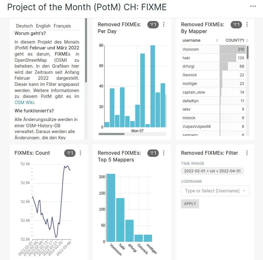
[1] Stefan Keller illustrated the Swiss project of the month > with sophisticated graphics.
Raphaelmirc reported > on the results of the Mapathon in City Xexéu, Brazil, and refers > to the website of UMBRAOSM, the organisation that arranges these Mapathons in Brazil.
Mapping
Enock Seth drew mappers’ attention to the updated Maxar Premium Imagery around Kumasi, Ghana on the Talk-gh mailing list and recommended how to work with the updated imagery.
On the German OSM forum, mappers discussed > the so-called ‘security vandalism’ in Poland and Ukraine. The term describes re-tagging or deleting military features. They concluded that it seems to be against the will of the community in Poland and such vandalism in Poland can and should be reverted without involving DWG.
Dakon has drafted a proposal for
railway:signal:height=*to map the height of all signals at a node that do not have a dedicated:height=*subtag.
Community
Amanda McCann issued her regular report covering her OSM activities for January 2022.
On Saturday 5 March the local chapter of YouthMappers in Guatemala held a basic OpenStreetMap workshop with the support of HOT and several universities in Guatemala.
OpenStreetMap Belgium’s Mapper of the Month for March is Søren Johannessen from Denmark.
On Saturday 26 February several people from Latin America participated in a ’note-a-thon’ (we reported earlier). User Mapeadora gave > her impressions of the event.
Local chapter news
- OpenStreetMap US published their March 2022 Newsletter.
Events
In commemoration of International Women’s Day, GeoChicas and YouthMappers held a virtual workshop on Thursday 3 March to provide training in technical tools to incorporate a city into the ‘Women’s Streets’ project.
On Tuesday 22 March the Trufi Association and the Institute for Transportation and Development (ITDP) will present a webinar on ‘Why Open Data Matters for Cycling’.
Education
In the eleventh part of her Derrynaflan Trail series, Anne-Karoline Distel showed how to 3D map a more complex building than a simple house: the Crohane Church.
Anne-Karoline Distel has also posted episode 12 of the Derrynaflan Trail on Youtube, showing how 3D models can be created from OSM data.
Humanitarian OSM
- Michael Montani, a GIS consultant for the UN Department of Operational Support, explained, on the HOT discussion list, how the UNSOS peacekeepers in Somalia are using OSM data to support their intervention. He also mentioned their concern about quality problems from some mapping projects located on the HOT Tasking Manager in areas with security problems that UNSOS monitors.
Alessandro, a UNMapper, already expressed his frustration about these quality problems (we reported earlier) two months ago. He continued in a new blog post, which triggered some comments suggesting that eventual intervention from the OSMF Data working group may be required.
- Bo Percival introduced the new members of the HOT tech team.
Software
- yuiseki has developed an online tool that visualises the editor of each building object on a map with user icons. The source code is available on GitHub.
Did you know …
… the various Geotools: ‘Reprojector’, ‘How Big’, ‘Gimme Geodata’ and ‘Radius’ of Hans Hack?
… that LeafletJS, an open-source JavaScript library for interactive maps, also mobile-friendly, was born in Ukraine 11 years ago?
… openSenseMap, the map with open sensor data? The senseBox offers students and interested citizens an OSM platform to collect and publish measurement data.
OSM in the media
The Register reported on the StreetComplete app being rejected from the Google Play Store due to it having a donation link.
Guillaume Rischard (OSMF Chair) created his own map of Kharkiv in half an hour to compare it with a publication in the NY Times. Result: ‘The New York Times did not use OpenStreetMap, but an inferior, probably commercial source. Otherwise their map would be better.’
Other “geo” things
In a Twitter thread, Mateusz Fafinski showed how cartographic choices in mapping the Russian invasion of Ukraine can influence our perceptions.
Dr. Jeffrey Lewis showed, on Twitter, how traffic information can be used to track military movements – hours before it was officially announced. Google reacted and deactivated the traffic layer for Ukraine.
Webcams on German motorways are currently offline. Some speculate that this is to limit open source intelligence (via Twitter ).
The UK Health and Safety Executive have created a database of fine-grained population estimates to assist in risk assessment; the National Population Database. A small sample of the database covering part of South Manchester is available online for interactive use. The types of data available (school enrolment, hospital beds, stadium capacity, etc.) may be of interest to OSM mappers.
Upcoming Events


This weeklyOSM was produced by Lejun, MatthiasMatthias, Nakaner, Nordpfeil, PierZen, SK53, Sammyhawkrad, Strubbl, Andrew Davidson, YoViajo, derFred, ztzthu.
We welcome link suggestions for the next issue via this form and look forward to your contributions.
Leave a reply