weeklyOSM 637
27/09/2022-03/10/2022
Mapping
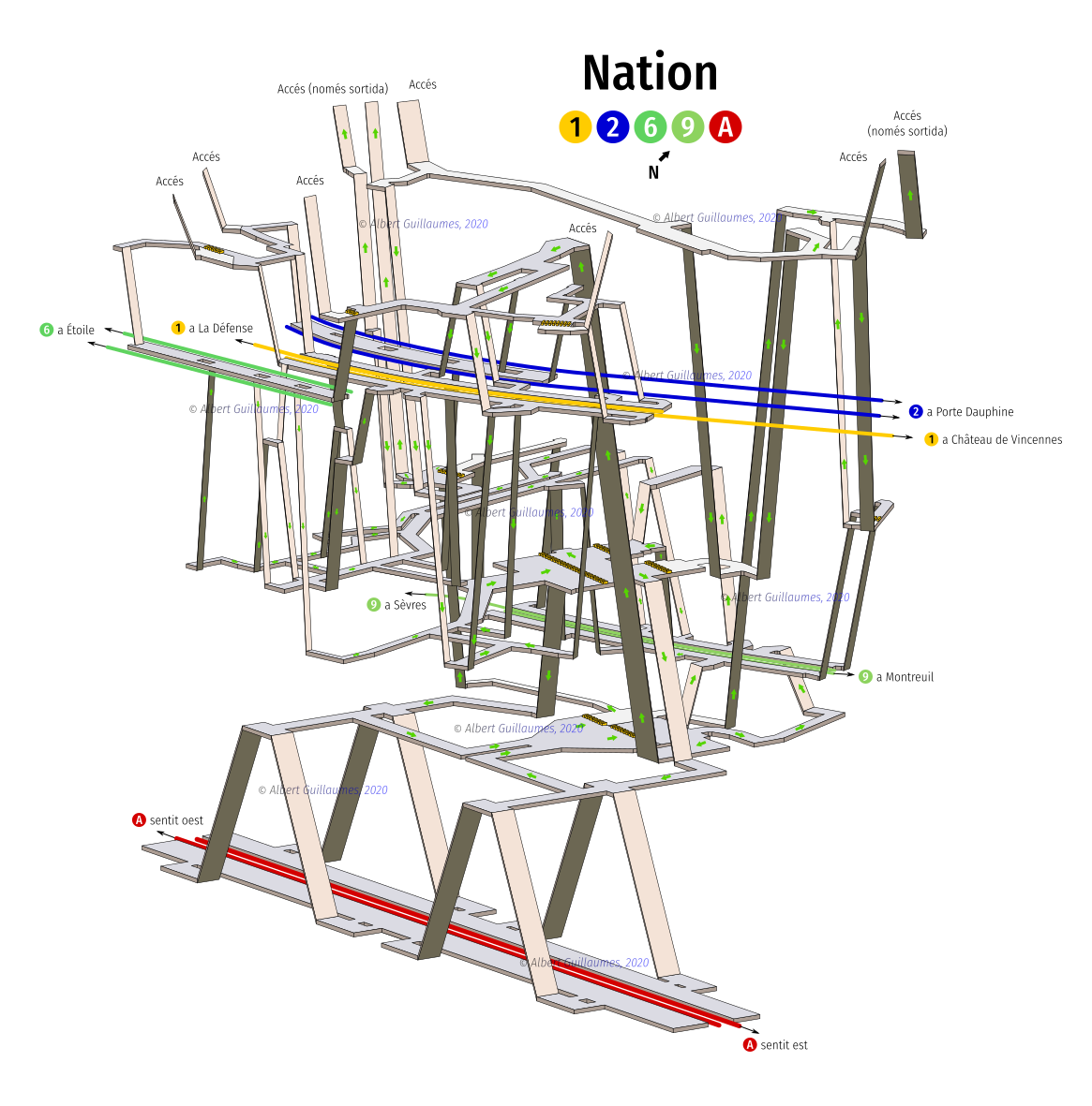
Albert Guillaumes Marcer published digitalised sketches of different metro station layouts around the world. Of interest to indoor mappers and transport nerds.
A request has been made for comments on the following proposal:
gender=*, a gender designation of the facility.
Voting on the following proposal has closed:
- clarifying the definition of the dimensional tags used on loading docks was approved with 17 votes for, 0 votes against and 0 abstentions.
Robhubi published ► a georeferencing tutorial using JOSM.
Community
The Heidelberg Institute for Geoinformation Technology (HeiGIT) is looking for an experienced software engineer in the field of OpenStreetMap Routing Services (Java backend).
The Trufi Association is hiring a part-time development/fundraising professional to help find new funding and projects for mapping public transport, open source apps, and open data. Applications by Saturday 15 October.
OpenStreetMap Commune of Pontarlier’s Twitter account discussed the importance of OpenStreetMap usage by the French tourism offices. Later, Antoine Riche pointed out carte.seignanx.com, a land mapping project carried by the Commune of Seignanx Tourist Office.
The UN and the EU have launched seven challenges around OpenStreetMap, running until the end of October. The challenges include using OpenStreetMap data to measure achievement on sustainable development goals, mixing OpenStreetMap and other open data, improving tools for mappers, and improving the OpenStreetMap website. There’s even a challenge to create a ‘News’ section to include weeklyOSM on openstreetmap.org! The EU will award a prize of €10000 to the best solutions.
OpenStreetMap Foundation
- The 16th Annual General Meeting of the OpenStreetMap Foundation (OSMF) will be held online in the #osmf-gm IRC chat room on Saturday 10 December 2022, 16:00 UTC. This meeting will have a board election, with three seats available. Voting for the board election will start one week before the annual general meeting.
Local chapter news
- OpenStreetMap US has released their September newsletter.
Events
GeomobLON was back in London. On Wednesday 28 September you could have listened to the following talks at geovation:
- Chris Brown – create maps much faster with mapstack.io
- Ben Abelshausen – how anyways.eu uses data from OpenStreetMap
- Pablo Viejo – applying AI-driven text recognition models with bettermaps.ai
- Chris Barrington Brown – maps used in preparation, training and during the 1944 Normandy landings
- Christian Nolle – his newspaper for airline maps called Direction of Travel.
And, as usual at such events, the second half with geobeers and discussion was very important to deepening the discussion of topics.
Maps
Paul McBurney Jr has built an interactive map to simulate asteroid impacts and to locate all major known asteroid collisions with Earth from the 18th century up to the present. The required OSM attribution is missing on both maps.
Maptiler Labs has created a ‘Lord of the Rings’ style world map.
Open Data
- Martijn van Exel explained how he uses the RapiD tool to add data from free and open sources to OSM.
Software
- The Goose Maps team shared their detailed story about building OSM-based offline maps on the Apple Watch platform.
Programming
Flo Edelmann is working on standardising the file extension for Overpass QL query files to
*.overpassql. The goal is to enable proper syntax highlighting on GitHub. If you know of such files in repositories not currently listed, please contact him.QwantMaps, a French Google environment alternative, now includes ► public transportation in its routing service in addition to car, foot and bicycle. While using OpenStreetMap for numerous things, the transportation data results from a collaboration with Hove, a part of Keolis, which in turn is a multinational transport company.
Releases
Did you know …
… there is a dashboard that allows you to track statistics on changes in OSM by changeset count ?
… the OpenInfraMap, an OpenStreetMap-based power and telecom infrastructure map?
… OSM Apps Catalog, a website to filter and search for OSM apps described in the OpenStreetMap wiki?
OSM in the media
Minds Behind Maps, a geospatial podcast sponsored by OpenCage, hosted an exclusive interview with Steve Coast, OpenStreetMap’s founder.
OpenStreetMap was featured on the HackerNews front page, generating tons of discussions.
The Financial Times published an interactive map to explain Ukraine’s counter-offensive in the north-east.
Other “geo” things
OpenCage explained several interesting facts about Germany’s borders, border disputes and exclaves in their #geoweirdness weekly thread.
The ‘web-based citizen social science project’ Colouring London published a map showing twelve categories of information about the buildings of London. They also have plans for other cities.
Google has announced a number of new features for Google Maps.
Channon Perry and her boyfriend analysed their personal GPS traces to find ‘missed potential fateful encounters’ in the past.
Arnaitz Fernández highlighted the difference in lighting before and after Hurricane Ian hit Florida.
Upcoming Events
| Where | What | Online | When | Country |
|---|---|---|---|---|
Hacktoberfest 2022  | 2022-10-01 - 2022-10-31 | |||
| United Nations - OSS4SDG: Smart Sustainable Cities Hackathon | 2022-10-03 - 2022-10-31 | |||
| Washington | MappingDC Mappy Hour | 2022-10-12 |  | |
| München | Münchner OSM-Treffen | 2022-10-11 |  | |
| San Jose | South Bay Map Night | ✓ | 2022-10-12 | |
| HOT Tasking Manager Monthly Meet Up | 2022-10-12 | |||
| Berlin | Missing Maps - DRK Online Mapathon | 2022-10-12 | | |
| Montrouge | Réunion des contributeurs de Montrouge et du Sud de Paris | 2022-10-13 |  | |
| Frankfurt am Main | Arbeitstreffen Indoor OSM 2022 | 2022-10-14 - 2022-10-16 | | |
| Berlin | 172. Berlin-Brandenburg OpenStreetMap Stammtisch | 2022-10-14 | | |
| Hlavní město Praha | World Railway Mapping Online Quarterly Meetup. | 2022-10-15 |  | |
| Guapimirim | Mapeamento da Cidade de Guapimirim - Rio de Janeiro (RJ) Brasil. | 2022-10-17 - 2022-10-18 |  | |
| Grenoble | Réunion mensuelle du groupe local OSM Grenoble | 2022-10-17 | | |
| Lyon | Rencontre mensuelle Lyon | 2022-10-18 | | |
| 156. Treffen des OSM-Stammtisches Bonn | 2022-10-18 | |||
| City of Nottingham | OSM East Midlands/Nottingham meetup (online) | ✓ | 2022-10-18 |  |
| Lüneburg | Lüneburger Mappertreffen (online) | 2022-10-18 | | |
| Sélestat | Rencontre des contributeurs.rices en Alsace | 2022-10-19 | | |
| Roma | Incontro dei mappatori romani e laziali - ottobre 2022 | 2022-10-19 |  | |
| Karlsruhe | Stammtisch Karlsruhe | 2022-10-19 | | |
| Zürich | Missing Maps Zürich Mapathon | 2022-10-19 |  | |
| Arlon | EPN d’Arlon - Atelier ouvert OpenStreetMap | 2022-10-20 |  | |
| Berlin | Berliner OSM Hackweekend | 2022-10-22 - 2022-10-23 | | |
| Rapperswil-Jona | OSM-Stammtisch | 2022-10-25 | | |
| San Jose | South Bay Map Night | ✓ | 2022-10-26 | |
| [Online] OpenStreetMap Foundation board of Directors - public videomeeting | 2022-10-27 | |||
| City of New York | New York City Meetup | 2022-10-29 | |
This weeklyOSM was produced by Lejun, Nordpfeil, PierZen, Strubbl, Andrew Davidson, derFred, jcr83, mvexel, rtnf.
We welcome link suggestions for the next issue via this form and look forward to your contributions.
Leave a reply