weeklyOSM 647
06/12/2022-12/12/2022
Breaking news
- Four major companies, two of whom are corporate members of the OSMF, in conjunction with the Linux Foundation have announced a new open map platform, Overture Maps. Map data will, in part, be based on OSM with other data from other open sources. We will provide more detail on this development and reactions next week.
Mapping
Jake Coppinger demonstrated how it is possible to use a 360 degree camera and OpenDroneMap to produce point clouds, which are an adequate alternative to aerial imagery.
Kai Johnson described how to work with the US National Hydrography Dataset for mapping waterways and also elaborated on its limitations.
LySioS explained ► the various sources of open address data in France, and then proceeded to provide a detailed approach to using local address data at the commune level (BAL) to populate OSM.
Christoph Hormann (imagico) announced the availability of additional imagery layers of Antarctica, for those interested in mapping the continent in OpenStreetMap.
The proposal made by Phispi for the tag
type=sled, to tag a sled run, is waiting for your comments.Voting on the proposed new schema for mapping street parking spaces has closed. It was approved with 51 votes for, 2 votes against and 1 abstention.
OpenStreetMap Foundation
The 2022 Annual General Meeting of the OpenStreetMap Foundation was held on Saturday 10 December. The main business items at the meeting were various reports from directors and some working groups, and the election of new board members. Four new board members were elected. In alphabetical order:
- Craig Allan
- Sarah Hoffmann
- Mateusz Konieczny
- Arnalie Vicario
Board reports included:
Chairperson’s report from Guillaume Rischard, the outgoing chair.
Treasurer’s report from Roland Olbricht, consisting of the formal accounts for 2021 (also available here) and preliminary accounts for 2022 year-to-date.
Reports from the newly renamed Financial Working Group (formerly the Fundraising Working Group), and the Personnel Committee.
Dorothea, the OSMF’s administrative assistant, provided a breakdown of OSMF members eligible to vote in the board elections this year. Overall numbers are unchanged from 2021, but there was a decline in membership in the Asia-Pacific region, and a big drop-off, from a very small base, in the Middle Eastern region.
Events
- BenHur tooted a thread reporting on the PistaNgMapa conference, which incorporated State of the Map Asia 2022.
Education
Anne-Karoline Distel (b-unicycling) provided the fifth instalment of her YouTube series on mapping crannógs. This time, making use of crannóg images on WikiCommons (mainly from the Geograph site).
Narayan Thapa summarised a study that used drones to map the current state of rooftop farming in Banepa Municipality (Nepal) and estimated the area for future farming.
OSM research
The research paper ‘De/colonizing OpenStreetMap? Local mappers, humanitarian and commercial actors and the changing modes of collaborative mapping’, by Susanne Schröder-Bergen, Georg Glasze, Boris Michel and Finn Dammann, observes conflicts but also collaborations between OSM communities of local craft mappers and large economic and humanitarian actors. It tries to interpret these changes in OSM and proposes two ostensibly contradictory, but ultimately intertwined, interpretations of the processes described.
Springer have published a new book Open Mapping towards Sustainable Development Goals. The editor is Patricia Solis, with individual chapters written by members of YouthMappers, and it is available free of charge as a PDF.
Maps
Stamen reviewed how their basemaps have been used in the #30daymapchallenge. Of broader interest in the blog post, spotted by kgjenkins on Mastodon, is that Stamen will stop supporting these maps directly in the near future. People who have ideas on how the maps can have a future are asked to get in touch with Stamen.
watmildon has created a map showing the number of buildings without addresses in order to identify regions of interest for further mapping activities.
switch2OSM
- Mishari described a group, ปั่นต่อ (Puntor), that is collecting data on behalf of the Deputy Governor of Bangkok, which aims to improve active mobility (cycling and walking). The Thai OSM community has produced some isochrons for these activities from OSM, which has elicited positive responses.
Licences
- The Bavarian mapping institute is suing ► Michael Kreil because he used their data to create maps of the potential for wind turbines in Germany based on the most liberal regional laws (Niedersachsen) and the most restrictive (Bayern). The Bavarian law apparently only allows new wind turbines when they are at least 10 times their height distant from residential properties.
Software
- A video showing results from the UN/EU sponsored hackathon on Sustainable Cities and Communities is available on YouTube.
Programming
Sarah Hoffman (lonvia) described how the frontend of Nominatim will now be rewritten in Python from the current PHP whilst also introducing significant enhancements. A major change will allow a local Nominatim instance to be run without a web server. The work is supported by NGI0 Entrust.
Jon Dalrymple reported, on the OSM Community forum, that they have been developing an open source project which uses machine learning to classify road surface from a US government imagery source (NAIP). When compared to a random selection of OSM ways with a surface tag it exceeds 80% agreement. Although there are some dissenters, this approach offers the possibility of greatly improving information on rural roads in the ‘flyover states’, which are often still unimproved TIGER imports.
The OSM Operations Team reminded users to ensure they are using the public URL to access the tile server tile.openstreetmap.org (we reported earlier). The old references that need to be converted are listed on GitHub.
Releases
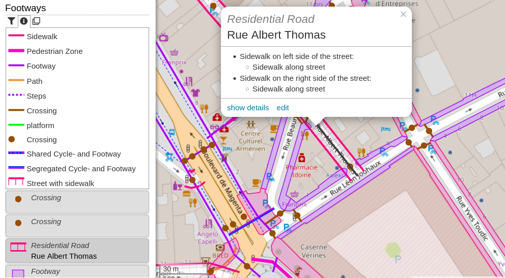
[1] Stephan Bösch-Plepelits (skunk) has announced there is a new footways category in OpenStreetBrowser. This shows footways, sidewalks (mapped as ways or tags on roads), steps and pedestrian areas. The overlay is discussed on the OSM community forum.
OsmAnd has released version 4.3, which comes with a lot of new features and updates, including a weather plugin and a new default rendering engine for Android and iOS. ‘OsmAnd Pro’ and ‘Maps+’ subscription plans have been introduced. Active OSM contributors will continue to get unlimited map downloads for free.
Did you know …
- … that you can find the centroid of an OSM element using the Python program outlined by mcepl in their diary entry?
OSM in the media
- The student media group Megabyte wrote ►, in an article on the benefits of AI, about the RapiD editor, which has helped the HOT project.
Other “geo” things
- The Economist discussed how streets are named in Europe. The article was prompted by an academic analysis of street names in four European cities, which used data from Wikipedia and Wikidata, but not OSM’s
name:etymology.
Upcoming Events
| Where | What | Online | When | Country |
|---|---|---|---|---|
| Toulouse | Réunion du groupe local de Toulouse  | 2022-12-17 |  | |
| London | London xmas pub meet-up | 2022-12-19 |  | |
| OSMF Engineering Working Group meeting | 2022-12-19 | |||
| Bruxelles - Brussel | OpenStreetMap meetup in Brussels | 2022-12-20 |  | |
| Lyon | Rencontre mensuelle Lyon | 2022-12-20 | | |
| 158. Treffen des OSM-Stammtisches Bonn | 2022-12-20 | |||
| Lüneburg | Lüneburger Mappertreffen (online) | 2022-12-20 |  | |
| Karlsruhe | Stammtisch Karlsruhe | 2022-12-21 | | |
| Düsseldorf | Düsseldorfer OpenStreetMap-Treffen | ✓ | 2022-12-30 | |
| City of Westminster | Missing Maps London Mapathon | 2023-01-03 | | |
| Stuttgart | Stuttgarter Stammtisch | 2023-01-03 | |
This weeklyOSM was produced by 38446, Elizabete, MatthiasMatthias, Nordpfeil, PierZen, SK53, Sammyhawkrad, Strubbl, Andrew Davidson, TrickyFoxy, derFred, muramototomoya.
We welcome link suggestions for the next issue via this form and look forward to your contributions.
Leave a reply