weeklyOSM 663
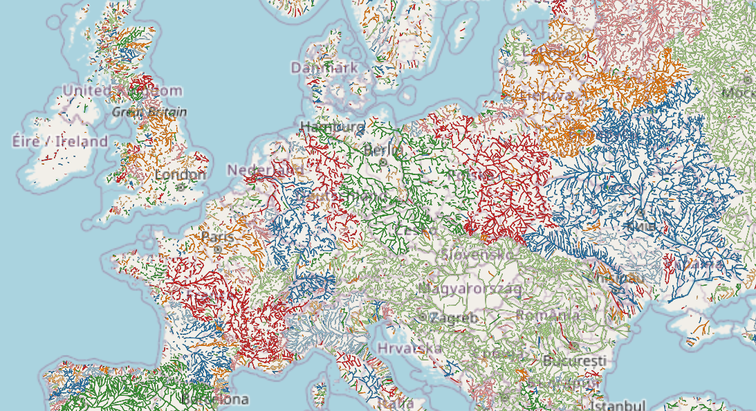
River basins calculation in Europe, based on connected ways data from OpenStreetMap.
© Amanda McCann | map data © OpenStreetMap contributors
28/03/2023-03/04/2023
Mapping
Andres Gomez Casanova reviewed ► the different services and websites that are available to capture and store geo-referenced street-level photos in the world. Some of them, such as Mapillary, KartaView and Mapilio, allow the use of the images for OSM mapping.
CactiStaccingCrane has started mapping the forest in the Mường Tè district of the Lai Châu province. The reason is that most of Vietnam is covered with forest and there is practically no good data in Vietnam that is suitable for import. However, he also doesn’t want to spend many more months negotiating data access with the government or organisations to improve forest mapping coverage.
chris_debian noted 14 requirements in his ‘Thoughts on collecting road surface information’, especially for cyclists. He classified the requirements into: M=‘Must Have’, S=‘Should Have’, C=‘Could Have=’, W=‘Won’t Have’ (usually known as the MoSCoW method).
chris66 presented ► three new 3D buildings in his blog post.
EdoBoo demonstrated skillful micro-mapping using the example of Petronas International near Turin.
Rabi Shrestha described how he performs field data collection and thereby ensures data quality in OSM.
Voting on the proposal for a guide to classifying roads in Louisiana has started and will end on Wednesday 12 April.
Events
The 2023 FOSSGIS conference in Berlin was a huge hit. The organisation has posted ► a retrospective with pictures and quick statistics on their website.
HeiGIT has co-organised the upcoming GIScience colloquium ‘Advancing urban modelling with emerging geospatial datasets and crowdsourcing’ to be given by Dr. Filip Biljecki of the National University of Singapore. The colloquium will take place in Heidelberg in the Hörsaalzentrum Chemie, Hörsaal West, INF 252 on Monday, 24 April 2023, at 10 a.m. Much of the work is focused on OpenStreetMap and other VGI (Volunteered Geographical Information). The talk will cover recent investigations on data quality, data gaps, and understanding contributors.
Humanitarian OSM
Samson Ngumenawe blogged about a tool under development to improve data quality for the HOT Open Mapping Hub – Asia-Pacific.
Delphine Montagne looked ► back at the different stages of HOT OSM data validation in order to guarantee its quality (with wonderful illustrations).
Maps
Geofabrik, which offers daily updates of OSM data by country, has started making experimental vector tile packages available on their download server.
Amanda McCann tooted, on Mastodon, a river basin map that uses OSM data. The source is available on GitHub.
Walter Nordmann (Wambacher) has created a postcode map for Germany. It is intended to be used for quality analysis and troubleshooting.
Clay Smalley posted an April Fool’s joke on the OSM Community forum.
Supaplex found blurred but still recognisable examples of the OpenStreetMap Carto style in a discussion thread by Taiwan Infantry Command officers on the Taiwan BBS PTT military board.
timethy96, from TheMoMStudio, has published the web app swzpln.de / opencityplans.com . It offers free access to map material. In addition to figure-ground diagrams, thematic layers such as forests or bodies of water can also be added.
Software
- Are you looking for an OSM-based vector map for cycling with turn-by-turn directions, quiet road/trail guidance, and many more details for your iPhone? Richard Fairhurst has delivered it to you. An Android version should also be available soon.
Programming
- Kai Johnson described in detail the hardware and software requirements for building a personal Overpass server on a tiny budget. mmd commented on some of Kai’s discoveries and reminded people that Overpass questions can be asked on the OSM Community forum using an ‘overpass’ tag, or on the OSM US Slack.
Releases
OsmAnd 4.4 for Android and iOS was released on 1 April. For Android users tracks can be customised, localised POI names are available, and routes can be shared by link. For iOS CarPlay has been enhanced, hiking routes can be selected on the map, and tracks can be uploaded to OSM.
Richard Fairhurst announced the release of Tilemaker v2.4. Tilemaker is a command-line utility that takes OpenStreetMap data in PBF format and makes vector tiles out of it. The release mainly optimises the speed of the tool.
Did you know …
- … that osm2pgsql is gradually transitioning from the use of hstore to json for storing tags?
OSM in the media
The Polish computer portal Pure PC recommended ► alternatives to Google Maps. Many of them are based on OpenStreetMap.
An expert policy discussion was held jointly by the Jeju Island authority and South Korea Ministry of Land, Infrastructure, and Transport to introduce the concept of ‘15-minute cities’ across the island. During the discussion Kim Seonghun, team leader of the Jeju Island Urban Regeneration Support Centre, emphasised the importance of OpenStreetMap as a participatory open-source mapping platform for the foundation of pedestrian-oriented cities.
Other “geo” things
The Canada Bay Council in Sydney, Australia plans to remove the Heath Street cycleway due to a misleading traffic report.
HeiGIT participated in the second UN Maps Conference. Using their practical experience in working with open data, Professor Alexander Zipf and Benjamin Herfort joined in vital discussions around how to ‘build greater UN Maps’ based on open source software and open data. The conference made clear that most mapping and geospatial analysis carried out by UN organisations such as UNICEF, FAO, WHO and WFP would not be possible if OSM data didn’t exist.
The Economist looked at the future of city grids, making extensive use of the work of Geoff Boeing (on which we have reported previously).
Most cities do not map their own pedestrian networks. Now researchers have developed the first open-source tool to let planners do just that. MIT researchers have developed TILE2NET, an open-source tool that uses aerial imagery and image recognition to create complete maps of pavements (sidewalks) and pedestrian crossings.
Upcoming Events
| Where | What | Online | When | Country |
|---|---|---|---|---|
| Gramado | Gramado-(RS) Mapeamento de Edifícios com dados da Microsoft e Editor RapiD.  | 2023-04-08 |  | |
| København | OSMmapperCPH | 2023-04-09 |  | |
| 臺北市 | OpenStreetMap x Wikidata 月聚會 #51 | 2023-04-10 |  | |
| HOT Open Tech and Innovation WG | 2023-04-11 | |||
| Zürich | OSM-Stammtisch | 2023-04-11 |  | |
| München | Münchner OSM-Treffen | 2023-04-11 |  | |
| Formação UN Mappers: OpenStreetMap e o mapeamento humanitário - sessão 4 | 2023-04-12 | |||
| Zaragoza | Mapatón Humanitario (Médicos Sin Fronteras + Universidad de Zaragoza + Mapeado Colaborativo / Geoinquietos Zaragoza) | 2023-04-12 |  | |
| Salt Lake City | OSM Utah Monthly Map Night | 2023-04-13 |  | |
| IJmuiden | OSM Nederland bijeenkomst (online) | 2023-04-12 |  | |
| Southeast | FOSSASIA | 2023-04-12 - 2023-04-14 | sg | |
| Olomouc | Dubnový olomoucký mapathon - hybridní | 2023-04-13 |  | |
| Localidad Usaquén | GeoBeer - Reunámonos con una cerveza para hablar de OpenStreetMap | 2023-04-14 |  | |
| Jaro | #MapaTime with Central Phillippines University, Iloilo | 2023-04-14 |  | |
| Grenoble | Mapathon CartONG | 2023-04-14 |  | |
| Berlin | OSM Stammtisch Berlin/Brandenburg | 2023-04-14 | | |
| Berlin | OSM Hackweekend Berlin 04/2023 | 2023-04-15 - 2023-04-16 | | |
| Caen | Carto Party Vélo | 2023-04-15 | | |
| Toulouse | Réunion du groupe local de Toulouse | 2023-04-15 | | |
| Rio de Janeiro | Mapeamento com OpenStreetMap | 2023-04-15 | | |
| Hannover | OSM-Stammtisch Hannover | 2023-04-17 | | |
| Grenoble | Atelier adressage dans OpenStreetMap | 2023-04-17 | | |
| 6th Annual Humanitarian Mapathon / 6. jährlicher humanitärer Mapathon / 第6回ヒューマン・マパソン | 2023-04-18 - 2023-04-20 | |||
| OSMF Engineering Working Group meeting | 2023-04-18 | |||
| Lyon | Réunion du groupe local de Lyon | 2023-04-18 | | |
| Bonn | 162. Treffen des OSM-Stammtisches Bonn | 2023-04-18 | | |
| Lüneburg | Lüneburger Mappertreffen (online) | 2023-04-18 | | |
| Formação UN Mappers: OpenStreetMap e o mapeamento humanitário - sessão 5 | 2023-04-19 | |||
| HOT Open Tech and Innovation WG | 2023-04-19 | |||
| Berlin | Missing Maps - DRK & MSF Online Mapathon | ✓ | 2023-04-19 | |
This weeklyOSM was produced by ChristopherGS, HeiGIT, MatthiasMatthias, SK53, Strubbl, Andrew Davidson, YoViajo, barefootstache, derFred, renecha.
We welcome link suggestions for the next issue via this form and look forward to your contributions.
Leave a reply