weeklyOSM 671
23/05/2023-29/05/2023
Mapping
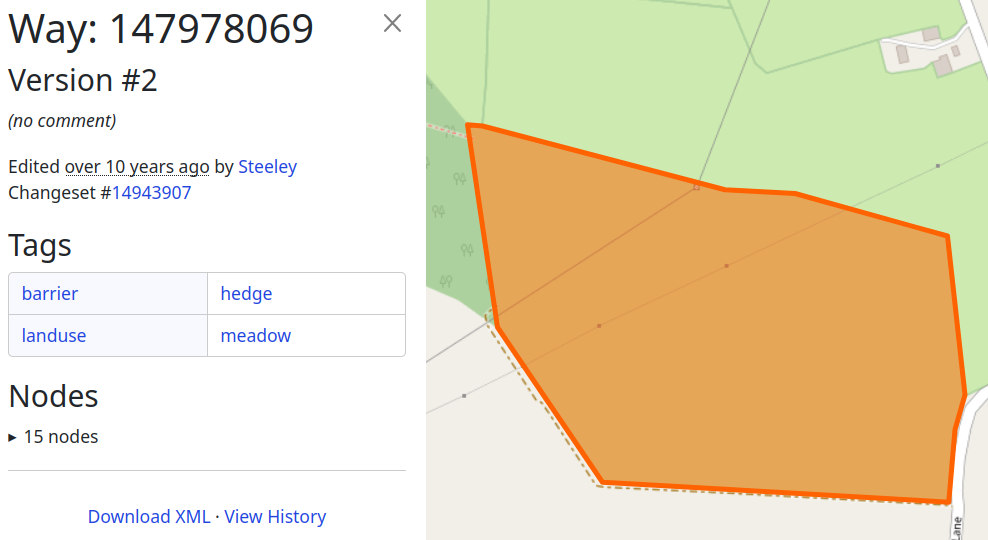
[1] Andy Townsend explained on his blog that hedges in OpenStreetMap can be lines or polygons and goes into detail concerning the benefits and drawbacks of each mapping approach.
The Champs-Libres team wrote about their collaboration with the national railway company of Belgium, NMBS/SNCB, to enhance the quality and comprehensiveness of information about the stations and their accessibility for travelers, especially cyclists (stations, platforms, accessibility and services). One specific objective is to identify missing platforms and assist in mapping stations where this information is absent.
Can Ünen (unen) shared how shadows can help in telling constructed ponds from buildings in his tweet and calls for action on a small pond mapping project in Karnataka, India.
Nick Johnston wondered if there is a tag for mapping off-road wheelchair accessibility.
Wilmer Osario described ►, in great detail with nice illustrations, his method of mapping the forest cover (
natural=wood) of a mountain range, using JOSM and Maxar.A request has been made for comments on
playground=*, a proposal to add values to the list of documented playground equipment.
Mapping campaigns
Every Sunday Mikko, from HOT Open Mapping Hub Asia Pacific, will host a voluntary mapping session using MapRoulette.
The Nigeria OSM community announced that they have moved from their virtual national monthly mapathon to weekly events.
Community
OpenMapChile uses OpenStreetMap data to calculate the distribution of Jubaea chilensis (Chilean wine palm) trees in Chile.
João Pedro de Andrade Eduardo, from Brazil, is the UN Mapper of the Month for June.
OpenStreetMap Foundation
- Mikel Maron, Guillaume Rischard, and Arnalie Vicario, representatives of the OpenStreetMap Foundation Board, will be holding a Q and A session at the State of The Map US event on 9 June 2023. This session will address the topic of ‘fundraising for OpenStreetMap’.
Events
There’s less than a week left to register for the State of the Map France 2023 conference, to be held in Marseille from 9 to 11 June. On Saturday 10 June at 4 pm CET (GMT+2), there will be a special question-and-answer session on Overture Maps with Simon Hughes, Head of Legal at TomTom. The session will be recorded and made available on Peertube, like most of the other sessions.
From Wednesday 7 to Friday 9 June, the UN Mappers team will be running an event to enhance the map quality and address road connection issues in Eastern DRC using MapRoulette. On Wednesday, to kick off the event, there will be three short introductory sessions in English, French, and Portuguese, in which the basics of how to tackle the challenge will be explained.
Maps
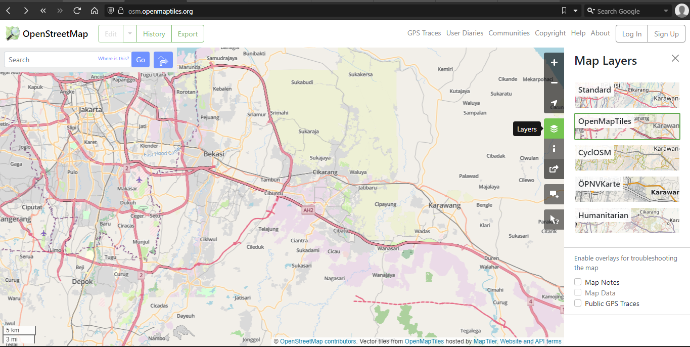
Martin Ždila opened a pull request to add OpenMapTiles vector tiles as one of the map layers on the openstreetmap.org website. Currently, this pull request is undergoing review by the OSM Operations Working Group. The demo page can be seen here (click on the ’layers’ icon, then activate ‘OpenMapTiles’).
Christoph Hormann (imagico) described, in his blog, an update of the general map rendering demonstration on maps.imagico.de including relief, hydrographic networks, and bathymetric rendering of seas.
Jake Coppinger tooted that he started a side project over the weekend – a map of how long pedestrians have to wait at traffic lights in Sydney, so as to identify problematic intersections. The results collected so far can be viewed on a map.
Open Data
- The data on the Bavarian Open Data Portal under CC BY 4.0 has been available ► for mapping in OSM since the beginning of 2023.
Software
MapLibre released their 2023 strategic plan.
Apache Baremaps, software for managing map servers based on vector tiles, has been released.
You can help MapSwipe redesign their website.
Tracestrack has published OpenStreetMap Routes Index, an open source Hugo-based website listing routes organised by countries. Examples: All subways in New York, Radial Expressways in Beijing. The project is looking for contributors to maintain route listings for each country.
Paul Norman has added functionality to tilelog to generate per-country usage information of the OSMF Standard Map Layer. The output of this is a CSV file, generated every day, which contains the country code, number of unique IPs that day, tiles, and cache misses per second. He has used the data of the first four months of 2023 to create two graphs.
Programming
HeiGIT, in part 15 of the ohsome series, analysed the mapping done in OSM after the earthquakes in Syria and Turkey in February 2023, using three different approaches. The results showed the amount of data contributed in OSM following the earthquake as well as which regions experienced the most intensive mapping activity.
Sarah Hoffmann wrote about refreshing the search algorithms being used in Nominatim and how the Python rewrite is allowing readjustments of the algorithm for improved matching.
Releases
OpenMapTiles version 3.14 has been released and has a lot of improvements. There is a new map style, which is inspired by OpenStreetMap. You can now see parcel lockers, shrubberies, bus guideways, and quarries as features on the map. The presentation of land use and land cover information has been improved on zoomed-out maps.
OpenSnowMap.org now includes some more high-precision relief generated from open datasets.
Vespucci 19.0 has been released and the privacy statement has been updated.
Did you know …
- … the Sketch Map Tool ‘for participatory sketch mapping through offline collection, digitisation, and georeferencing of local spatial knowledge’?
Other “geo” things
In a series of posts HeiGIT is looking back at some of their team’s contributions to Topi Tjukanov´s November Twitter event #30DayMapChallenge. First up is Jakob Schnell, who created raster, minimal and fantasy maps for the challenge.
On Friday 26 May, France and the Netherlands signed ► an agreement to settle a border dispute on the island of Saint-Martin in the West Indies. It is now clear that the border runs through the middle of Oyster Pond Bay. Fun fact, the photo in the article mistakenly shows Anse Marcel, which is located in the northern part of the island.
Upcoming Events
| Where | What | Online | When | Country |
|---|---|---|---|---|
| Bologna | Alluvione dell’Emilia-Romagna: editathon e mapping party al Salaborsa Lab  | 2023-06-03 |  | |
| Mosquera | Mapea por Mosquera | 2023-06-04 |  | |
| Mosquera | Resolución de notas en tiempo real - Real-time note resolution | 2023-06-04 | | |
| MapRoulette Nights | 2023-06-04 | |||
| 臺北市 | OpenStreetMap x Wikidata 月聚會 #53 | 2023-06-05 |  | |
| MapRoulette Monthly Community Meeting | 2023-06-06 | |||
| San Jose | South Bay Map Night | ✓ | 2023-06-07 |  |
| Missing Maps London Mapathon | 2023-06-06 | |||
| OSM-Verkehrswende #48 | 2023-06-06 | |||
| Stuttgart | Stuttgarter Stammtisch | 2023-06-07 |  | |
| Richmond | State of the Map United States 2023 | 2023-06-08 - 2023-06-11 | | |
| Rīga | State of the Map Baltics 2023 | 2023-06-08 - 2023-06-09 |  | |
| Windsor | MapRoulette-A-Thon | 2023-06-09 |  | |
| München | Münchner OSM-Treffen | 2023-06-08 | | |
| Marseille | State of the Map France 2023 | 2023-06-09 - 2023-06-11 |  | |
| Berlin | 180. Berlin-Brandenburg OpenStreetMap Stammtisch - 15 Jahre - mit der Wikipedia-Community | 2023-06-09 | | |
| Zürich | OSM-Stammtisch | 2023-06-10 |  | |
| Hannover | OSM-Stammtisch Hannover | 2023-06-10 | | |
| København | OSMmapperCPH | 2023-06-11 |  | |
| MapRoulette Nights | 2023-06-11 | |||
| Bari | FOSS4G-it 2023 | 2023-06-12 - 2023-06-17 | | |
| no location | Announcement of SotM Asia 2023 winning bid + recruitment of support from global community | 2023-06-12 | ||
| OSMF Engineering Working Group meeting | 2023-06-14 | |||
| Stainach-Pürgg | Neunter Österreichischer OSM-Stammtisch (online) | ✓ | 2023-06-14 |  |
| Salt Lake City | OSM Utah Monthly Map Night | 2023-06-15 | | |
| Eti Osa | Open Source for Good with Open Street Maps | 2023-06-15 - 2023-06-17 | ng | |
| Köln | Missing Maps Mapathon meets Medex | 2023-06-15 | | |
| Kaiserslautern | OSM Mapping Event Erfassung von Barrieren | 2023-06-17 | | |
| City Of Cockburn | Social Mapping Saturday: Port Coogee | 2023-06-17 |  | |
| Toulouse | Réunion du groupe local de Toulouse | 2023-06-17 | |
This weeklyOSM was produced by HeiGIT, MatthiasMatthias, PierZen, Strubbl, Andrew Davidson, adiatmad, barefootstache, derFred, renecha, rtnf.
We welcome link suggestions for the next issue via this form and look forward to your contributions.
Leave a reply