weeklyOSM 709
15/02/2024-21/02/2024
Mapping
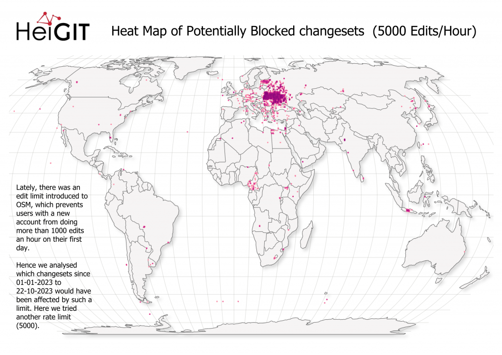
[1] Benjamin Herfort, from HeiGIT, has updated his analysis of the OSM contributors who would have run into OSM upload limits between January and October 2023 if the limits had existed back then. The updated version takes the (self-)deleted user accounts (usually vandalism related to the Ukraine/Russia and Israel/Palestine conflicts) into account. There was also a discussion on the OSM Community forum.
Jiri Podhorecky has created ► an environmental thematic map of the town of Český Krumlov, Czechia, by using uMap.
Requests for comments have been made for the following proposals:
traffic_sign=*an extended and advanced scheme to tag all kinds of traffic signs.healthcare:speciality=equine-assistedfor equestrian facilities dedicated only for equine-assisted therapies for patients.
Community
Courtney Cook provided a summary of the various activities suggested to commemorate the 20th anniversary of OpenStreetMap. The call for suggestions was covered previously.
Jimmyisawkward blogged on how he maps streams and wetlands.
OpenStreetMap Foundation
Courtney Williamson reported that in 2023, the OpenStreetMap Foundation received donations totalling £373,000. Aside from that, OSM also receives ‘in-kind’ support through donated hardware and other infrastructure.
Arnalie Vicario blogged about the OSMF Membership Drive Campaign 2024, details of which can be found on the wiki. Updates were also provided on the OSM Community forum, where feedback is welcome.
Local chapter news
- You can now submit your presentations for The State of The Map Europe 2024 until Tuesday 30 April.
Education
- UN Maps is offering an online training workshop on validating OpenStreetMap data, intended for experienced OSM mappers, covering the following topics: the UN Maps programme, goals of OSM data validation, tools and techniques, interactions with other OSM contributors, and data validation workflows for various OSM map features. Experience in using JOSM is a prerequisite. Registration is open to all interested English-speaking people until 23:59 UTC on Thursday 29 February.
Maps
- Geofabrik is now offering Shortbread vector tile packages on its download server.
Software
James Westman explained how he overhauled the map style in GNOME Maps by using the technology and artwork from the OpenStreetMap Americana project. This new style is currently available in the ‘Experimental Map’ mode in GNOME 46.
Kamil Monicz shared some of the tangible progress they have made on OpenStreetMap NextGen, an improved website and API developed in Python.
Placemark the SaaS business has closed, but Placemark the online geodata editor is now open source and starting to get its first contributors. The software can be used to run a self-hosted version or on Placemark Play, as an alternative to Mapbox’s geojson.io.
Ruben Lopez gave a presentation, at the last Mapping USA event, on using the Segment Anything Model (SAM) for mapping using DS-Annotate. The DevSeed and GeoCompas team have been integrating SAM into DS-Annotate, as a simple tool for accurate and automated annotation (we reported earlier).
Wille Marcel explained the process of moving the OSMCha website from Mapbox’s to OpenStreetMap US’s infrastructure. The migration was completed on Tuesday 13 February.
Programming
- Mary Knize has developed a prototype map rendering engine based on WebAssembly, Rust, and HTML5 Canvas.
Releases
- uMap version 2.0.1 has been released.
Did you know …
… Wambacher’s OSM software list? Walter Nordmann’s compilation of the many software products that are important in the OSM environment.
… about Router Freedom Tracker? This map shows which European countries have implemented the ‘Router Freedom’ policy, which allows people to choose their own router to use with the internet services from their ISP.
Other “geo” things
OpenCage explored the ISO 3166-1 alpha-2 country codes that have been removed or changed throughout history, in another of their #geoweirdness series.
The Polish Head Office of Geodesy and Cartography announced ► the installation of three new reference stations for the ASG-EUPOS system. The reference stations monitor the GPS, GLONASS, Galileo, and Beidou satellite systems as part of Poland’s GNSS augmentation service.
Upcoming Events
| Where | What | Online | When | Country |
|---|---|---|---|---|
MapComplete Community Call 2024-01  | 2024-02-23 | |||
| Localidad Teusaquillo | OpenBeer Bogotá 2024 | 2024-02-24 |  | |
| Bengaluru | OSM Bengaluru Mapping Party | 2024-02-24 |  | |
| Karlsruhe | Karlsruhe Hack Weekend February 2024 | 2024-02-24 - 2024-02-25 |  | |
| Potsdam | Radnetz Brandenburg Mapping Abend #1 | 2024-02-26 | | |
| Saint-Étienne | Rencontre Saint-Étienne et sud Loire | 2024-02-27 |  | |
| iD Community Chat | 2024-02-28 | |||
| Potsdam | Radnetz Brandenburg Mapping Abend #2 | 2024-02-28 | | |
| Düsseldorf | Düsseldorfer OpenStreetMap-Treffen (online) | 2024-02-28 | | |
| [Online] OpenStreetMap Foundation board of Directors - public videomeeting | 2024-02-29 | |||
| Žilina | Missing Maps Mapathon Žilina #12 | 2024-02-29 |  | |
| Comuna 7 | OpenDataDay Villavicencio 2024 - Capturando datos de arbolado urbano | 2024-03-02 | | |
| Essen | Messe “Fahrrad Essen”: Digitale Radfahrkarten nutzen und aktualisieren (mit OpenStreetMap) | 2024-03-02 | | |
| Localidad Teusaquillo | OpenDataDay Bogotá 2024 - Capturando datos de arbolado urbano | 2024-03-02 | | |
| Comuna 10 - La Candelaria | OpenDataDay Medellín 2024 - Capturando datos de arbolado urbano | 2024-03-02 | | |
| Essen | Messe “Fahrrad Essen”: Digitale Radfahrkarten nutzen und aktualisieren (mit OpenStreetMap) | 2024-03-03 | | |
| San Jose | South Bay Map Night | ✓ | 2024-03-06 |  |
| Missing Maps London Mapathon | 2024-03-05 | |||
| IJmuiden | OSM Nederland bijeenkomst (online) | 2024-03-06 |  | |
| Camerino | Open Data Day @ Informatica Unicam: OSM Mapping Party + Datathon | 2024-03-07 |  | |
| Amsterdam | | 2024-03-07 | | |
| Windsor | OpenStreetMap Windsor-Essex: Active Transportation Infrastructure Catalogue & Wishlist | 2024-03-08 |  | |
| Dresden | OSM-Stammtisch Dresden | 2024-03-07 | | |
| Bologna | Open Data Pax 2024 | 2024-03-09 | | |
| 臺北市 | OpenStreetMap x Wikidata Taipei #62 | 2024-03-11 |  |
This weeklyOSM was produced by MatthiasMatthias, Minh Nguyen, Strubbl, Andrew Davidson, YoViajo, barefootstache, derFred, rtnf.
We welcome link suggestions for the next issue via this form and look forward to your contributions.
Leave a reply