27/10/2020-02/11/2020
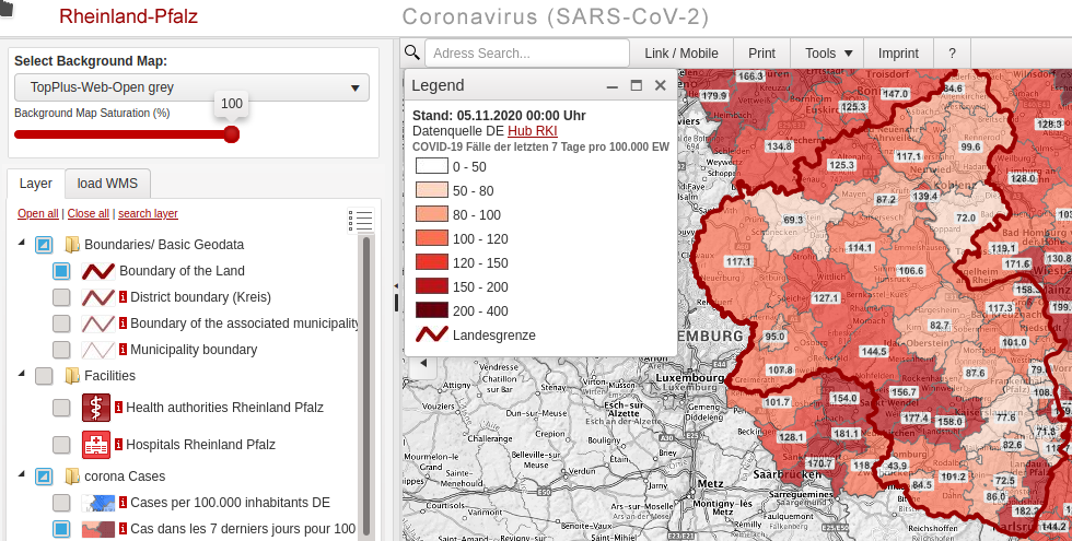
Daily updated corona incidences per county 1 | © netgis.de | map data © OpenStreetMap contributors | © RKI, DIVI Intensivregister, BKG, LVermGeo Rlp 2020
Mapping
- TheFive reported that weeklyOSM often receives messages alerting us to map errors. In a small blog post he points people
 > to the map notes system and encourages people to participate.
 - Yuu Hayashi, who published > a draft of a scheme for route mapping of Japanese historical paths, is asking how to manage a long-term mapping project with multiple members, and whether there is a form of monitoring that works better than updating mapping progress on OSM Wiki. He also asked if there is a better way to decide on a scheme for mapping a series of features than the Tag proposal process.
- The user Vollis proposed the tag
amenity=chapel_of_restfor a room or building where families and friends can say goodbye to a deceased person before his or her funeral. This proposal is now up for vote until 18 November. - Privatemajory, Luke proposed the tag
electricity=[grid, generator, yes, no]to indicate the electricity source used in a dwelling, a general building or a settlement. After a short voting period (29 and 30 October) the voting was stopped due to a formal error and the proposal is again in RFC state and open for comments.
 >
> 
 >
> Community
- The MapRoulette team pointed out, on Twitter, that a MapRoulette user box can be added to OpenStreetMap wiki user profile pages.
- The video ‘4 tools to start with OpenStreetMap‘, by Captain Mustache, is now available under a free Creative Commons BY licence on the PeerTube OpenStreetMap France instance.
- In another video, he answers the question, ‘OpenStreetMap? What is it?’
- In another video, he answers the question, ‘OpenStreetMap? What is it?’
- DeBigCs examined the claim that poorer areas around Dublin are less completely mapped than wealthier ones and the reasons for this.
- Jennings Anderson writes in his blog about ‘OSMUS Community Chronicles’, exploring the growth and temporal mapping patterns in North America.
- Nuno Caldeira is committed to the correct attribution of maps based on OSM and he has criticised Mapbox many times about the incorrect attribution function on their map service. This time, he praises Mapbox customer Flickr, which has managed to use correct attribution, even on the smallest maps. So, small size seems to be just an excuse and one can clearly add visible attribution on any map.
- OpenStreetMap US published its newsletter for November 2020.

OpenStreetMap Foundation
- You can find the key dates for the upcoming OSMF Annual General Meeting 2020 here.
- Mikel Maron would like to revitalise diversity and inclusion in the OSM Foundation; in his blog post he calls on all those who have been less represented so far not to be shy but to contact him.
Local chapter news
- FLOSSK, the Local chapter for OSM Kosovo, signed a Memorandum of Cooperation with the LUMBARDHI Foundation. This cooperation will serve for the exchange of knowledge, capacities, and resources for digitalisation, as well as the provision of materials and publications for free use by the public. FLOSSK and LUMBARDHI will cooperate in the digitisation of Zëri newspaper, TAN newspaper, and completion of the digital archive of Rilindja newspaper, as well as Jeta e Re, Përparimi and Çevren magazines, which will also be public with free access.
- Maggie Cawley, Martijn van Exel, and Steven Johnson report on the OpenStreetMap US Charter Project Program.
- The OpenStreetMap France Blog described > a cartographic portal initially developed by the OSM Cameroon Association. This interactive visualiser/downloader of OSM data (OSMdata ) allows you to visualise different OSM thematic layers, defined by Jean Louis Zimmermann and grouped into 16 geothematic layers. The open source code for the portal is on Github.
Events
- As part of National Heritage Week in Ireland, the local OSM community has decided to focus on the historic town of Clonmel. The first step was to quickly map from satellite imagery; in order to supplement this a Mapillary stream was also taken, COVID-19 compliant with mask from inside a car, using a camera attached to the window so that it could capture both sides of the road.
Humanitarian OSM
- Russell Deffner, from HOT, is asking for assistance in mapping Izmir, Turkey. On 30 October a magnitude 7.0 earthquake struck the region encompassing south/southeast Greece and western Turkey, with the epicentre being the city of Izmir, home to about 4 million residents.
Maps
- Sven Geggus has had trouble with the capacity tag on OpenCampingMap, wrote a blogpost about it, and is trying to engage with the community, on the tagging mailing list, to clarify ‘the meaning of the capacity tag for
tourism=camp_site‘. - AcquaMAT is a project powered by CleaNAP, based in Naples. It is creating a crowdsourced map of drinking water points scattered in all the cities of Europe, with the aim of promoting the use of public water, thus reducing the purchase of plastic bottles for water.
The map allows you to geolocate to see if there are points in the immediate vicinity of streets or squares of the city. Help the project by mapping water points that work and those that do not work, through a reporting form on the site. - [1] The map of Germany by sven_s8 , from the NETGIS > office in Trier, visualises the incidence of COVID-19, updated daily, as well as the intensive care bed situation (DIVI Intensive Care Register ) in districts or independent cities. It uses various open data interfaces and, of course, OpenStreetMap. The OSM data are imported via a map of the Federal Office of Cartography and Geodesy. The application uses the UMN Mapserver and PostgreSQL/PostGIS in the backend.
switch2OSM
- Deutsche Bahn has updated their information portal about active and future construction projects. The start page shows where all of the projects are located on an OSM-based map.
Software
- The JOSM issue tracker reached ticket #20000. The issue, a bug in the Wikipedia plugin, was fixed a few hours later.
- Mail.ru sold MAPS.ME to Daegu Limited for 1,557 million RUB (£15.3 million). They had acquired the mobile app and its services in 2014 for 542 million RUB (£5.3 million).
The app has been installed more than 140 million times and has ten million active users. - An updated version of mod_tile, the classic raster tile stack of OpenStreetMap, has been released by Felix Delattre, from the German Research Centre for Geosciences (GFZ). They packaged this software and included it as libapache2-mod-tile and renderd in Debian so that it will automatically be part of upcoming Debian and Ubuntu releases, and they are now asking for help with testing.
Releases
- Quincy Morgan reported the updates to iD in v2.19.4 (#2931).
- Tobias Zwick compared the download times for StreetComplete before and after he reworked the download to exclusively use the OSM API, instead of individual Overpass queries, in this chart. User mmd commented, on OSM Slack, that a similar reduction in download times might have been achieved through the performance improvements he developed for Overpass a year ago but which still haven’t been merged. The StreetComplete changes have been released in v26.0-beta1.
Did you know …
- … where to find the most complete statistics about the users of the different OSM editors?
- … Speichenkarte (spokes map), > which provides OSM data for Garmin devices?
- … the Dex2000 > Overpass query collection > ?
OSM in the media
- The Times of India reported that the OSM community in Kerala has created geospatial open data maps of all local government bodies in the state, numbering over 1200.
Other “geo” things
- The Open Geospatial Consortium (OGC) has adopted a new international standard, opening the way to a common format for cartographic description.
- If the world were a piano roll, this is what it would sound like.
- Marios Kyriakou created a YouTube video showing the entire changelog of QGIS 3.16 (Hannover). There is a lot to show in those 12 minutes, so it’s blazingly fast. If you prefer a slower overview you can also watch this screencast in Spanish made by Patricio Soriano from Asociación Geoinnova and QGIS.es. In this one the first 15 minutes are introduction and installation.
- In Quantarctica, a collection of Antarctic geographical datasets, version 4 is intended to offer expanded theme coverage and newer datasets, with more capabilities. Therefore, help is needed to identify the community’s requirements. The questionnaire takes a maximum of ten minutes to complete and will be very helpful in developing the next version of Quantarctica.
Upcoming Events
| Where | What | When | Country |
|---|---|---|---|
| Online | State of the Map Japan 2020 Online | 2020-11-07 |  |
| Taipei | OSM x Wikidata #22 | 2020-11-09 |  |
| Salt Lake City / Virtual | OpenStreetMap Utah Map Night | 2020-11-10 |  |
| Munich | Münchner Stammtisch | 2020-11-11 |  |
| Zurich | 123. OSM Meetup Zurich | 2020-11-11 |  |
| Berlin | 149. Berlin-Brandenburg Stammtisch (Online) | 2020-11-12 | |
| Online | 2020 Pista ng Mapa | 2020-11-13-2020-11-27 |  |
| Cologne Bonn Airport | 133. Bonner OSM-Stammtisch (Online) | 2020-11-17 | |
| Berlin | OSM-Verkehrswende #17 (Online) | 2020-11-17 | |
| Cologne | Köln Stammtisch ONLINE | 2020-11-18 | |
| Online | FOSS4G SotM Oceania 2020 | 2020-11-20 |  |
| Derby | Derby pub meetup | 2020-11-24 |  |
| Salt Lake City / Virtual | OpenStreetMap Utah Map Night | 2020-11-24 | |
| Düsseldorf | Düsseldorfer OSM-Stammtisch [2] | 2020-11-25 | |
| Taipei | OSM x Wikidata #23 | 2020-11-07 | |
Note: If you like to see your event here, please put it into the calendar. Only data which is there, will appear in weeklyOSM. Please check your event in our public calendar preview and correct it, where appropriate.
This weeklyOSM was produced by AnisKoutsi, Joker234, Lejun, MatthiasMatthias, MichaelFS, Nordpfeil, PierZen, Polyglot, Rogehm, TheSwavu, YoViajo, alesarrett, derFred, richter_fn.
Пойду, снова установлю MAPS.ME 🙂
The earthquake’s center was north/northwest of Samos island, not in Izmir. Izmir had the most destruction though.
Gratulacje w związku z polską wersją językową! 🙂 Congratulations on Polish language version! 🙂