23/03/2021-29/03/2021

National Cadastral Information System – Portugal [1] | © Direção-Geral do Território | map data © OpenStreetMap contributors
Mapping campaigns
- Code for Charlottesville is adding pavement (sidewalk), pedestrian crossing, and kerb data to OSM. This is for use in routing projects specifically aimed to make Charlottesville, Virginia more accessible for people with mobility issues by providing, for example, wheelchair routing. The project activities are described in their tutorial section, which is still under active review, so comments and feedback are welcome.
- As part of the fifth annual GeoNight (‘the Night of Geography’) numerous online Missing Maps mapathons have been organised for Thursday 8 April, Friday 9 April, and Saturday 10 April. The mapathons are co-organised with 15 organisations in 8 different countries: France, Germany, Mali, Senegal, Bangladesh, Nepal, Mongolia and Tajikistan.
- The German speaking Telegram group created a list of weekly mapping focuses with a wide range of themes.
- Disastermappers, CartONG, and OSMGhana are organising an online mapathon to be held on Saturday Tuesday 6 April at 4:30 pm GMT as part of the ‘International Weeks against Racism’ programme, sponsored by the Intercultural Center of the city of Heidelberg. You can register for the event here.
- Vlada Boitsik, from Mapbox’s RAVE Team, wrote a diary entry about the team’s organised editing activity regarding railway crossings in France carried out in March.
Mapping
- Nielkrokodil publishes
 > detailed instructions, in his user diary, on how he records and maintains the mapping of COVID-19 test stations in Austria.
 - The proposal for
place_of_worship=holy_well, an amenity used by Catholics to celebrate the well’s patron saint once a year, has received the necessary votes to get approved. - Rest of World featured an article about a mysterious OSM editor who changed OSM data to match China’s views, the vulnerability of open data projects such as Wikipedia and OSM to this type of manipulation, and described past efforts to ‘correct’ data.
 >
> 
Community
- Following a change to its affiliate policy, Amazon no longer shares part of its revenues with OSM in Germany > . To date the programme, which could be used by following a special link, had earned EUR 23,000 for OSM, but revenue had been declining recently.
- Jean-Christophe Becquet (APITUX > ) presented OpenStreetMap in ‘Dessinetaville: introduction to collaborative mapping‘ (video ), a conference organised by the Médiathèque de Chorges (Hautes-Alpes, France).
- Wikimedia Germany reports > a significant increase in edits to Wikipedia since the beginning of the pandemic. In particular, during the first phase the number of edits increased between 30 and 80 percent, while the trend started to slow down during the summer of 2020.
- Taro Matsuzawa (User smellman), an OSMFJ member, contributed > an article titled ‘OpenStreetMap Foundation Japan Example of building a tile server for the community’, in which he described in detail map tile systems and building a map tile server.
- The recent increase in spam messages in OSM has caused lengthy discussion > on the German forum during which some unrealistic expectations regarding the response time after which a spammer should be blocked had to be set straight.
 >
>  >
> OpenStreetMap Foundation
- Tobias Knerr, a member of the OSMF board, announced a proposal to change the OSMF’s Articles of Association in a way to allow long-term associate members to run for the board. At present you have to have been a member of the OSMF for at least 180 days, with associate membership not counting towards it.
- Clifford Snow, on behalf of the LCCWG Moderation Subcommittee, invited people to participate in the process of establishing a moderator team for the OSMF-talk and talk mailing lists and reviewing the existing etiquette guidelines (we reported earlier). To date the subcommittee has created a scope of work and finalised an implementation plan. You can express interest in participating in the process via this form. Expressions of interest close Saturday 10 April.
Maps
Open Data
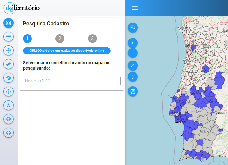
- The General Directorate of Territory, of the Government of Portugal, has made available an online viewer of the National Cadastral Information System that allows the consultation of land registry data and the structure of land ownership. The base map is OpenStreetMap.
- Project PLATEAU, run by the Japanese government, specifically by the Ministry of Land, Infrastructure, Transport and Tourism – MLIT, has released 3D city data for the 23 wards of Tokyo. The 3D models can also be viewed on the web. The data is available under ODbL. 3D data of 56 cities in Japan will be made available as open data.
 that allows the consultation of land registry data and the structure of land ownership. The base map is OpenStreetMap.
 on the web. The data is
 Software
- pocketnavigation.de reviewed > Topo GPS, a sophisticated outdoor navigation app, which combines official topographic maps with OpenStreetMap, as well as good orientation and planning functions with easy operation at low cost.
- User rainerU described > , how to filter OSM objects based on their tag history and the users involved using Osmium and Rory McCann’s osm-tag-csv-history.
Programming
- After updating his rendering stack to PostgreSQL 13.2 / POSTGIS 3.1.1 Stephan Knauss noticed a memory leak of about 2 GB per hour. Without any idea of the cause, many questions remain to be answered.
Did you know …
- … the Historic Place, an open map of the world? In 12 languages and with special maps!
OSM in the media
- The Israeli newspaper Haaretz featured a story about an Israeli military unit which posted a map on the National Emergency Portal with secret bases of the Israel Air Force and Military Intelligence including names and exact locations. According to the screenshot in the article the base map showing the secret bases is the OSM basemap.
Other “geo” things
- Grace Lapointe presented nine of the best fantasy maps found in books.
- While the Ever Given was aground in the Suez Canal, it was also visible to everyone in OSM 😉
- Ciaran Staunton tweeted a nice meme about the relationship between OSM contributors and consumers.
- Yama_Chizu has released the National Road Structures Map on the National Q Map. For example you can view the names and completion years of about 720,000 bridges in Japan.
- nagix has released Mini Tokyo 3D version 2.8.0. The current sky colour and the sun’s movement are now simulated. Also, aircraft tracking has been improved.
Upcoming Events
| Where | What | Online | When | Country |
|---|---|---|---|---|
| OpenStreetMap World Discord Spring Mapathon | 2021-04-03 – 2021-04-04 | |||
| 京都市 | 京都!街歩き!マッピングパーティ:第23回 Re:常寂光寺 | 2021-04-04 | jp | |
| Heidelberg | International Mapathon: Weeks Against Racism | ✓ | 2021-04-06 |  |
| London | Missing Maps London Mapathon | ✓ | 2021-04-06 | gb |
| Landau an der Isar | Virtuelles Niederbayern-Treffen | ✓ | 2021-04-06 | |
| Stuttgart | Stuttgarter Stammtisch (Online) | 2021-04-06 | | |
| Numérique Éducatif Libre Webinaire : Quels usages pédagogiques avec OpenStreetMap ? | 2021-04-07 | |||
| OSM Hour: Talking about the motivation of our industrial sponsors, shared to-do lists (online) | 2021-04-07 | |||
| Missing Maps Artsen Zonder Grenzen Mapathon | 2021-04-08 | |||
| Missing Maps Studentendesk Rode Kruis Maastricht | 2021-04-08 | |||
| Dresden | Dresdner OSM-Stammtisch | ✓ | 2021-04-08 | |
| Berlin | 154. Berlin-Brandenburg OpenStreetMap Stammtisch (Online) | 2021-04-09 | | |
| Charlottesville | Cville Sidewalks Mapathon | 2021-04-11 |  | |
| Hamburg | Hamburger Mappertreffen | 2021-04-13 | | |
| Using maps to help prevent and respond to Gender Based Violence | 2021-04-14 | |||
| Chippewa Township | OpenStreetMap Michigan Meetup | ✓ | 2021-04-15 | |
| Zürich | 3. Mapathon Rapperswil mit Missing Maps Zürich (virtuell) | ✓ | 2021-04-14 |  |
| Osborne County | OpenStreetMap U.S. Virtual Mappy Hour | ✓ | 2021-04-15 | |
| Liverpool | University of Liverpool Mapathon 2021! | 2021-04-15 | gb | |
| San Jose | Virtual Civic Hack & Map Night | ✓ | 2021-04-16 | |
| PoliMappers: Humanitarian Mapping with Map For Future | 2021-04-16 | |||
| 138. Treffen des OSM-Stammtisches Bonn | 2021-04-20 | |||
| City of Nottingham | OSM East Midlands/Nottingham meetup (online) | ✓ | 2021-04-20 | gb |
| Berlin | OSM-Verkehrswende #22 (Online) | 2021-04-20 | | |
| Lüneburg | Lüneburger Mappertreffen (online) | 2021-04-20 | | |
| Albuquerque | MapABQ April virtual meetup | 2021-04-22 | | |
| Weggis | Swiss OpenStreetMap Association Annual General Meeting | 2021-04-23 | |
Note:
If you like to see your event here, please put it into the OSM calendar. Only data which is there, will appear in weeklyOSM.
This weeklyOSM was produced by Elizabete, Climate_Ben, Lejun, Nordpfeil, Polyglot, SK53, SunCobalt, TheSwavu, YoViajo, derFred, muramototomoya.
The WeeklyOSM wrote:
> The Israeli newspaper Haaretz featured a story about an Israeli military unit which posted a map on the National Emergency Portal with secret bases of the Israel Air Force and Military Intelligence including names and exact locations. According to the screenshot in the article the base map showing the secret bases is the OSM basemap.
Please note that despite the newspaper’s claim that ” The Home Front Command of the Israel Defense Forces removed the classified information from the map after Haaretz asked about it.”, the Home Front Command did not modify the OSM map or data. Instead, the Covid-19 test centers are now shown using an ESRI base map.
Ref:
1. Original article with blurred base name – https://www.haaretz.com/israel-news/israel-army-secret-bases-online-map-1.9643700
2. Current OSM map of the same area – https://www.openstreetmap.org/#map=11/31.7618/34.9825
3. Home Front Command Covid-19 test centers – https://www.oref.org.il/12605-17147-he/Pakar.aspx
“Die israelische Zeitung Haaretz berichtet (en) > de über eine israelische Militäreinheit, die auf dem Nationalen Notfallportal eine Karte mit geheimen Stützpunkten der Luftwaffe und des militärischen Geheimdienstes inklusive Namen und genauen Standorten veröffentlicht hat. Laut dem Screenshot im Artikel ist die Karte, die die geheimen Stützpunkte zeigt, die OSM-Basiskarte.”
Laut dem Screenshot ist die Karte nicht die aktuelle OSM-Basiskarte (ist nicht osm carto), beruht aber wohl auf OSM Daten, evtl. ist es eine ältere Version des Mapnik-Stils. Laut Artikel kamen die “geheimen Daten” komplett von OSM und wurden nicht von der Militäreinheit die die Karte veröffentlicht hat, hinzugefügt: “In a statement, it added the map is from “a civilian website that provides global public services for making maps accessible around the world and in Israel. Marking the IDF camps and bases was not done by the military, but copied from the existing map on the website.”” Wahrscheinlich sind weitere Informationen zu diesen “geheimen” Stützpunkten der Wikipedia zu entnehmen…