11/05/2021-17/05/2021
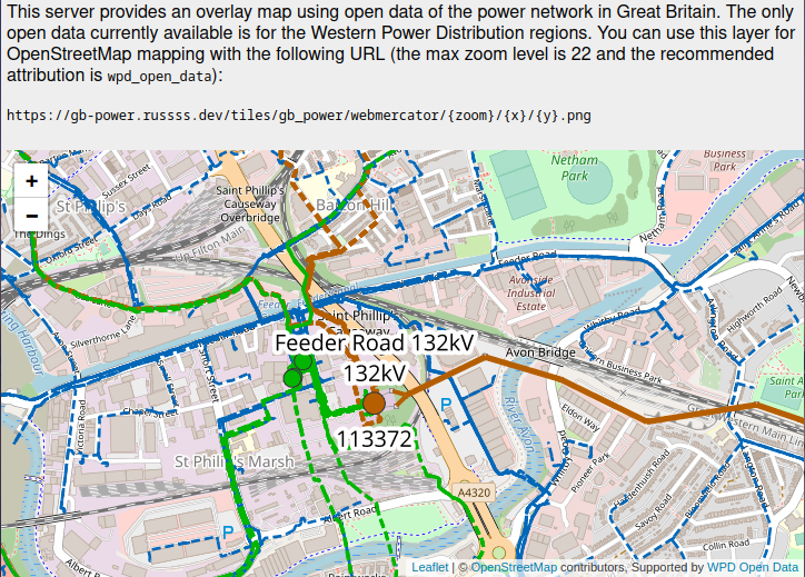
Russ Garrett’s raster layer of the electricity distribution network in southwest UK [1] | © Leaflet | © map data OpenStreetMap contributors, Supported by WPD Open Data
Mapping campaigns
- As part of a series of mapathons dedicated to flood-prone areas of Nigeria, over 7,500 buildings were added around Ikorodu in Lagos State, Nigeria. The mapathon was organised by a collaboration between the University of Bonn and the Geohazard Risks Mapping Initiative.
- MapUganda thanked the OSM community for contributions to the New Cities project. If you fancy also contributing the current target is Gulu city.
- As part of the monthly OSM Africa mapathon a task has been set up on the HOT Tasking Manager for mapping in Libya.
Mapping
- Brian Sperlongano provided an update on ideas to resolve inconsistencies in how OSM’s highway classification is used in the USA.
- 0235 showed how they were able to map their local amusement park in much greater detail.
- matheusgoemesms explained
 >
>
what he had to do in order to prepare a MapRoulette task based on external open data. - Requests have been made for comments on the following proposals:
man_made=stupato replaceman_made=towercombined withtower:type=stupa.-
stones=*a subkey for somenatural=*andlanduse=*tags to mark that the area is littered with stones of different types. giant_furniture=benchto tag ‘big’ benches.
- Voting for the proposed new tags about reusable packaging is open until Sunday 30 May.
 >
> 
Community
- YouthMappers has announced the setting up of YouthMappers Academy. The Academy is intended to strengthen YouthMappers students’ knowledge and proficiency to work with the ecosystem of OpenStreetMap software, tools and social and organisational skills related to creating open spatial data for humanitarian and development needs.
- Mariotomo wrote about how he set up a Telegram channel for Panama. In the comments Zverik suggests that with several moderators some of the rules may be unnecessary. Either way the discussion is likely to be of interest to organisers of national or local groups.
- Florian Lainez (user overflorian) suggested > , in a blog post, that OpenStreetMap is less of a community and more of a political movement.
 >
> Imports
- mbranco2 explains in his blog how to import a list of geo-referenced points of interest into OpenStreetMap with JOSM and Overpass Turbo.
OpenStreetMap Foundation
- The Board of OSMF is inviting feedback on their draft Strategic Plan outline.
Local chapter news
- User kocio announces > the launch of beta tile server for Poland, based on openstreetmap-carto style. For now, it covers the area of Poland at zoom levels up to z20 (compared to z19 on OSMF tile servers). Among other uses, it will serve as a test bed for cartographic ideas – he already implemented an improvement related to rendering of street parking.
 >
> Maps
- Richard Fairhurst, creator of cycle.travel, explained why it is difficult to find good cycle routes in London from OSM data
- drumber-1 has created a unique four swear word identifier for every 3 m by 3 m square in the UK and Ireland. Another similar project was launched in 2013 under the name ‘what3words’ and has led to many parody forks, as we reported.
- Raphaelmirc introduced >
Ciclomapa, a Brazilian map of cycle infrastructure based on OSM. This is a collaboration between the Brazilian Cyclists Union (UCB) and the national Institute of Transport and Development Policies (ITDP).
Open Data
- Hot on the heels of the French operator of the power distribution network starting a collaboration with OSM-FR through opening their data (as we reported), a major British distribution operator Western Power has released a trove of open data on their network. Western Power covers much of the Midlands of England and South Wales. Expect to see changes on OpenInfraMap in the near future. Russ Garrett has created a raster layer showing the data to facilitate this process.
- The OpenStreetMap France association (the French local chapter) has published an open letter > to defend the use of the ODbL license for open data in the transport sector in the face of the project to create a specifically French ‘Mobilities licence‘ > that is incompatible with the ODbL.
- Statistics Canada has released the new Open Database of Addresses, a collection of Canadian open address point data that is made available under the Open Government Licence – Canada. The current version of the database (version 1.0) contains approximately 10 million records and includes provinces and territories where open address data were found during the collection period (January to April, 2021). This release is part of the experimental Linkable Open Data Environment initiative.
Software
- IpswichMapper, the developer of SwiftAddress, needs to take time away from the project as they are experiencing mental health problems. The weeklyOSM team hopes these will resolve soon.
- Mail.ru (one of the leading internet companies in Russia) has launched a new minutely updated mirror of Planet OSM. Based on its location and channel bandwidth it could be a good choice for some Planet users.
- Auto Evolution suggested that a version of OsmAnd will be available soon for Android Auto.
Programming
- Daniel Capilla has added >
another example of Leaflet tutorials to his site Despliega tu mapa. This one shows how to add GeoJSON data to a map. The examples are aimed at non-programmers. - taginfo has had a facility since 2014 which allows specific individual projects to show which tags they consume. SomeoneElse shows how he generated suitable JSON for loading to taginfo from the Lua and Carto-CSS code behind his own maps for the UK and Ireland. The process was slightly simplified because all the tags used in Carto-CSS are also used in the Lua file, meaning that tags only needed to be extracted from one file.
 >
> Did you know …
- … you can add details about the local environment using StreetComplete? Jean-Louis Zimmerman shows how.
- … that Freizitekarte has detailed instructions >
for creating an up-to-date map of your own particular area for a Garmin device? - … NotesReview? Which allows easy browsing of OSM Notes across the globe.
- … that OSM now has more objects than there were people living on Earth in September 2019?
 >
> Other “geo” things
- The BBC explains why many satellite images of the Gaza Strip are both blurred and out-of-date.
- The radio station Deutschlandfunk Kultur broadcast > , on its Lange Nacht, a programme about cartography.
- Viabundus is a routable transport map for Northern Europe around 1500. The map and associated data are the work of the Institut für Historische Landesforschung (IHLF) at Georg-August-Universität Göttingen. A modern OSM map is used as an orientation background map.
- 2021 is the year of Brood X of periodical cicadas with a 17-year cycle. As well as millions of the insects, over 87,000 citizen scientists have been recruited to map the emergence of the bugs.
Upcoming Events
| Where | What | Online | When | Country |
|---|---|---|---|---|
| Schaerbeek – Schaarbeek | Balade: Cartographions la surveillance à Schaerbeek! | 2021-05-23 |  | |
| London | London virtual OSM social | 2021-05-23 – 2021-05-24 |  | |
| Bremen | Bremer Mappertreffen (Online) | 2021-05-24 |  | |
| Derby | East Midlands OSM Pub Meet-up : Derby | 2021-05-25 | | |
| Gárdony | OSM Fonó: Mapping Kápolnásnyék together on a shared split-screen (online) | 2021-05-25 |  | |
| Ville de Bruxelles – Stad Brussel | Virtual OpenStreetMap Belgium meeting | ✓ | 2021-05-25 | |
| Düsseldorf | Düsseldorfer OSM-Treffen (online) | 2021-05-26 | | |
| okres Žilina | Missing Maps mapathon Slovakia online #3 | 2021-05-27 |  | |
| #ValidationMay: The Importance of Data Quality in Humanitarian Mapping | ✓ | 2021-05-28 – 2021-05-29 | ||
| [Online] OpenStreetMap Foundation board of Directors – public meeting | 2021-05-28 | |||
| gmina Krośniewice | Virtual meeting of the Polish OSM Association | 2021-05-28 |  | |
| London | Missing Maps London Mapathon | 2021-06-01 | | |
| Landau an der Isar | Virtuelles Niederbayern-Treffen | ✓ | 2021-06-01 | |
| Stuttgart | Stuttgarter Stammtisch (Online) | 2021-06-01 | | |
| Dresden | Dresdner OSM-Stammtisch | ✓ | 2021-06-03 | |
| Berlin | 156. Berlin-Brandenburg OpenStreetMap Stammtisch (Online) | 2021-06-04 | | |
| OSM Africa Monthly Mapathon: Map Libya | 2021-06-05 | |||
| Rapperswil-Jona | FOSSGIS-Konferenz 2021 (Online) | ✓ | 2021-06-06 – 2021-06-09 |  |
| Rapperswil-Jona | OSM-Sonntag (FOSSGIS-Konferenz 2021) | 2021-06-06 | | |
| OpenStreetMap x Wikidata Taipei #29 | 2021-06-07 |  | ||
| Missing Maps Artsen Zonder Grenzen Mapathon | 2021-06-10 |
Note:
If you like to see your event here, please put it into the OSM calendar. Only data which is there, will appear in weeklyOSM.
This weeklyOSM was produced by MatthiasMatthias, Nordpfeil, RicoElectrico, SK53, Sammyhawkrad, TheSwavu, YoViajo, derFred.