18/05/2021-24/05/2021
Open Healthcare Access Map [1] | © Leaflet | © OpenStreetMap contributors, openrouteservice, WorldPop, geoboundaries
Mapping campaigns
- HOT has published an article on the role of validators in both improving data quality and giving feedback to new mappers. It also advises jow to become a validator.
Mapping
- In a diary entry, Fiftyfour tells us about his experience with OpenStreetMap and suggests how the main website could be improved for interested users.
- Harry Wood reflected on his recent armchair-mapping session, focused on the Northwick Park Hospital complex in North West London. The post includes considerations about armchair mapping, finding deleted OSM data and future OSM (virtual) events.
- After almost a year of debate within the Portuguese OpenStreetMap community, a proposal for the standardisation
 > of localities and administrative boundaries has entered the voting phase. For more information, see the project wiki page or the official group channel on Telegram.
 - Voting has ended for the following proposals:
post_office=*(shop as post-partner) was approved with 23 votes for, 1 against and 3 abstentions. The proposal is documented in the new tag post_office=* and on amenity=post_office. In this context, the keypost_office:type=was marked as deprecated.landuse=educationwas approved with 56 votes for, 12 votes against and 5 abstentions.
- Milos Popovic tweeted about his new map, showing railway density in India at a sub-district level. In a related blog post, Milos unveils the R code and OSM data behind this map.
- Nathan Case has summarised tag usage for residential property in the UK.
 >
> 
OpenStreetMap Foundation
- The minutes of the last OSM Board meeting are now available online. Amongst the topics discussed were: a possible move of the Foundation, as a legal entity, out of the UK; the restart of the Engineering Working Group; the banking situation; iD development; and hiring a site reliability engineer.
- As SotM 2021 will be held virtually, the organisers want to try something new: alongside the recorded talks in English, they wish to offer live translation in as many languages as possible. Wish to participate? Check out this blog post for more details, and contact the organising committee before Monday 28 June.
- Jean-Marc Liotier explained the background of the trademark agreement between OSM Foundation and GeOsm, a Cameroonian portal that distributes geographic data for 21 African countries. The agreement was signed in Yaoundé, in a formal ceremony that included government representatives.
Local chapter news
- Jennings Anderson published the slides from his State of the States 2020 – Mapping USA Talk, with very interesting graphics and statistics.
Events
- The 2021 edition of the State of the Map France cannot take place in person, so the OpenStreetMap France association is offering > an online Mini-SotM-FR 2021 for one week, from Monday, June 7 to Friday, June 11, with one event at 12:30 pm and another at 9 pm (CEST). You will be able to attend presentations, feedback, workshops and participate in a mapathon with CartONG. The sessions will be live video conferences open to all, free and with optional registration.
 >
> Education
- OpenMap Development Tanzania announced the start of Open Skies Fellows: Africa Tech for African Data, implemented in partnership with HOT and Uhurulabs and supported by Fondation Botnar.
Maps
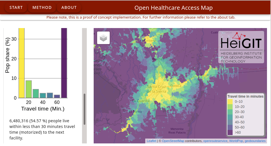
- Marcel Reinmuth noted that following on after Sub-Saharan Africa and South and Southeast Asia, HeiGIT has now published all countries of Central and South America on the Open Healthcare Access Map.
- dcapillae has created > an interactive map with the locations of the new plaques of the ‘Málaga makes history’ initiative of Málaga City Council.
- Mohammed Rizwan Khan described how ohsomeHex can show how your city was mapped over time, how geometries were changed and refined, and how mistakes were added and corrected again. ohsomeHex has a great new feature — the individual object’s zoom-in-history-view.
- The Cooper Hewitt, Smithsonian Design Museum has acquired the Watercolor Maptiles for its digital design collection. Launched by Stamen Design in 2012, the web-based map displays OpenStreetMap’s data with the hand-hewn textures of watercolour paint.
 >
> Open Data
- The local government of Vevey, Vaud, Switzerland, has added street-level imagery to Cartoriviera > , the open data portal shared by several communes on the shores of Lake Geneva.
Licences
- Johannes Filter reported that a Bavarian government agency has posted a DMCA takedown notice to GitHub, to delete government geodata of German homes. Let’s see if they manage to prevent the data from spreading. Several forks are also affected, including a repo of his.
 that a Bavarian government agency
 Software
- GpxPod is a Nextcloud application to view, analyse, compare, and share GPS tracks.
- The Graphhopper routing engine has been updated to version 3.0. The new version allows the visualisation of route details, a tool to place a GPX track on routes already on the map has been added, and the performance of isochronous maps and general performance have been improved.
- Johannes Kröger has created Leafroulette, an animated map of Hamburg that switches between numerous map layers or, as he describes it, ‘a screensaver, CPU burner, background animation thing’.
Programming
- The OpenStreetMap Ops Team is now publishing a RSS feed for weekly planet file torrents.
Releases
- Tobias Zwick has released StreetComplete v32, a mega-update that features, amongst other things, undoing edits in any order, built-in support for reverting deletions and a greatly improved offline mode.
Other “geo” things
- The success of the map of Valencia with the buildings coloured according to their period of construction based on the Spanish cadastre has led Dominic Royé to offer Valencia, Barcelona, Madrid, Sevilla, Santiago de Compostela and Malaga in PDF format.
- In honour of Global Accessibility Awareness Day, Google has shared a list of tips on how to add accessibility information to Google Maps, either as metadata in a review, as attributes of a business, or as public lists of accessible locations.
- Guillaume Métayer created a combination of the ancient Cassini map from 1756 covering the area South-East of Paris with layers of modern infrastructure and objects of historical interest with additional information in pop-ups (French only).
- Sir_Lazz, a 20 year old French game art student, has created a map of Galicia (Spain) and Japan in the style of Super Mario World.
- Liberty Sheldon, from Cycling Industry News, reports that new research carried out for #BikeIsBest, using OpenStreetMap data, has found “at least” 25,000 modal filters in the UK. A modal filter restricts motor vehicle access but usually enables access for walking and cycling; they are commonly used as part of low traffic neighbourhoods.
Upcoming Events
| Where | What | Online | When | Country |
|---|---|---|---|---|
| #ValidationMay: The Importance of Data Quality in Humanitarian Mapping | ✓ | 2021-05-28 – 2021-05-29 | ||
| Bogotá Distrito Capital | Resolver notas de Bogotá creadas en OpenStreetMap | 2021-05-29 |  | |
| London | Missing Maps London Mapathon | 2021-06-01 |  | |
| Landau an der Isar | Virtuelles Niederbayern-Treffen | ✓ | 2021-06-01 |  |
| Stuttgart | Stuttgarter Stammtisch (Online) | 2021-06-01 | | |
| Dresden | Dresdner OSM-Stammtisch | ✓ | 2021-06-03 | |
| Bogotá Distrito Capital | Resolver notas de Bogotá creadas en OpenStreetMap | 2021-06-05 | | |
| OSM Africa Monthly Mapathon: Map Libya | 2021-06-05 | |||
| Rapperswil-Jona | FOSSGIS-Konferenz 2021 (Online) | ✓ | 2021-06-06 – 2021-06-09 |  |
| Rapperswil-Jona | OSM-Sonntag (FOSSGIS-Konferenz 2021) | 2021-06-06 | | |
| Mini-SotM-FR 2021 en ligne | 2021-06-07 – 2021-06-11 | |||
| Taipei | OpenStreetMap x Wikidata Taipei #29 | ✓ | 2021-06-07 |  |
| Torino | PoliTO Mapping Party for Students | 2021-06-08 |  | |
| Missing Maps Artsen Zonder Grenzen Mapathon | 2021-06-10 | |||
| Berlin | 156. Berlin-Brandenburg OpenStreetMap Stammtisch (Online) | 2021-06-11 | | |
| 140. Treffen des OSM-Stammtisches Bonn | 2021-06-15 | |||
| Berlin | OSM-Verkehrswende #24 (Online) | 2021-06-15 | | |
| Lüneburg | Lüneburger Mappertreffen (online) | 2021-06-15 | | |
| Missing Maps German Red Cross Digitaltag Mapathon | 2021-06-18 |
Note:
If you like to see your event here, please put it into the OSM calendar. Only data which is there, will appear in weeklyOSM.
This weeklyOSM was produced by Anne Ghisla, Climate_Ben, Lejun, MatthiasMatthias, Nordpfeil, SK53, TheSwavu, derFred, tordans.