25/07/2023-31/07/2023
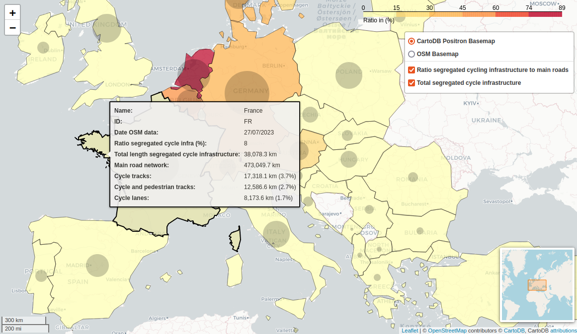
Verhältnis von getrennter Radverkehrsinfrastruktur zum Hauptstraßennetz [1] © ECF, OpenStreetMap-Mitwirkende
Mapeamento
- b-unicycling adicionou etiquetas
name:etymology:wikidataaos poços sagrados na Irlanda e analisou a ocorrência de diferentes santos nos nomes. - A HDYC está agora equipada com uma funcionalidade para detetar as nossas edições do OpenStreetMap que foram apagadas por outros. Verifica o teu perfil HDYC e depois clica no menu "alterações revertidas".
- une abeille explica passo a passo e em pormenor por que razão e como estão a cartografar os passeios.
Foram feitos pedidos de comentários sobre as seguintes propostas:
noname=*para alargar a etiquetanoname=yesexistente, acrescentando valores adicionais para indicar a razão pela qual uma etiquetanamenão está presentehistoric=defensive_workspara fazer da chavedefensive_worksuma sub-tag, permitindo aos mapeadores usar uma tag genérica para obras defensivas, que pode mais tarde ser especificada comdefensive_works=*por mapeadores com mais conhecimento local e/ou compreensão do tópico.
Comunidade
- Hungerburg apercebe-se de que os glaciares rochosos não estão muito bem cartografados na sua região e descobre que existe um conjunto de dados abertos que analisa para importar para o OSM.
- O 19º aniversário do OpenStreetMap será celebrado a 9 de agosto de 2023. As comunidades OSM que queiram celebrar a ocasião organizando atividades locais podem inscrever-se na página wiki "Festa de aniversário do 19º aniversário do OpenStreetMap".
Notícias de capítulos locais
- O OpenStreetMap US anunciou que Locana se juntou à organização como membro apoiante.
- Os vídeos do State of the Map US 2023 começaram a ser carregados no YouTube.
Eventos
- O prazo para o convite à apresentação de resumos para o OSMScience 2023 (que se realiza no âmbito do State of the Map Europe 2023) foi prorrogado até 24 de agosto de 2023.
- O Geomob (https://mapstodon.space/@geomob/110774937291421110) informou que não estão previstos eventos para agosto, mas que há muitos na agenda a partir de setembro.
- A equipa do State of the Map Europe abriu o seu convite à participação. Chegou o momento de apresentar a sua ideia para uma apresentação, um workshop ou painéis de opinião. O prazo termina a 24 de agosto.
Educação
- Vídeo de Rainbolt sobre geolocalização que faz uso do overpass turbo.
Investigação OSM
- A Federação Europeia de Ciclistas apresentou uma análise da quantidade de infra-estruturas segregadas para ciclistas existentes em 20 países europeus diferentes, expressa em proporção do comprimento da rede rodoviária principal de cada país.
Mapas
- SomeoneElse criou um estilo de mapa Garmin e explica os pormenores no seu blogue. As etiquetas utilizadas são documentadas com taginfo.
Dados abertos
- A Overture Maps lançou o conjunto de dados Overture 2023-07-26-alpha.0. Este conjunto de dados contém várias camadas, nomeadamente lugares de interesse (POIs), edifícios, redes de transportes e regiões administrativas.
- A Umbra libertou mais de $1 milhão de dados SAR gratuitos, desde 15 de março de 2023.
Software
- Dê uma vista de olhos à versão de demonstração do pré-projeto de uma ferramenta de avaliação da qualidade (
 & ) dos dados OSM, fornecida pelo Instituto de Heidelberg para a Tecnologia da Geoinformação.
 - Rohit Gautam lançou o OSM-GPT, um chatbot para interagir diretamente com os dados do OpenStreetMap.
- OsmAnd 4.5 foi lançado para Android. Inclui uma função de cópia de segurança gratuita, novos formatos de terreno e de relevo 3D e capacidades para ligar sensores Bluetooth.
- O StreetComplete pede tradutores nas notas de lançamento da v53.3. Os falantes nativos de "Turco, Malayalam, Amárico, Arménio, Bósnio, Norueguês Nyorsk, Galego e Japonês" podem ajudar a traduzir a aplicação em poedit.com. As línguas cuja tradução se torna de baixa qualidade devido à falta de manutenção são removidas da aplicação, até que a qualidade da tradução seja restaurada.
- O fornecedor de quadrículas Tracestrack abriu o seu mapa online genérico Tracesmap no Github. O mapa integra muitos serviços baseados no OpenStreetMap, tais como Tracestrack raster tiles, OpenRouteService, Overpass API, Nominatim search, OpenRailwayMap, bem como alguns produtos comerciais como Mapbox Satellite Imagery e TomTom Traffic.
 &
&  ) dos dados OSM, fornecida pelo Instituto de Heidelberg para a Tecnologia da Geoinformação.
Programação
- Interessado em ampliar o seu horizonte sobre "Generalização da extração de códigos de exemplo, dados tabulares e Infoboxes de MediaWikis como OSM.wiki"? Então dê uma olhadela ao diário de fititnt.
- bdon desenvolveu a aplicação overture-tiles, um mapa Web para apresentar dados de pontos de interesse que foi recentemente lançado pela Overture Maps.
OSM nos média
- Kiran Herbert da People for Bikes relata que a cidade de Minneapolis tem o índice de conforto para ciclistas mais elevado dos Estados Unidos. Esta pontuação é medida com base nos dados das ciclovias disponíveis no OpenStreetMap.
Outras coisas “geo”
- Manon Bischoff escreveu ► um artigo no Spektrum der Wissenschaft sobre a história da procura de uma prova da conjetura das quatro cores (a ideia de que se pode colorir qualquer mapa usando no máximo quatro cores diferentes).

Próximos eventos
| Onde | O quê? | Online | Data | País |
|---|---|---|---|---|
| Sankt Augustin | FrOSCon 2023 – St. Augustin / Germany | 2023-08-05 – 2023-08-06 |  | |
| OSMF Engineering Working Group meeting | 2023-08-09 | |||
| Budapest | #OSM19 birthday fish and ice cream on the beach | 2023-08-09 |  | |
| München | Münchner OSM-Treffen | 2023-08-09 | | |
| Montrouge | Rencontre contributeurs Sud de Paris | 2023-08-10 |  | |
| Budapest | #OSM19 birthday QGIS editing, drinks, party games | 2023-08-11 | | |
| Zürich | OSM-Stammtisch | 2023-08-11 |  | |
| Recording milk churn stands for Ireland’s National Heritage Week 2023 | 2023-08-12 – 2023-08-20 | |||
| Localidad Teusaquillo | Volvamos a cerrar notas de OSM en Colombia – Notathon | 2023-08-12 |  | |
| Queens | Mapping Access on Austin Street | 2023-08-12 |  | |
| København | OSMmapperCPH | 2023-08-13 |  | |
| 166. Treffen des OSM-Stammtisches Bonn | 2023-08-15 | |||
| San Jose | South Bay Map Night | ✓ | 2023-08-16 | |
| Lüneburg | Lüneburger Mappertreffen (online) | 2023-08-15 | | |
| The Municipal District of Castlecomer | Recording milk churn stands for Ireland’s National Heritage Week 2023 (workshop) | 2023-08-16 |  | |
| Köln | Stammtisch Köln | 2023-08-16 | | |
| Singapore | OpenStreetMap and Wikimedia: Awesome Together! | 2023-08-17 | sg | |
| Singapore | Giving Contexts to Places We Love – The Power of OpenStreetMap and Wikidata | 2023-08-17 | sg | |
| The Municipal District of Kilkenny City | Heritage Week Heritage Mapping Clinic | 2023-08-17 | | |
| Hannover | Maker Faire Hannover 2023 | 2023-08-19 – 2023-08-20 | |
Nota: Se pretender ver o seu evento aqui, por favor OSM Kalender coloque-o no calendário. Só dados lá colocados aparecerão no weeklyOSM.
Este semanárioOSM foi produzido por Elizabete, MatthiasMatthias, NunoMASAzevedo, TheSwavu, derFred, rtnf.