08/08/2024-14/08/2024
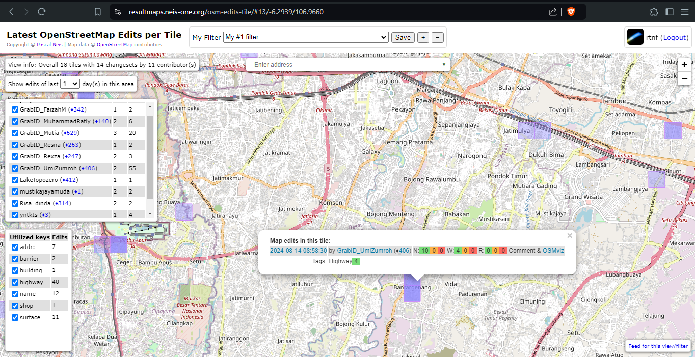
Últimas Edições do OpenStreetMap por Tile [1] | © Pascal Neis | Dados do mapa © Contribuidores do OpenStreetMap
Mapeamento
- Na Áustria, agora é permitido que ciclistas continuem pedalando após uma curta parada, apesar do semáforo vermelho. Há uma nova placa de trânsito para isso. Thomas Neubauer já mapeou quatro das placas relevantes para ciclistas em Graz e está solicitando ajuda.
- Uma solicitação de comentários foi feita para a proposta
service=bus bay > . A etiqueta serve para indicar que uma via é usada exclusivamente para acessar plataformas de ônibus.
 >
> 
Comunidade
- Nosso membro da equipe editorial rtnf compila > alguns parabéns pelo 20º aniversário do OSM em seu blog. Infelizmente, nossa pequena equipe certamente não conseguiu coletar todas as felicitações, mas a equipe do semanárioOSM deseja tudo de melhor, pelos próximos 20 anos e mais.
- Elliott Plack escreve em seu diário > sobre os diferentes tipos de notas no OpenStreetMap e como aquelas, que exigem conhecimento local, podem ter menos valor, já que a maioria das notas OSM são resolvidas no conforto do seu lar.
- Marcus nos envia um agradecimento. Ele levou a família para um parque de diversões em Ohio, no Dia da Independência dos EUA, e usou o app Organic Maps para chegar lá, encontrar um hotel e um lugar para comer, sem nenhum problema.
- Martin Hoffmann informa que o seu projeto, Railway History Map, foi apresentado num artigo da Heise, comemorando os 20 anos do OpenStreetMap
- O OpenStreetMap Vietnã faz um pedido para que as pessoas sigam sua conta no Mastodon e impulsionem as suas postagens, prometendo muito conteúdo interessante para acompanhar.
- Steve Coast reflete > sobre a jornada de 20 anos do OpenStreetMap, destacando seu crescimento, de uma ideia ousada para um projeto global, conduzido por voluntários, que mapeou o mundo de graça. Ele relata suas dúvidas iniciais sobre a viabilidade do projeto, que desapareceram, depois de ver mapas detalhados de Cuba. Steve destaca o papel das pessoas, ideias e tecnologia para o sucesso do projeto OSM e incentiva a comunidade a continuar a inovar e a criar novos projetos, que podem mudar o mundo.
- Richard Fairhurst relembrou > os primeiros dias do OpenStreetMap, apontando que não seria possível construir o OSM em 2024, visto que, provavelmente, seria esmagado pelo Google, ou fracassaria, devido às expectativas dos usuários do Reddit/HackerNews: “por que ainda não está bom?” Ou fracassaria, em alguma controvérsia sobre a privacidade ou as fronteiras disputadas.
- [1] O OpenStreetMap Utah explica > como usar o aplicativo Latest OpenStreetMap Edits per Tile (Últimas Edições do OpenStreetMap por Tile), de Pascal Neis > , que permite aos usuários, visualizar as edições recentes do OpenStreetMap em tiles específicas, incluindo ricos detalhes, como os tipos de edições e seus autores, e como filtrar e marcar como favoritas, visualizações específicas do mapa. O aplicativo também oferece suporte a assinaturas RSS, para atualizações sobre novas edições em uma visualização de mapa selecionada.
Fundação OpenStreetMap
- Há um novo rascunho > da proposta OSM Editor Inclusion Policy (Política de Inclusão de Editores do OSM). As diretrizes definirão os critérios que os novos editores terão que atender, a fim de serem apresentados na página do OSM.
Eventos
- O grupo OSM Fukushima organizou > uma festa de mapeamento na cidade de Aizu Wakamatsu (Fukushima, Japão). Para comemorar o aniversário de 20 anos do OpenStreetMap, dez pessoas se reuniram e mapearam o símbolo da cidade, o castelo Wakamatsu (ou Tsuruga-jo).
- Ainda pode apresentar o seu projeto ou visualização cartográfica no State of the Map 2024 > . A chamada para pôsteres > está aberta até 25 de agosto de 2024. Já o prazo para registro de Lightning talks > terminará em 20 de agosto.
OSM Humanitário
- The New Indian Express noticia > sobre o mapeamento no OpenStreetMap no estado de Querala (Índia), em resposta aos deslizamentos > de terra de Wayanad, em 2024. Isso ocorreu após o mapeamento da bacia do rio Kabini, com foco especial em regiões afetadas por inundações e propensas a deslizamentos de terra, um projeto iniciado em 2023 e concluído em 2024.
Mapas
- O Quick Map (mapa rápido) do dia, de Jeff Allen, é o mapa de isócronas de trânsito, do centro de Eau Claire (Wisconsin, EUA).
- A OSM está mais uma vez fornecendo o mapa base para o Programa Noite da Cultura ► de Patti, na Itália.
- Trailcatalog.org é um site sobre trilhas do OpenStreetMap, permitindo > que os usuários pesquisem trilhas globalmente e visualizem suas distâncias e elevações. O site também facilita as correções, com links para o OSM.
- Sakanoshita desenvolveu um site chamado Let’s look at some old maps (Vamos ver alguns mapas antigos), onde os usuários podem comparar e visualizar mapas OSM, de dois em dois anos. Em um artigo que apresenta o serviço, ele diz que as pessoas podem ver como a região mudou e como os dados OSM são enriquecidos. >
 o
o  >
> OSM em ação
- O mapa What will climate feel like in 60 years? ajuda a responder à pergunta “como será o clima da minha cidade daqui a 60 anos?”. Ao selecionar a sua cidade de interesse, o mapa baseado no OSM mostrará qual localização atual tem o clima mais semelhante ao previsto para 2080.
- Tobias Tordans percebeu que o Mapillary/Facebook não usa mais os edifícios do OpenStreetMap em seu mapa baseado em OSM, mas mudou para o conjunto de dados de edifícios do Overture. Esse conjunto geralmente prioriza > dados do OSM em relação aos dados de IA, mas adiciona edifícios de IA, onde eles estão ausentes no OSM.
- TrailStash publica que ficaram tão lisonjeados,que o Overpass Ultra foi comparado ao Map Equals Yes da Stamen, que se sentiram compelidos a recriá-lo.
Dados abertos
- A HOT está buscando > melhorar a usabilidade humanitária de dados espaciais abertos por meio do OpenStreetMap, em suas áreas de atuação, aderindo à rede H2H Network e ao seu programa > Enabling H2H Approaches for Anticipatory Action (Habilitando as abordagens H2H para ação antecipatória).
Software
- O usuário do OpenStreetMap, barefootstache, descobriu que é possível ter vários botões rápidos personalizados, a partir da versão 4.8 do OsmAnd. Ele criou > um conjunto de botões rápidos (tablets) e instruções sobre como criar os seus próprios tablets.
- Um novo documento de governança para o projeto iD Tagging Schema (Esquema de Etiquetagem do iD) estabelece > dois co-mantenedores, descrevendo as suas responsabilidades, os processos de tomada de decisão e as suas funções, garantindo um gerenciamento transparente e organizado do projeto. O documento de diretrizes fornece > instruções sobre como os contribuidores devem adicionar etiquetas e elementos ao projeto, enfatizando consistência, clareza e envolvimento da comunidade nas contribuições.
- A fltb apresentou > uma atualização do seu projeto de editor relacional de transportes públicos do OpenStreetMap. O desenvolvimento principal está quase concluído, com o objetivo de refinar as funcionalidades. Uma máquina robusta gerencia agora as ações de edição, fornecendo uma base para a funcionalidade de desfazer/refazer (Undo/Redo). O motor de renderização está funcional, mas requer melhorias estéticas. As próximas tarefas incluem a criação de uma interface de fácil utilização e a implementação de funcionalidades essenciais de edição de transportes públicos.
Atualizações
- O OSHDB é um framework de alto desempenho para análise espaço-temporal de registros históricos completos do OpenStreetMap, desenvolvido pelo HeiGIT, como parte do projeto ohsome. A versão 1.2.3 foi lançada em 28 de junho de 2024 e o tutorial First Steps using the OSHDB-API (Primeiros passos usando a API OSHDB) está disponível na página do projeto > no GitHub.
- Martijn van Exel tem o orgulho de anunciar uma nova versão do wrapper Python da API Overpass, após um intervalo de cinco anos.
- O Vespucci 20.1 foi lançado no Google Play.
Você sabia que…
- … você pode viajar de volta no tempo, até 2007, e ouvir a palestra de Steve Coast This Mapping Stuff Could Really Take Off (Esse Negócio de Mapeamento pode Realmente Decolar), ministrada no primeiro State of the Map? Os slides da palestra também estão disponíveis.
- … você pode usar o OpenAerialMap como camada de fundo no EveryDoor (editor do OpenStreetMap)? Isso é possível graças ao serviço de mosaico OAM, fornecido pela KonturIO.
- … há uma página Wiki OSM > completa sobre o assunto “notas”? Há também orientações sobre como utilizá-las.
- … existe o aplicativo Web chamado OSM Open? Hauke Stieler o desenvolveu para encontrar pontos de interesse (POIs) abertos. Você pode filtrar os dados por qualquer etiqueta e o código-fonte está disponível no GitHub.
- … há a possibilidade de usar o bbbike com World Full History (Histórico Completo do Planeta) para pesquisar POIs deletados? Tordans o descobriu, quando estava procurando por um POI deletado (uma cervejaria após a reabertura ;-), a fim de restaurá-lo.
- … você pode fazer um quebra-cabeças de mapas baseados no OSM?
OSM na mídia
- Por ocasião dos “20 anos de OSM”, Les Numeriques apresenta > um relatório pormenorizado sobre o concorrente Google.
- O OpenStreetMap foi fundado em agosto de 2004, o Google Maps, em fevereiro de 2005, seis meses depois. No entanto, a maior parte da cobertura midiática fala da fundação do OSM para “enfrentar o Google Maps”, um feito só possível com acesso a uma máquina do tempo. Como SK53 e Simon Poole referem, o alvo original era o Ordnance Survey do Reino Unido.
- A revista italiana Wired dedicou um artigo > aos 20 anos do OpenStreetMap.
- Kim Rixecker publica na t3n, o artigo > intitulado “O que precisa saber sobre a alternativa gratuita ao Google Maps” (traduzido).
 >
>  >
> Outros assuntos “geo”
- HeiGIT, ou Instituto de Tecnologia da Geoinformação de Heidelberg, procura > um cientista sênior de dados espaciais para a ação climática. A pessoa selecionada trabalhará na geração de indicadores espaciais de preparação para as mudanças climáticas e de estimativas das emissões de gases de efeito de estufa, com uma resolução espacial muito elevada.
- O Joint Research Centre of the European Commission (Centro Comum de Investigação da Comissão Europeia) está abrindo uma vaga de emprego para a posição de especialista em SIG.
- A trilha #geoweirdness desta semana foi dedicada às curiosidades geográficas da Suíça
- A Pastmaps oferece uma extensa coleção, com mais de 185 mil mapas históricos dos Estados Unidos, permitindo aos usuários, explorar e analisar dados históricos, utilizando ferramentas profissionais. A plataforma oferece mapas georreferenciados e de alta resolução, que podem ser pesquisados por cidade, estado ou condado, além de outras funcionalidades, como a visualização 3D e o download de mapas.
- Vegard J. Løwe desenvolveu o World in Dots (Mundo em pontos), uma ferramenta on-line, que permite aos usuários criar mapas de pontos vetoriais com opções personalizáveis, como a densidade, o tamanho, a cor e a forma dos pontos. Os usuários podem criar mapas, selecionando regiões ou países, ajustando o tamanho da tela e realizando o download do mapa final, em formato SVG ou PNG.
Próximos eventos
| Town | Title | Online | Date | Country |
|---|---|---|---|---|
| Lorain County | OpenStreetMap Midwest Meetup | ✓ | 2024-08-15 |  |
| Tanah Sareal | Scout Community OSM Training in Jamboree event, Bogor City | 2024-08-15 |  | |
| Umuarama | [on-line] 🎁 20 anos de OSM #1 – Oficina do IVIDES.org para a UNIPAR (Brasil) | 2024-08-16 |  | |
| OSMF Engineering Working Group meeting | 2024-08-16 | |||
| Sankt Augustin | OSM auf der FrOSCon Sankt Augustin | 2024-08-17 – 2024-08-18 |  | |
| Hannover | OSM auf der Maker Faire Hannover | 2024-08-17 – 2024-08-18 | | |
| Варна | OpenStreetMap in Varna (на морето) | 2024-08-17 |  | |
| Hannover | OSM-Stammtisch Hannover | 2024-08-17 | | |
| Meerut | 1st OSM Meerut Mapping Party | 2024-08-18 |  | |
| Sankt Augustin | Vortrag: 20 Jahre OpenStreetMap | 2024-08-18 | | |
| The Municipal District of Kilkenny City | Citizens Science and Linked Open Data | 2024-08-19 |  | |
| The Municipal District of Kilkenny City | Citizen Science: Kilkenny Heritage sites & Linked Open Data for Ireland’s National Heritage Week 2024 | 2024-08-19 | | |
| England | OSM UK Online Chat | 2024-08-19 |  | |
| Santa Maria | [on-line] 🎁 20 anos de OSM #2 – Oficina do IVIDES.org para a UNIPAMPA (Brasil) | 2024-08-20 | | |
| Missing Maps London: (Online) Mid-Month Mapathon | 2024-08-20 | |||
| Bonn | 179. OSM-Stammtisch Bonn | 2024-08-20 | | |
| San Jose | South Bay Map Night | ✓ | 2024-08-21 | |
| Salt Lake City | OSM Utah Monthly Map Night – Mapillary Capturing! | 2024-08-22 | | |
| Lübeck | 145. OSM-Stammtisch Lübeck und Umgebung | 2024-08-22 | | |
| Rio de Janeiro | [on-line] 🎁 20 anos de OSM #3 – Oficina do IVIDES.org no III GSEA-UFRJ (Brasil) | 2024-08-23 | | |
| Diliman | OpenStreetMap 20th Fun Run + Picnic (OSM Philippines community) | 2024-08-24 |  | |
| Karol Bagh Tehsil | 11th OSM Delhi Mapping Party | 2024-08-25 | | |
| Stadtgebiet Bremen | Bremer Mappertreffen | 2024-08-26 | | |
| Düsseldorf | Düsseldorfer OpenStreetMap-Treffen (online) | 2024-08-28 | | |
| Missing Maps Mapathon Potsdam | 2024-08-28 | |||
| [Online] OpenStreetMap Foundation board of Directors – public videomeeting | 2024-08-29 | |||
| Campos dos Goytacazes | [on-line] 🎁 20 anos de OSM #4 – Oficina do IVIDES.org para a UFF-Campos (Brasil) – Lançamento do YouthMappers UFF Campos! | 2024-08-30 | | |
| Stadtgebiet Bremen | 🗺️🎂 [Bremen] Mobile Mappingparty mit Kuchen | 2024-09-01 – 2024-10-01 | | |
| Rostock | Vortrag: 20 Jahre OpenStreetMap – Ein Blick auf die Community und ihre Arbeit | 2024-09-02 | |
Nota: Quer ver seu evento publicado aqui? Então adicione-o no OSM Kalender calendário. Apenas os dados que forem inseridos lá aparecerão no weeklyOSM.
Este semanárioOSM foi produzido por Raquel Dezidério Souto, Strubbl, TheSwavu, derFred, matheusgomesms, mcliquid, miurahr, rtnf.