26/09/2024-02/10/2024
Mapeamento
- Kmpoppe apresentou
 > uma proposta de edição automatizada para corrigir as inconsistências de nomes dos objectos OSM.
 >
> 
Comunidade
- Alan Grant discutiu vários fatores que complicam o mapeamento de pontos de interesse (POIs), incluindo a instabilidade dos POIs devido à rotatividade acelerada dos pontos de venda e as características excessivamente específicas de cada POI, que são difíceis de representar com as tags do OSM.
- Pietervdvn explicou a razão pela qual as contribuições anônimas para o OpenStreetMap através do MapComplete são proibidas > .
Fundação OpenStreetMap
- Christoph Hormann compartilhou > seus pensamentos depois de analisar as autoapresentações dos candidatos para a eleição do conselho da OSMF e criou sua própria autoapresentação para sua candidatura (fictícia) na eleição do conselho da OSMF.
Eventos
- [1] Geomob compartilhou um resumo do recente evento Geomob London na UCL, o local de nascimento do OpenStreetMap, em comemoração dos 20 anos do OpenStreetMap.
- Katja Haferkorn anunciou > que a próxima conferência FOSSGIS > está agendada para 26 a 29 de março de 2025, no Schloss Münster. O evento está sendo organizado em colaboração com a FOSSGIS e.V. e o Instituto de Geoinformática da Universidade de Münster. Os interessados em contribuir para o programa podem submeter propostas através do Call for Participation, que terá início a 5 de outubro e permanecerá aberto a submissões até 5 de novembro de 2024.
- O FOSSGIS relatou > que a comunidade OpenStreetMap de Dresden montou um estande do OSM na conferência anual Chaos Computer Club Dresden (C3D2) no sábado, oferecendo um espaço para discussões e perguntas sobre o OpenStreetMap. O estande apresentava banners e bandeiras do OSM, uma tela grande que exibia atividades de mapeamento ao vivo no OSM por meio da ferramenta Show me the way e um quebra-cabeça de 300 peças, que mostrava vários estilos de mapas do OSM.
 >
> Mapas
- Jochen Topfs apresentou > o OSM XRAY, um serviço de blocos vetoriais, que inclui todos os dados do OSM, principalmente para fins de depuração.
- Michael Altfield escreveu > um guia sobre como gerar mapas topográficos, baseados em vetores, para imprimir grandes mapas de parede, em papel, usando o Inkscape e dados do OpenStreetMap.
- Zsolt Ero desenvolveu o OpenFreeMap > , uma solução de hospedagem OSM gratuita e de código aberto com estilos personalizados . O serviço está disponível gratuitamente em sua instância pública, ou você pode optar por hospedá-lo, por conta própria.
OSM em ação
- Marcus Jaschen acaba de descobrir
> um banner de anúncio com um mapa interativo do OpenStreetMap incorporado. - OpenBeta.io > é uma plataforma em que os membros criam, de forma colaborativa, dados de escalada, de código aberto e com licença aberta. A página inicial apresenta uma exibição do OpenStreetMap, que mostra as últimas contribuições dos usuários.
- A Administração Central de Meteorologia de Taiwan (CWA) desenvolveu um mapa interativo baseado no OpenStreetMap para monitorar o movimento do tufão Krathon, um poderoso tufão originário do oeste do Mar do Pacífico que atualmente se move ao longo da costa de Taiwan no início de outubro de 2024.
- A Chancelaria Estadual de Mecklenburg-Vorpommern criou > um mapa interativo uMap, para ajudar os visitantes que participaram do festival dos cidadãos para o Dia da Unidade Alemã 2024, realizado de 2 a 4 de outubro de 2024, na cidade de Schwerin.
Dados abertos
- A chamada para a apresentação de propostas para os Dias dos Dados Abertos da UE 2025 está aberta até 22 de outubro. O evento procura mostrar o potencial dos dados abertos e reunir fornecedores, entusiastas e reutilizadores de dados de toda a Europa e de outras regiões.
Licenças
- Jean-Christophe Becquet, membro da direção da Federação Francesa de Profissionais de OSM (Fédération des pros d’OSM), apoiou > a publicação do guia prático “Tudo o que precisa saber sobre a licença ODbL” (Tout savoir sur la licence ODbL), descrevendo-o como uma iniciativa educacional impressionante, que esclarece os direitos e responsabilidades associados a esta licença aberta.
 >
> Software
- coolultra1 adicionou > imagens de satélite de Saarland e Baden-Württemberg ao Índice de camadas do editor OSM > .
Atualizações
- Amapanda realizou uma refactorização significativa do código WaterwayMapOrg para utilizar a etiqueta
name=*para conectar bacias hidrográficas. - TrickyFoxy lançou o better-osm-org v0.5, que inclui várias novas funcionalidades, como a visualização de conjuntos de alterações, likes/dislikes, mais teclas de atalho e a capacidade de ver versões mais antigas de objetos do mapa.
Você sabia que…
- … Stephan Bösch-Plepelits propôs uma nova rota de transportes públicos em Viena, usando PTMap, um programa para visualizar dados de rotas de transportes públicos OSM?
OSM na mídia
- c’t, uma revista de informática alemã, entrevistou ► Tobias Zwick, sobre o StreetComplete, para o seu boletim Open Source Spotlight.
Outros assuntos “geo”
- Marguerite Catton da France Culture entrevistou Sébastien Soriano, Diretor-Geral do Instituto Nacional Francês de Informação Geográfica e Florestal (IGN), sobre o Cartes IGN, um aplicativo desenvolvido pelo IGN, que permite o acesso a múltiplas camadas de mapas e serviços de geolocalização.
- A Suíça e a Itália redefiniram > uma fronteira que atravessa um pico alpino, devido ao deslocamento dos glaciares, que alterou a fronteira historicamente estabelecida.
Próximos eventos
| Town | Title | Online | Date | Country |
|---|---|---|---|---|
| Chanakya Puri Tehsil | OSM India casual online mapathon | 2024-10-06 |  | |
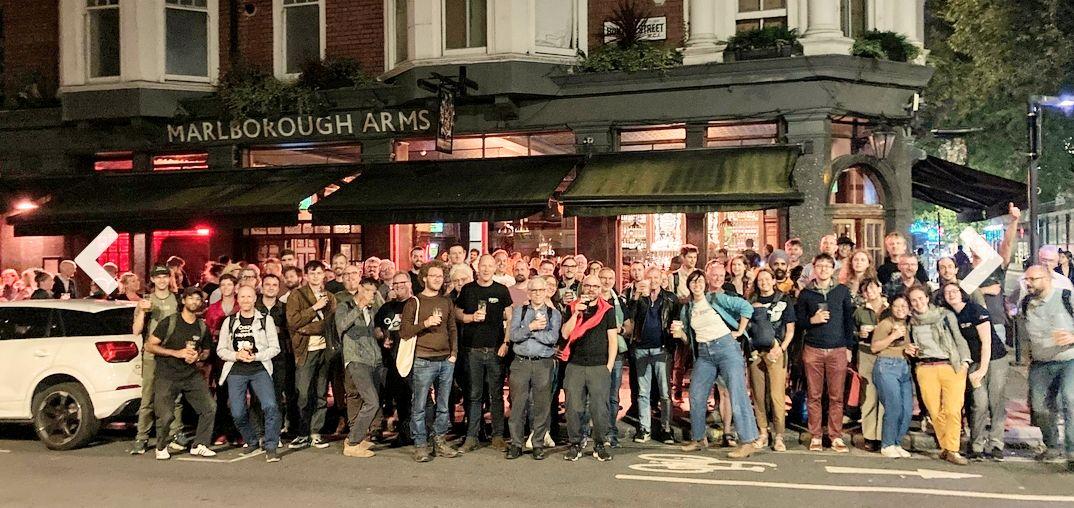
| London Borough of Camden | London pub meet-up | 2024-10-07 |  | |
| 中正區 | OpenStreetMap x Wikidata Taipei #69 | 2024-10-07 |  | |
| München | Münchner OSM-Treffen | 2024-10-08 |  | |
| Ifẹ̀ | State of the Map Nigeria 2024 | 2024-10-09 – 2024-10-11 |  | |
| Lorain County | OpenStreetMap Midwest Meetup | ✓ | 2024-10-10 |  |
| Bochum | Bochumer OSM Treffen | 2024-10-10 | | |
| OSMF Engineering Working Group meeting | 2024-10-11 | |||
| København | OSMmapperCPH | 2024-10-13 |  | |
| Missing Maps London: (Online) Mid-Month Mapathon [eng] | 2024-10-15 | |||
| Lyon | Réunion du groupe local de Lyon | 2024-10-15 |  | |
| Bonn | 181. OSM-Stammtisch Bonn | 2024-10-15 | | |
| San Jose | South Bay Map Night | ✓ | 2024-10-16 | |
| Salt Lake City | OSM Utah Monthly Map Night | 2024-10-17 | | |
| Karlsruhe | Stammtisch Karlsruhe | 2024-10-16 | | |
| Atelier Pifomètre/Bano | 2024-10-16 | |||
| Bruxelles – Brussel | Velopark mapathon @ Fietsberaad offices | 2024-10-17 |  | |
| Hannover | OSM-Stammtisch Hannover | 2024-10-18 | | |
| Karlsruhe | Karlsruhe Hack Weekend October 2024 | 2024-10-19 – 2024-10-20 | | |
| Pamplona/Iruña | GeoCamp ES | 2024-10-19 |  | |
| Cabecera Municipal Duitama | Estado del Mapa – Duitama 2024 | 2024-10-19 |  | |
| Nonnweiler | Craftmapping Höckerlinie Otzenhausen | 2024-10-19 | | |
| [Online] 18th Annual General Meeting of the OpenStreetMap Foundation | 2024-10-19 |
Nota: Quer ver seu evento publicado aqui? Então adicione-o no OSM Kalender calendário. Apenas os dados que forem inseridos lá aparecerão no weeklyOSM.
Este semanárioOSM foi produzido por AdrieleSBernardo, Lívia Rios, Raquel Dezidério Souto, Strubbl, TheSwavu, derFred, rtnf.