týdeník OSM 847
Pokud chcete pomoci s jeho překladem, ozvěte se na weekly@openstreetmap.cz. Děkujeme.
08/10/2026-14/10/2026
Mapping
- Two tagging proposals, related to graffiti, are open for voting until 26 October 2026. Evyy is proposing a dedicated tag,
shop=graffiti, for shops specialising in spray cans, markers, stickers, and other street art supplies, which have often been tagged asshop=craftorshop=paintin the past. Flappiegrrr is proposing to useleisure=graffiti_wallto record places where graffiti may be sprayed legally, and to describe individual walls using the keygraffiti_wall=*.
Community
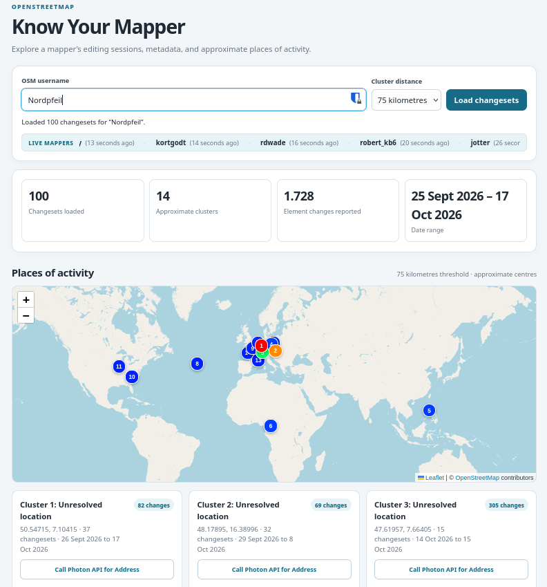
[1] Altilunium has developed ‘Know Your Mapper’, a web app that explores an OSM mapper’s editing sessions and approximate areas of activity.
The small team behind OpenClimbing: Jan Václavík, Pavel Zbytovský, and Fabian Weisshaar, have created their second bot proposal to clean up climbing-related tags in OpenStreetMap. Running with assistance from Mateusz Konieczny, the bot aims to improve the consistency and quality of OSM climbing data. OpenClimbing uses this information to power its specialised map with integrated topos for the climbing community.
Keagan van Rooyen described how he decided to contribute code to the CoMaps project and is currently working on several additional features for the Android Auto platform.
Events
Sozialheld*innen has developed the a11y-Score, a score that makes the accessibility of public services in any chosen region comparable, based on open data from OpenStreetMap (we reported earlier). They will be presenting it at an online event on Monday 26 October 2026, from 14:00 to 15:00 CEST.
Open Energy Transition will host a one-hour webinar introducing EarthPV, a tool that combines free Sentinel-2 imagery, the TerraMind geospatial foundation model, OpenStreetMap, open building datasets and human mapping to identify rooftop and ground-mounted solar installations above 10 kWp. The webinar will present the methodology and prototype results using Pakistan as a case study, and explain how the globally applicable workflow can support other contexts and research.
Stefan Keller announced ► that there will be a PostGIS and PostgreSQL course on 5 and 6 November 2026 at OST’s Rapperswil campus in Switzerland. The two-day practical course covers PostGIS database administration, data import and conversion, spatial SQL, modern SQL features, performance tuning, and extensions such as pgRouting and pgVector.
The eighth State of the Map Latin America will take place in person in Mexico City, Mexico, from 27 to 29 October 2026. You can find the full session schedule here .
OSM research
- HeiGIT presented a new paper introducing ACTION, a framework for making remote sensing and volunteered geographic information, including OpenStreetMap data, more useful for decision-making. The paper explored how combining satellite observations with local knowledge can support more transparent, reliable, and actionable geospatial workflows.
Maps
Eugene Muravjev has built an interactive 3D map of Yas Island. The map uses OpenStreetMap data for roads, buildings, parks, and shorelines, supplemented by building footprints from Overture and Microsoft, and vegetation data from Copernicus Sentinel and ESA WorldCover. Major landmarks, including Ferrari World, Yas Waterworld, Etihad Arena, and the F1 circuit plus its tunnels, are modelled by hand using photographs.
Goldilocks Map shows how many days a year the weather matches your own idea of comfortable (temperature range, humidity limit, and sunshine) for every place on Earth. The interactive map is built with MapLibre GL JS on OpenFreeMap tiles (OpenStreetMap data) and its climate numbers are checked against NOAA station records.
Historic.place has been migrated from OpenLayers 2 to Leaflet (via Forum ).
The Milan City Council’s Citizens’ Advisory Committee on Active Mobility and Accessibility has created a uMap showing all the cycle racks in the municipality of Milan.
Sven Geggus added support for shelters, except those with
sleeping=no, to OpenCampingMap (via Mastodon).The Birding Discovery team has developed birding.live, a free website that helps users discover common bird species and nearby birding locations worldwide using OpenStreetMap data.
TectonicPlateMap.org launched an global interactive web map built with MapLibre GL JS and OpenStreetMap vector tiles. The web app visualises all 52 tectonic plates from the PB2002 dataset, active fault lines, real-time USGS earthquakes, and Smithsonian GVP volcanoes.
Vienna Living Map is a free housing map of Vienna built on OpenStreetMap: Protomaps vector tiles, OSM points of interest, and cycleways. For every address it calculates the hours of direct sun per floor from OSM building outlines and the City of Vienna’s measured roof model.
OSM in action
Rasmus Jaakonmäki released Fontavio, an app that maps drinking water, refill taps, toilets, showers, self-service laundries, dump stations, and marina pump-outs across Europe, USA, and Canada. The data come from various sources, including OpenStreetMap, national open datasets, and places added directly by Fontavio users. Each place records its source while the OpenStreetMap data are credited under the ODbL licence.
The ALIS Project is developing ALIS, an open-source survival game set in real cities. In its latest prototype, the team has built a virtual Manhattan using Unreal Engine 5 and OpenStreetMap data, featuring 109,486 buildings, 84,096 road segments, and 28,265 trees.
Open Data
- Wikimedia Enterprise has released an open geospatial dataset that contains 17 million OpenStreetMap elements linked to Wikidata, Wikipedia, and Wikivoyage, as Parquet and GeoParquet files on Hugging Face and Kaggle.
Software
Jake Low reported several MapRoulette security vulnerabilities that exposed OpenStreetMap access tokens, API keys and users’ email addresses. He took the application offline for around 15 hours, revoked all credentials and released version 4.11.0 with fixes on 7 October. Users must sign in again and re-authorise MapRoulette with OSM, but do not need to change their passwords.
OpenHistoricalMap’s vector tiles have had many improvements over the past few months, including Simple 3D Buildings, goodies for golf mappers, and non-
administrativeboundaries (such as time zones, dioceses, and self-governing indigenous territories). Some of these are breaking changes for existing third-party stylesheets.Chris has been developing an AI-assisted OpenStreetMap mapping tool for Windows using Rust, Python, and WGPU for 3D features, with SAM 3 and YOLO models to detect features in satellite imagery from multiple sources, and is seeking community feedback.
Felis Pimeja has been working on the OSM Simple 3D Editor, a browser-based editor for OpenStreetMap buildings and indoor objects.
Martin Lange has developed TRAMP (Track and Route Analysis, Mapping and Planning), a free and open-source desktop application for Windows, Linux, and macOS that allows users to explore GNSS tracks and plan routes on OpenStreetMap-based maps using Valhalla or OSRM for routing and Photon or Nominatim for search.
HeiGIT introduced the Sketch Map Tool on LinkedIn, a low-tech solution to support community mapping through offline data collection, digitisation, and georeferencing of local information. The tool enables users to create and analyse paper-based maps using OpenStreetMap data and satellite or drone imagery from OpenAerialMap.
Releases
Over the past months Johan Morganti has been building a tool to explore every OpenStreetMap changeset since 2005, see trends over time, and drill down to who did what. This tool ingests OSM’s minutely changeset and diff replication from planet.osm.org, plus the full changeset history: 190 million changesets and 19 billion object changes, from 2005 to a few minutes ago.
HeiGIT announced the release of ohsome 2.0, introducing major improvements to the ohsome API, ohsome quality API, and dashboard for faster analysis and extraction of historical OpenStreetMap data. The article highlighted the new features and provided guidance for migrating from v1 to v2.0 before the legacy services are discontinued on 30 November 2026.
Other “geo” things
Safwat Halaby developed maplibre-gl-three, a library that enables developers to add 3D models and 3D tiles at geographic locations in MapLibre GL JS.
Working with voluntary and community organisations for some is a very important way to do geography. In a guide published by the Royal Geographical Society, there are case studies done in collaboration with community and voluntary organisations. The PDF is available.
Open Geospatial Solutions has developed RustGIS, a free and open-source GIS in pure Rust for mapping, analysing, and sharing geospatial data.
GMX reported how a couple got lost in Lost Dutchman State Park in the US state of Arizona after using Google Maps. The pair later called for rescue and were airlifted out by helicopter. In a similar incident, one person died in Yogyakarta, Indonesia, after a car carrying 16 people veered off the road while attempting to navigate a steep incline, following directions from Google Maps.
The United Nations Office for Disaster Risk Reduction has developed the STOP DISASTERS game. Through play, users explore how decisions about where people live, how buildings are constructed, how ecosystems are protected, and how communities prepare affect what happens when a hazard strikes. The game was originally made as part of the 2006–2007 World Disaster Reduction Campaign, ‘Disaster Risk Reduction Begins at School’.
The Tiroler Tageszeitung reported (paywalled) on a rival’s map, which has assigned names to places, mountains, and paths in Tyrol and Bavaria that nobody in the local area recognises, such as the ‘Schmusbichl’ in Kaunerberg. Local historians and the Tyrolean Nomenclature Commission are having to use old maps to fight against renaming at the click of a mouse. Donald Trump would probably welcome this as a model to follow; after all, he too has shown that a golf course can quickly be given a new name if you just have the right map in hand. In OpenStreetMap, by contrast, names continue to be assigned based on local knowledge.
Upcoming Events
| Country | Where | Venue | What | When |
|---|---|---|---|---|
| 🇧🇪 | Gent | TomTom Belgium | Maptime Ghent  | 2026-10-19 |
| Missing Maps London Mid-Month for Advanced Mappers (no training provided) (Online) [eng] | 2026-10-20 | |||
| 🇫🇷 | Lyon | Tubà | Réunion du groupe local de Lyon | 2026-10-20 |
| 🇩🇪 | Bonn | Dotty’s | 205. OSM-Stammtisch Bonn | 2026-10-20 |
| 🇩🇪 | Chemnitz | Kaffeesatz, Chemnitz | OSM-Stammtisch Chemnitz | 2026-10-20 |
| 🇬🇧 | City of Edinburgh | Guildford Arms | Edinburgh Social | 2026-10-20 |
| 🇩🇪 | Online | Lüneburger Mappertreffen (online) | 2026-10-20 | |
| 🇫🇷 | MJC de vienne | Réunion du groupe local de Vienne | 2026-10-21 | |
| 🇮🇹 | Milano | Formazione Wikimedia Italia - OpenStreetMap: modifica tramite sito e tramite app | 2026-10-21 | |
| 🇩🇪 | Karlsruhe | Schwarzer Kater | Stammtisch Karlsruhe | 2026-10-21 |
| OSM US Mappy Hour: Mapping Accessible Trails | 2026-10-21 | |||
| 🇬🇷 | [Online] OSM Greece - Διαδικτυακή συνάντηση της ελληνικής κοινότητας | 2026-10-21 | ||
| pk | CUI Islamabad | Training on OpenStreetMap (OSM Pakistan) | 2026-10-22 | |
| 🇩🇪 | Berlin | Online | EarthPV: Mapping Photovoltaics | 2026-10-22 |
| 🇸🇰 | Bratislava | Prírodovedecká fakulta UK Bratislava | Missing Maps mapathon Bratislava #14 | 2026-10-22 |
| 🇮🇳 | Ernakulam | Edapally, Kochi | Kochi Mapping Party 2026 | 2026-10-24 - 2026-10-25 |
| 🇮🇹 | Bologna | Liceo Copernico di Bologna | Linux Day 2026 a Bologna | 2026-10-24 |
| 🇮🇹 | Parma | Officine On/Off Parma | Linux Day 2026 Parma | 2026-10-24 |
| 🇫🇷 | Inclu K’fé | Cartopartie à Orx | 2026-10-24 | |
| 🇩🇪 | Berlin | Wikimedia e.V. Tempelhofer Ufer 23-24,10963 Berlin | OSM Hackweekend Berlin-Brandenburg 10/2026 | 2026-10-24 - 2026-10-25 |
| 🇸🇪 | Uppsala | Datorföreningen Update | Mapping meetup in Uppsala | 2026-10-25 |
| 🇮🇳 | Noida | Noida | OSM Delhi NCR Mapping Party No.33 (Noida) | 2026-10-25 |
| a11y-Score: ein OSM-Barrierefreiheitswerkzeug | 2026-10-26 | |||
| CartONG : Mapathons en ligne 2026-2027 | 2026-10-26 | |||
| 🇮🇹 | Milano | Formazione Wikimedia Italia - OpenStreetMap: tasking manager | 2026-10-26 | |
| 🇩🇪 | Stadtgebiet Bremen | Online und im Hackerspace Bremen | Bremer Mappertreffen | 2026-10-26 |
| 🇩🇪 | Heidelberg | DEZERNAT#16 | Rhein-Neckar OSM Treffen | 2026-10-26 |
| 🇲🇽 | Ciudad de México | Antiguo Colegio de San Ildefonso | State of the Map Latam 2026 | 2026-10-27 - 2026-10-29 |
| Pravidelný Missing Maps CZ-SK online Mapathon | 2026-10-27 | |||
| 🇦🇹 | Wien | Schlupfwinkel (Kleine Neugasse 10, 1040 Wien) | 80. Wiener OSM-Stammtisch | 2026-10-27 |
| 🇬🇧 | Derby | The Brunswick, Railway Terrace, Derby | East Midlands pub meet-up | 2026-10-27 |
| 🇩🇪 | Düsseldorf | Online bei https://meet.jit.si/OSM-DUS-2026 | Düsseldorfer OpenStreetMap-Treffen (online) | 2026-10-28 |
| 🇩🇪 | Würzburg | FabLab Würzburg | Würzburger OSM-Treffen | 2026-10-28 |
| 🇨🇭 | Rapperswil-Jona | OST RJ Gebäude 6, Rapperswil | 20. Mapathon & Mapping Party Rapperswil 2026 | 2026-10-30 |
| 🇮🇹 | Pesaro | Biblioteca-Archivio “Vittorio Bobbato” | Linux Day 2026 in Pesaro | 2026-10-31 |
| 🇮🇹 | Pesaro | Biblioteca-Archivio “Vittorio Bobbato” | Linux Day Pesaro | 2026-10-31 |
| 🇮🇳 | नई दिल्ली | Jitsi Meet (online) | OSM India - Monthly Online Mapathon | 2026-11-01 |
| 🇩🇪 | Hannover | Kuriosum | Stammtisch | 2026-11-02 |
This weeklyOSM was produced by Aphaia_JP, Elizabete, HeiGIT, MarcoR, MatthiasMatthias, Nakaner, Raquel Dezidério Souto, Strubbl, Andrew Davidson, barefootstache, derFred.
We welcome link suggestions for the next issue via this form and look forward to your contributions.
Toto číslo přeložil tom.k a redakčně upravil mkyral. Budeme velmi rádi, pokud podpoříte a oceníte naši práci tím, že budete dílo dále šířit, např. sdílením na sociálních sítích (like, retweet, boost...). Předem za to děkujeme.
Každé číslo v CZ verzi je promováno zde: 🦣 @osmcz | ✉️ Talk-cz | ✉️ osm_sk | 🛜 rss
Můžete nás kontaktovat e-mailem:
weekly@openstreetmap.cz
Nechte reakci