OSM Mingguan 849
We are looking for volunteers to help us translate! Please get in touch with us: info@weeklyOSM.eu
22/10/2026-28/10/2026
Mapping
Andy Mabbett has proposed a tagging scheme for the concrete arrows and illuminated beacon towers along the historic US Transcontinental Airway System. These physical navigation aids were built to guide early airmail pilots. Concrete arrows were enormous arrows painted or laid out on the ground, often on hilltops or open land, pointing pilots towards the next route segment. Beacon towers were tall structures equipped with powerful lights that helped pilots follow the route at night.
LordGarySugar is proposing the tags
flat_ride=trackandwater_ride=trackso that, in the case of flat rides and water rides, the track can be distinguished from the ride area. Currently,attraction=log_flumeis used for both, meaning that renderers cannot interpret the tag on paths. The tagattraction:part=*is intended to identify components such as stations and platforms, whilst asite=attractionrelation is intended to link all parts of an attraction. The discussion is taking place on the OSM Community forum.
Community
rtnF has analysed the diversity of
addr:neighbourhoodvalues in Indonesia.simaransharma has been adding and fixing temple map data in Surat, Gujarat, and is currently looking for other mappers in Gujarat who are also interested in mapping temples.
Local chapter news
- OSM US published another instalment of their Mapper Highlight series, which highlights mappers, projects, and OSM communities. This October, they interviewed William Edmisten (aka wcedmisten), a Virginia mapper who recently mapped every hospital network in the United States and kept invested followers updated on the OSM US Slack.
Events
As part of its Gender Programme, the Unique Mappers Network hosted a virtual breast cancer awareness and geospatial education event on Friday 23 October. The theme was ‘Every Story Is Unique, Every Journey Matters’. It covered breast cancer awareness, prevention, early detection, and the importance of seeking medical advice. It also looked at the role of open mapping in community health awareness.
The organisers of the fifth State of the Map Nigeria have postponed their conference from 10 to 13 November to 17 to 20 November 2026, as the University of Uyo has scheduled its graduation ceremony for 9 to 14 November. The venue remains the Town Campus of the University of Uyo in Akwa Ibom State, and the theme remains ‘Open Geospatial Innovation for Climate Action and Community Resilience’. The programme includes workshops, specialist talks on GeoAI, OpenStreetMap, citizen science, and climate action, as well as networking opportunities. Further information can be found on the conference website.
The Asociación OpenStreetMap España is hosting ‘SotMes 2026’ at the TomTom offices in Madrid on 6 and 7 November. This free gathering of the Spanish OSM community combines talks with an ‘unconference’. Anyone interested can register .
Maps
The Cunning Conquests Atlas is a free resource containing interactive maps of an ever-growing library of journeys. It was built with coastline data from OpenStreetMap and was released on 17 October. You can also watch the videos on YouTube with detailed legends.
Proton built a web map where you can look up any ZIP code in the US and find how many surveillance devices (flock cameras) are near your home. The device locations on this Flock camera map come from independent research by cybersecurity researcher Joshua Michael.
vetsurgeo launched The Church Atlas, a free map of more than 3,000 churches in 18 languages, using OpenStreetMap data, with Wikidata and Wikipedia providing addresses, summaries, and photos. He also shared the lessons learned about church tagging in a diary entry.
rpollock has published Walkably, a map showing pedestrian-friendliness across 31 European countries, based on OpenStreetMap data. Each hexagonal cell that intersects a road is assigned a score for the walkability of everyday destinations and for road quality (traffic, noise, shade in summer, main roads, gradient). An OSM blog post documented the checks made against census data. The full methodology is explained on the project page.
OSM in action
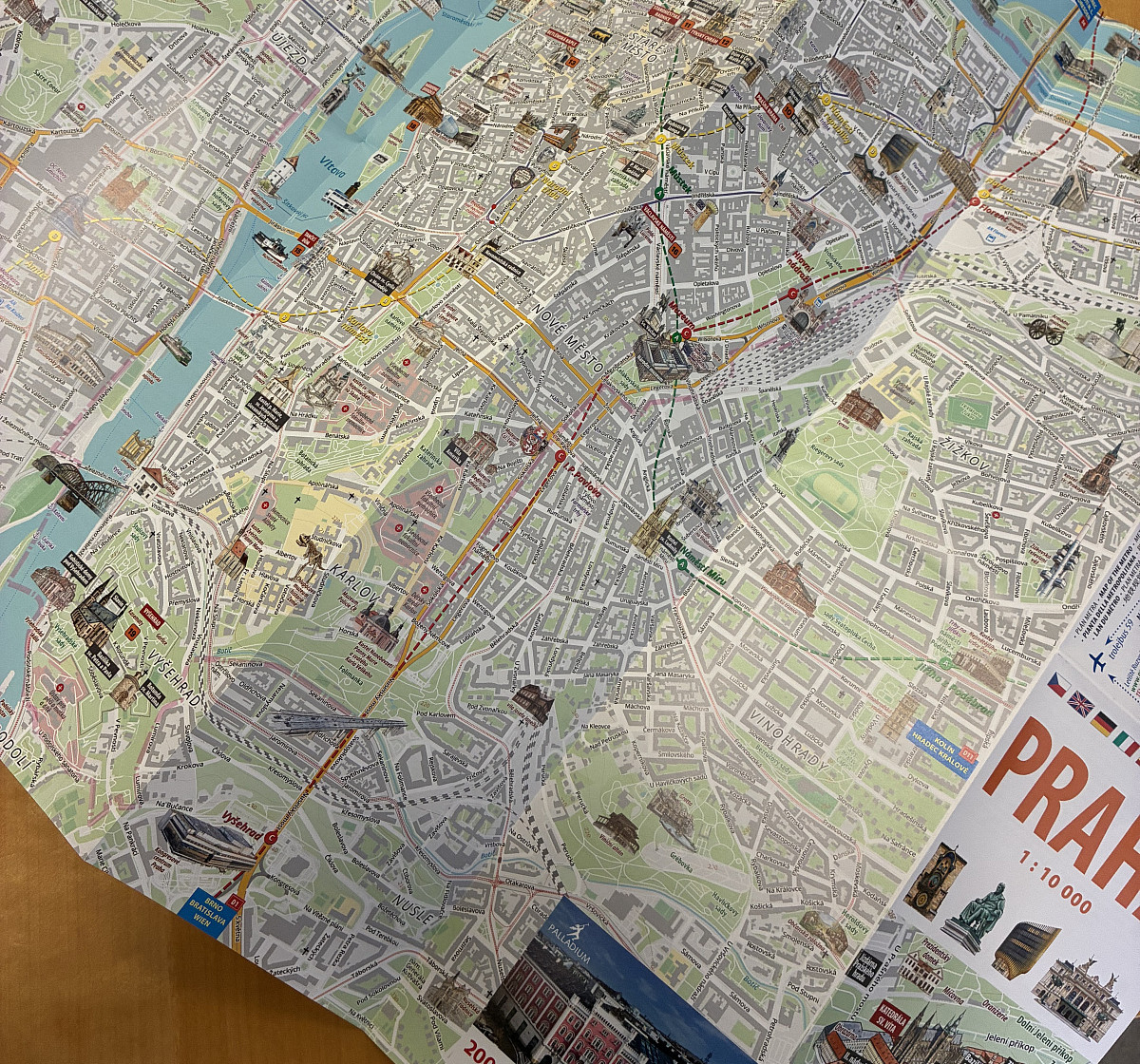
[1] Jiri Podhorecky worked on the graphic design and cartographic preparation of a printed tourist map of Prague, built directly on up-to-date OpenStreetMap data.
copilot.travel developed a dynamic map that shows each European capital claiming territory on the basis of the nationality of the first car to reach surrounding places, using typical road speeds and including ferries.
Software
Chris Debian has developed PillarPoint, an open-source Android app for people who find, visit, and record British trigonometrical points (trigs) and Ordnance Survey benchmarks. For each trig the app checks whether OSM already has a matching survey point and flags any OSM node that is some distance from the recorded station location.
GeoDesk released GOL Tool 2.5, adding support for incremental updates to keep local copies of OpenStreetMap data up to date.
Martin Faust has built Rücksitzhelden, a free app for families on long car journeys that shows ► attractions and family-friendly restaurants along the route using OpenStreetMap data.
Axel Piepgras has developed ► rueckenwind, an iPhone bicycle navigation app powered by OpenStreetMap data.
The well-known ‘Strava Slide’ algorithm, which allows drawn routes to be automatically adapted to and optimised for the Strava heatmap, is now available both as a browser extension ‘strava-heatmap-extension’ for Chrome and Firefox, or a JOSM plugin ‘josm-strava-tracer’. This tool allows the geometry of routes to be captured much more quickly and accurately based on aggregated GNSS tracks.
Ukrainian developers Vladyslav and Daryna Shinkarenko have developed Орієнтир, an iOS navigation app that works without GNSS. Instead, the app uses smartphone sensors to estimate the car’s speed and turns. It also offers offline maps of the whole of Ukraine, powered by OpenStreetMap data.
Victor explained how OsmAnd’s new search engine, built from scratch and recently released in version 5.5, works.
Programming
- anthaas described how he automated marking small tasks, related to the Ebola campaign in the Democratic Republic of the Congo, as done in the HOT Tasking Manager using JOSM and the TM API.
Releases
- HeiGIT has introduced a new openrouteservice web client, which replaces the two previous route planners. This article explains the new features, current limitations, and what users need to know before the old clients and deprecated API URL are shut down on 16 November.
Did you know that …
- … the Magic Earth navigation app is based on OpenStreetMap data? It offers turn-by-turn navigation, offline maps, and speed camera alerts for iPhone, iPad, and Android; navigation is free, whilst additional features are available via a freemium model. The source code is not open. mobilsicher.de tested the Magic Earth navigation app back in 2019 and gave ► it a positive review (we reported earlier).
Other “geo” things
Geografías acuáticas: espacios de conectividad y sociabilidad, edited by Guadalupe Pinzón Ríos and Flor Trejo Rivera and published by the Universidad Nacional Autónoma de México, demonstrates how aquatic environments, rather than being peripheral or serving as spaces that separate societies, should be viewed as settings for diverse forms of connectivity, and within which forms of social interaction were also established that are, in fact, of great significance in a region such as this, where bodies of water deserve greater attention.
Sven-Erik Volberg posted a map of the approximate historical boundaries of the larger European states (those with an area over 100,000 square kilometres). The map covers around 1500 years from 500 CE.
The Direção-Geral do Território has announced ► the ‘XVII Jornadas Ibéricas de Infraestruturas de Dados Espaciais’ (Iberian Conference on Spatial Data Infrastructure), to be held from 11 to 13 November in Porto, Portugal. Those interested can register ► now.
Upcoming Events
| Country | Where | Venue | What | When |
|---|---|---|---|---|
| 🇲🇽 | Ciudad de México | Antiguo Colegio de San Ildefonso | State of the Map Latam 2026  | 2026-10-27 - 2026-10-29 |
| 🇨🇭 | Rapperswil-Jona | OST RJ Gebäude 6, Rapperswil | 20. Mapathon & Mapping Party Rapperswil 2026 | 2026-10-30 |
| 🇮🇹 | Pesaro | Biblioteca-Archivio “Vittorio Bobbato” | Linux Day Pesaro | 2026-10-31 |
| 🇮🇳 | नई दिल्ली | Jitsi Meet (online) | OSM India - Monthly Online Mapathon | 2026-11-01 |
| 🇩🇪 | Hannover | Kuriosum | Stammtisch | 2026-11-02 |
| 🇭🇺 | Budapest | United Platforms, Fény utca 16. | OSM térképest – 2026 november | 2026-11-03 |
| Missing Maps London Mapathon Beginner Friendly (with Training) (Online) [eng] | 2026-11-03 | |||
| 🇨🇭 | Bern | Provisorium46 | Berner OpenStreetMap-Znacht | 2026-11-03 |
| 🇩🇪 | Stuttgart | Forum 3 Café | Stuttgarter OpenStreetMap-Treffen | 2026-11-04 |
| 🇫🇷 | Bar Le Schmilblik | Rencontre mensuelle des contributeurs Paris sud | 2026-11-05 | |
| 🇪🇸 | Madrid | TomTom, Edificio Aqua, Calle Agustín de Foxá 4 | State of the Map España 2026 (SotMes 2026) | 2026-11-06 - 2026-11-07 |
| 🇫🇷 | Angers | L’Arrière Train, 3 rue de Frémur, Angers | Angers Rencontre mensuelle OpenStreetMap | 2026-11-06 |
| 🇦🇹 | Salzburg | HTL Itzling | Maker Days Salzburg | 2026-11-07 |
| 🇮🇹 | Angera | Mapathon @ Angera | 2026-11-07 | |
| 🇩🇰 | København | Cafe Bevar’s | OSMmapperCPH | 2026-11-08 |
| CartONG : Mapathons en ligne 2026-2027 | 2026-11-09 | |||
| 🇹🇼 | 臺北市 | MozSpace Taipei | OpenStreetMap x Wikidata Taipei #94 | 2026-11-09 |
| 🇺🇸 | Salt Lake City | Woodbine Food Hall | OSM Utah Monthly Map Night | 2026-11-10 |
| 🇩🇪 | Hamburg | Voraussichtlich: “Variable”, Karolinenstraße 23 | Hamburger Mappertreffen | 2026-11-10 |
| 🇺🇸 | San Jose | Online | South Bay Map Night | 2026-11-10 |
| 🇬🇧 | City of Westminster | The Volunteer pub | London pub meet-up | 2026-11-10 |
| 🇩🇪 | temporärhaus | OSM-Stammtisch Ulm/Neu-Ulm | 2026-11-10 | |
| iD Community Chat | 2026-11-11 | |||
| 🇩🇪 | München | Echardinger Einkehr | Münchner OSM-Treffen | 2026-11-11 |
| OSM US Mappy Hour: Mapping Route 66 Past & Present | 2026-11-11 | |||
| 🇮🇳 | Kottayam | Kottayam, Kerala | State of the Map Kerala (SoTM Kerala) | 2026-11-14 - 2026-11-15 |
| 🇮🇪 | Dublin | 4 Inns Court, Winetavern Street, Dublin, D08 XY00 | OpenStreetMap Ireland AGM - 2026 | 2026-11-14 |
| 🇮🇳 | New Delhi | South Delhi | OSM Delhi Mapping Party No.34 (South Zone) | 2026-11-15 |
This weeklyOSM was produced by MatthiasMatthias, PierZen, Raquel Dezidério Souto, Andrew Davidson, barefootstache, derFred, vicksun.
We welcome link suggestions for the next issue via this form and look forward to your contributions.
Leave a reply