03/05/2022-09/05/2022
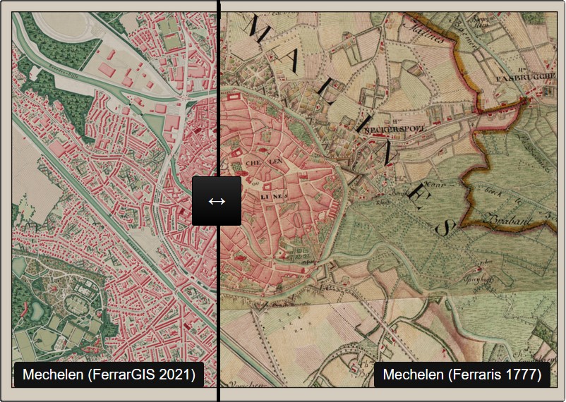
Mechelen, Belgium, styles: OSM-FerraGIS 2021 and Ferraris 1777 [1] © Manuel Claeys Bouuaert | map data © OpenStreetMap contributors
Mapping
- Pete Masters pointed out that Becky Candy’s feedback to mappers (we reported earlier) has been translated to Japanese and Spanish .
- Ikuzo is a POI oriented ‘map editor made specially for travel photographers, influencers and other content creators’ for categorising, filtering, sharing POIs and adding pictures to them. It is powered by OpenStreetMap. Unfortunately POIs are opened in Google Maps.
- The MapComplete theme for trees got an update to easily add wikidata for species to trees.
- User Frank, aka Dooley, has
 > taken the page OSMsuspects permanently offline. The page cannot be operated by other sites because of missing sources. User mmd suggested replacing > parts of it with the help of overpass queries.
 - A request for comments on a proposal for a consistent tagging scheme for highway networks belonging to sub-state administrative divisions of the USA has been made.
- Voting on the
amenity=ticket_validatorproposal, for tagging ticket validators, which are often required to gain access to an area or service like public transport or parking garages, is open until Tuesday 24 May.
 >
> 
Community
- The UN mapper of the month is Abdurahman Al Furjani, from OSM Libya.
- OpenStreetMap Belgium’s Mapper of the Month for May is Gpoilvet.
- Anne-Karoline Distel’s archaeological discovery that we reported last week has been picked up in the Irish media. ‘A lovely find’, says the National Monuments Service.
- The SotM 2022 Scientific Committee informed us that the deadline of the call for abstracts for the Academic Track has been extended to 22 May 2022.
- AngocA reported > on an introductory session about the OSM wiki that he gave on Saturday 23 April, and provided the video recording of the session, a PDF , along with the slides and a quiz to test your knowledge.
- The French association ‘Observatoire international pour la réinstallation des cabines téléphoniques‘ > (literally ‘International observatory for phone booth reinstallation’) has built > its first booth in Grenoble, France, and aims for a first objective of 22. This is an opportunity for the French mapping community to rediscover the
amenity=telephonetag. - Luisrobledomx1 invites > you to join the 3rd Latin America bi-monthly meeting, organised by OSM Chile, which will be held on Saturday 28 May and will be virtual.
- Université de Strasbourg (France) is using an online map based on OpenStreetMap to give directions on the university campus.
 >
>  >
> Local chapter news
- OpenStreetMap Belgium wrote a diary post about their open street-level imagery project. They are buying 360° cameras and lending them to volunteers to generate more and better street-level imagery as open data. They hope to not just collect data, but to also inspire others to start contributing. The project page is available in English, French and Dutch
Events
- State of the Map France 2022 released > its planning for the event taking place 10 to 12 June in Nantes.
- Enjoy excerpts from a 45 minute improvisation between Eric Theise, manipulating digital maps, and Helena Espvall, performing on cello with electronics.
- The list of publications from the last SotM US is getting longer. New videos on the OpenStreetMap US YouTube channel include:
- Martijn van Exel talking about MapRoulette
- Philipp Kandal and Alex Ilisei explaining that Grab uses OSM and how they generate images for Kartaview (formerly OpenStreetCam and OpenStreetView) to contribute to OSM.
- Steve Coast explaining the MapMetrics tool that TomTom introduced in 2021. He also demonstrated how to work with it. Furthermore he gave an outlook on ‘automatic road alignment’.
Education
- Christian Quest has published > a tutorial for French mappers interested in contributing streets to OpenStreetMap through comparison with the Institut National de l’information Géographique et Forestière (National Institute of Geographic and Forest Information) open database BDTopo.
- barefootstache shared a video showing advanced JOSM techniques to map buildings.
OSM research
- The International Journal of Geoinformation has gathered together 15 research papers for a special issue named ‘OpenStreetMap as a multi-disciplinary nexus: Perspectives, Practices and Procedures’.
Maps
- [1] Joseph Jean François, Count of Ferraris, created the ‘Carte-de-Cabinet’ of the Austrian Netherlands in his own style between 1771 and 1778. Manuel Claeys Bouuaert recreated Ferraris’ style in QGIS for use with OpenStreetMap data. In his blog post, Manuel described in detail how he proceeded and shows many beautiful examples. Using sliders you can compare the OSM ‘FerrarGis 2021’ and Ferraris 1777.
Software
- Organic Maps have released the April update for Android and iOS, which has improvements in support of Wikipedia articles, Euskara (Basque) translations, speed and battery optimisation. As usual, maps are updated, and routing and translations are improved.
- Anton Khorev wrote a diary entry about loose link detection in note-viewer, which will replace a plaintext URL with a dotted hyperlink. For now, it only handles openstreetmap.org and StreetComplete’s image hosting URLs, but other sites may be added in the future.
- garmin.openstreetmap.nl has not been fully functional for some time, so now an automatic redirection to an alternative service of bbbike.org is now in place.
- ‘On The Go Map’ is a route planner for running, walking, biking, or driving, where you can plot your route points, see the elevation, and share the map – powered by OpenStreetMap.
- Balluchon > is a tool aiming to ease contributing to OpenStreetMap, putting a focus on pedestrian data. As of now, it allows adding and modifying entrances along buildings. A live demo is available here .
- Patrick Gendre created OpenMobilityIndicators, using open data to draw a map of sustainable mobility indicators.
- Vespucci is planning to remove support for Android 4.0.1 to 4.0.4 (released in 2011) devices in version 18 (fall 2022). People still using such devices, with a private instance of the OpenStreetMap API, are asked to contact the Vespucci team.
- xrisnik shared a JOSM preset for adding addresses to houses.
Programming
- Hans Hack tweeted about his beta release of ‘a geoprocessing tool to handle GeoJSON files fast and simple’. It allows the processing of GeoJSON files in an if-this-then-that manner. For example ‘Remove this:<Berlin.geojson> from that:<Germany.geojson>’. There are ‘sentences’ that find shared geometries (areas), dissolve areas in other areas and repair GeoJSON files.
- Jean-Marie Favreau has released > the source code for OSM Tag Challenge. Each day, the Twitter bot posts pictures of a place from a Flickr album without context and challenges us to ‘reflect on OpenStreetMap’s ontology’.
Releases
Did you know …
- … Acastus-Photon, an address and POI lookup application for Android based on OpenStreetMap data? Available through F-Droid, the app is said to be more reliable than other POI lookup solutions thanks to using Photon, developed by the Komoot team, as its default backend.
- … how to create a layer highlighting a custom POI type in OsmAnd?
- … Volodymyr Agafonkin, creator of Leaflet, has explained the most important steps for rendering map tiles in a tutorial? This tutorial and much more (including a ‘sourdough calculator‘) can be found on his ‘Notebooks’ page.
OSM in the media
- Amy Flaming, from The Guardian, reported on secondary school teacher Michael Shanks, who has had the satisfaction of having drawn GPS lines over all 6,000 streets of his city Glasgow, and other people equally motivated to reach their own target of travelling every street in their city.
Other “geo” things
- Taylor Brooker has made an unusual and beautiful hand crafted map as a wedding present.
- HouseFresh gathered up Google search data from 2021 and created a map of the world’s houseplants based on each country’s most popular species.
Upcoming Events
| Where | What | Online | When | Country |
|---|---|---|---|---|
| Lyon | Rencontre mensuelle Lyon | 2022-05-17 |  | |
| 151. Treffen des OSM-Stammtisches Bonn | 2022-05-17 | |||
| Lüneburg | Lüneburger Mappertreffen (online) | 2022-05-17 |  | |
| Zürich | Missing Maps Zürich Mapathon | 2022-05-18 |  | |
| Montmorillon | Printemps des Cartes | 2022-05-19 – 2022-05-22 | | |
| Olomouc | květnový olomoucký mapathon | 2022-05-19 |  | |
| Kaskazini B | Tanzania Mapping Groups May Mapathon | ✓ | 2022-05-21 |  |
| 京都市 | 京都!街歩き!マッピングパーティ:第30回 相国寺 | 2022-05-22 |  | |
| 臺北市 | OpenStreetMap街景踏查團工作坊2 | 2022-05-22 |  | |
| [Online] OpenStreetMap Foundation board of Directors – public videomeeting | 2022-05-23 | |||
| OSMF Engineering Working Group meeting | 2022-05-23 | |||
| Bremen | Bremer Mappertreffen (Online) | ✓ | 2022-05-23 | |
| San Jose | South Bay Map Night | ✓ | 2022-05-25 |  |
| City of Nottingham | OSM East Midlands/Nottingham meetup (online) | ✓ | 2022-05-24 |  |
| Düsseldorf | Düsseldorfer OpenStreetMap-Treffen | ✓ | 2022-05-25 | |
| Santiago | 3a reunión bimestral de OSM Latam | 2022-05-28 |  | |
| Town of Victoria Park | Social Mapping Sunday: East Vic Park | 2022-05-29 |  | |
| Bruxelles – Brussel | Virtual OpenStreetMap Belgium meeting | ✓ | 2022-05-31 |  |
Note:
If you like to see your event here, please put it into the OSM calendar. Only data which is there, will appear in weeklyOSM.
This weeklyOSM was produced by Lejun, MatthiasMatthias, Nordpfeil, PierZen, SK53, Sammyhawkrad, SomeoneElse, Strubbl, TheSwavu, cafeconleche, derFred, fazlerabbi37, tordans.
> Photon, developed by the Komoot team
initially this was correct, but since years it is developed by Sarah (maintainer of Nominatim too) and the community. See nominatim.org