Notiziario Settimanale OSM 845
24/09/2026-30/09/2026
Chi siamo
- Siamo felici di annunciare che weeklyOSM è ora accessibile anche su news.osm.org, per dare uguale spazio alle voci e ai contributi della nostra comunità globale. Il nuovo dominio reindirizza a weeklyOSM.eu
Progetti di mappatura
- Il 1° ottobre, Eugene Alvin Villar ha annunciato la sfida “31 Days OSM Challenge”, proposta dal Gruppo di lavoro sui capitoli locali e le comunità della Fondazione OpenStreetMap. Dai un’occhiata alle sfide quotidiane e ricorda che non è necessario contribuire ogni giorno.
Comunità
Raquel Dezidério Souto racconta nel suo diario utente OSM di aver curato due nuovi volumi del libro Case Studies in Collaborative and Participatory Mapping (uno dei quali è un dossier tematico sulla riduzione dei rischi e delle catastrofi), in portoghese. Ha scritto alcuni capitoli sull’applicazione di OpenStreetMap in due casi di studio condotti in collaborazione con il Ministero brasiliano dell’Integrazione e dello Sviluppo Regionale (parte del volume 2). In totale sono stati pubblicati 35 capitoli e i due e-book sono disponibili in accesso libero sul portale della Editora IVIDES.
Nella 248ª puntata del podcast “Libre à Vous”, Anne L’Hôte ha presentato una rubrica intitolata “Completa la tua strada”.
In un post sul blog, Christoph Hormann (imagico) riflette sulle sfide della comunicazione all’interno delle comunità open source come OpenStreetMap. Sottolinea come le barriere linguistiche, i diversi contesti culturali e le peculiarità della comunicazione digitale basata sul testo possano portare ripetutamente a malintesi nelle discussioni, e invita a una maggiore comprensione e attenzione in questi scambi.
L’utente di Reddit u/Legitimate-Weight768 sta mappando la sua città natale , Marcílio Dias, a Canoinhas, nello Stato di Santa Catarina, in Brasile, e sta chiedendo su Reddit qualche consiglio su come migliorare le sue abilità di mappatura con OSM.
Il gruppo di utenti Wikimedia Ghana ha organizzato l’evento “Wiki Loves Places 2026” in Ghana, con l’obiettivo di raccogliere almeno 250 immagini geotaggate di luoghi, documentare 250 nuove entità geografiche su Wikidata e aggiungere o aggiornare 250 località su OpenStreetMap.
Sul forum della comunità OSM è stata creata una categoria locale per il Kalaallit Nunaat (Groenlandia).
9_tab parla di Planet Trails in Svizzera . Quanti ce ne sono su OSM? Quanto è dettagliata la mappatura? Che scala usano? Includono Plutone? Cos’altro? Quali sentieri potrebbero mancare?
OpenStreetMap Foundation
Dorothea Kazazi ha annunciato che i programmi elettorali dei candidati al consiglio dell’OSMF e le risposte alle domande ufficiali poste da Brian Sperlongano sono ora disponibili sul Wiki di OSM .
Christoph Hormann ha parlato delle prossime elezioni del consiglio dell’OSMF del 2026, affermando che avere quattro candidati per quattro seggi rende l’elezione “priva di significato” e potrebbe compromettere seriamente la legittimità del consiglio come rappresentanza democraticamente eletta dei membri dell’OSMF.
Notizie sui Local Chapters
OpenStreetMap US ha pubblicato la newsletter di settembre 2026.
InsertUser ha spiegato come i mappatori OSM del Regno Unito possano votare per il prossimo progetto trimestrale del Regno Unito fino al 28 settembre.
Eventi
Il Centro Argentino de Cartografía (CAC) ha pubblicato su LinkedIn un promemoria in cui ricorda che il termine ultimo per iscriversi al 13° Congreso de la Ciencia Cartográfica – che è anche il 4° Congreso Virtual Internacional – è il 30 settembre 2026. Il congresso virtuale si terrà dal 6 all’8 ottobre 2026 ed è organizzato congiuntamente dal CAC e dall’Instituto Geográfico Nacional (IGN) argentino.
Alpha Amadou Diallo ha riferito che il comune di Pire Goureye, in Senegal, ha ospitato un corso di formazione sulla mappatura collaborativa con OpenStreetMap dal 26 al 27 settembre 2026.
Educazione/Formazione
- Nelson Gonçalves ha pubblicato del materiale didattico che introduce alla cartografia web e a uMap.
OSM research
- Thiago Kikuchi e i suoi colleghi hanno sviluppato una mappa interattiva uMap che mostra l’ambiente fisico dei bacini fluviali urbani nel Paraná settentrionale, in Brasile, combinando dati disponibili pubblicamente su curve di livello, pendenze, tipi di suolo, idrografia, corpi idrici, sorgenti e confini dei bacini idrografici.
Mappe
Mark Dimond usa OSMnx per vedere quale strada in Inghilterra è quella più trafficata dagli autobus.
Martin ha creato una mappa che mostra quale konbini è più vicino a te a Tokyo e quale catena domina in ogni zona, utilizzando i dati di OpenStreetMap.
NoEscapeMap ha sviluppato NoEscape 2.0, una mappa web che geocodifica i casi passati di tentativi di attraversamento del confine, attingendo dai dati pubblici dei registri giudiziari ucraini, con l’obiettivo di aiutare turisti e ricercatori ad analizzare i rischi ed evitare pericoli .
Stamen Design ha spiegato come il suo partner Stadia Maps abbia aggiornato i dati di base utilizzati in diverse mappe di fondo di Stamen, concentrandosi su una revisione completa degli elementi idrografici come fiumi, laghi e linee costiere.
Map Amore ha presentato “The Arrogance of Space Mapping Tool” , uno strumento che mostra quanto spazio occupano le auto nelle nostre città.
Ogmios ha creato il sito web World Wide Waterways: Flussdiagram.me , dove i corsi d’acqua vengono rappresentati su mappe 1D con metadati aggiuntivi provenienti da OpenStreetMap e Wikidata.
OSM in azione
Sozialheld*innen ha lanciato a11y-Score, uno strumento che rende visibile e comparabile l’accessibilità in Germania attraverso un punteggio da 0 a 100 per i Länder, i 418 distretti e le città autonome, nonché per la Germania nel suo complesso, sulla base dei geodati aperti di OpenStreetMap.
BoxThisLap parla di TerraDrive, un nuovo generatore di mappe open source che trasforma i dati di OpenStreetMap e quelli altimetrici in ambienti 3D percorribili. Rilasciato sotto licenza MIT, lo strumento utilizza la geometria stradale di OSM, i dettagli delle corsie, gli incroci e le sagome degli edifici per ricreare reti stradali realistiche, che possono poi essere esportate come livelli giocabili per il gioco di simulazione automobilistica BeamNG.drive.
Spino87 ha pubblicato PizzaRank, un elenco di 30.931 pizzerie italiane, di cui ben 24.000 provenienti da OpenStreetMap, e ha anche reso disponibile la parte relativa a OSM in formato .CSV o .JSON sotto licenza ODbL, dato che una semplice attribuzione non è sufficiente per un’opera derivata da un database. Sul forum ha chiesto consigli su come segnalare a OSM eventuali errori riscontrati durante il processo; parlando con Martin Koppenhöfer, è emerso che i duplicati e i nomi errati dei comuni erano dovuti a peculiarità dello strumento di esportazione osmium o del suo script, mentre sei pizzerie che hanno chiuso definitivamente dovrebbero ora essere segnalate singolarmente come note. I dati hanno inoltre rivelato che il tag
oven=wood_firedè stato usato pochissimo finora, motivo per cui entrambi suggeriscono di promuoverlo più attivamente tramite le impostazioni predefinite e una missione su StreetComplete.
Open Data
Dopo vent’anni di servizio, IGN France sostituisce Geoportail con il suo nuovo portale cartes.gouv.fr, pensato come punto di accesso unico alle mappe e ai dati geografici territoriali. L’obiettivo è rendere la mappa uno strumento digitale accessibile, aperto e utile sia per l’uso quotidiano che per le decisioni importanti, per semplici curiosi, escursionisti, rappresentanti politici locali o professionisti. Il portale contiene mappe dell’IGN e dei suoi partner, fotografie aeree e vari tipi di carte (catasto, foreste, storiche, topografiche, stradali, ecc.).
Jake Low ha annunciato che Layercake, una distribuzione dei dati di OpenStreetMap suddivisa in livelli tematici e convertita nel formato GeoParquet, ha un nuovo sito web.
Software
Tykayn presenta Qualiwiki, una dashboard web che permette di confrontare la copertura dei contenuti tra la versione inglese e quella francese del Wiki di OSM.
PapaMap mostra il fasciatoio più vicino che i genitori possono raggiungere grazie ai dati di OpenStreetMap ed è ora disponibile come app per iPhone, mentre la versione per Android è attualmente in fase di sviluppo.
Tobias Zwick ha annunciato la prima versione beta pubblica di StreetComplete per iOS.
Programmazione
HeiGIT presenta HeiSlime, un toolkit in Python che utilizza il contesto di OpenStreetMap per selezionare immagini utili all’analisi prima di elaborarle con un modello di visione artificiale. Il risultato è un insieme di immagini più piccolo e mirato che ti fa risparmiare tempo di elaborazione.
Gli amministratori di sistema dell’OSMF hanno segnalato su Mastodon che l’aggiornamento a Mapnik 4.3.2 ha portato a notevoli miglioramenti nelle prestazioni per il rendering delle tessere raster. Inoltre, ci sono miglioramenti tecnici a OSM Carto apportati da leijuv e nakaner. Puoi trovare spiegazioni dettagliate su GitHub. Un’altra pull request per OSM Carto, ancora non integrata, promette un ordinamento più efficiente delle entità.
Sarah Hoffmann riferisce sul forum che Kai Johnson ha migliorato il monitoraggio dell’utilizzo della CPU per singolo client su un server Overpass. Queste misurazioni servono a bloccare gli utenti che consumano troppe risorse in base all’indirizzo IP e/o all’applicazione. Spiega inoltre che la maggior parte del traffico indesiderato proviene da app degli autovelox programmate male.
In due articoli su Habr, Sunspirit racconta come il suo desiderio di creare un proprio percorso a piedi abbia portato allo sviluppo del pianificatore di itinerari putemer.ru. In un articolo tecnico successivo, spiega perché è passato dalle query in tempo reale all’API di Overpass al proprio database OSM – creato a partire da estratti di Geofabrik e che include un set di mappe PMTiles – e illustra come l’uso di dati altimetrici, conteggi della rete stradale e impostazioni della cache, e quanto facilmente misurazioni apparentemente plausibili possano portare a conclusioni errate.
Rilasci
Amanda McCann ha recentemente aggiunto diverse nuove funzionalità a WaterwayMap, tra cui i nomi in più lingue e l’integrazione con Wikidata e Wikipedia.
Michael Johnson ha rilasciato NodeODM 3.6.2 per allinearsi all’ultima versione di OpenDroneMap 3.6.2.
Altre cose “geo”
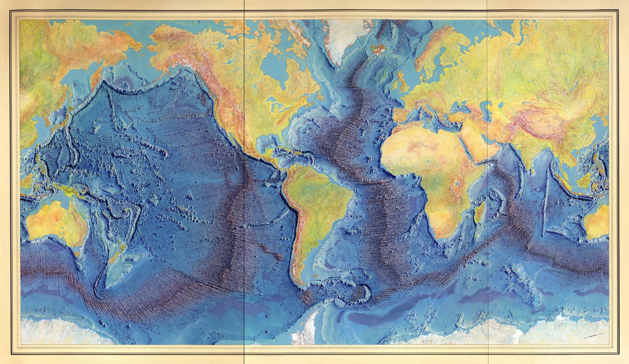
[1] Il Woods Hole Oceanographic Institution ha riferito che Marie Tharp è stata inserita nella National Women’s Hall of Fame nel 2026. Usando migliaia di rilevamenti sonar provenienti da navi da ricerca, Tharp e Bruce Heezen hanno scoperto una dorsale sottomarina lunga 40.000 miglia che circonda il globo, contribuendo a confermare la teoria della tettonica a zolle e della deriva dei continenti, che all’epoca erano controverse tra i geologi. Questo lavoro ha portato Tharp a creare la Mappa mondiale del fondale oceanico, pubblicata nel 1977 dall’Office of Naval Research e ancora oggi ampiamente utilizzata. La Columbia Climate School ha creato una mappa web interattiva, intitolata “Mappa mondiale del fondale oceanico di Heezen–Tharp”.
I ricercatori della Tufts University, guidati da Farshid Vahedifard, hanno analizzato oltre 190 milioni di punti di misurazione satellitari e terrestri lungo la costa degli Stati Uniti e hanno scoperto che il 71,5% delle aree sta sprofondando di oltre un millimetro all’anno. La costa del Golfo è quella che sta sprofondando di più: il 92,6% dei punti di misurazione mostra un movimento verso il basso a una velocità mediana di 2,5 millimetri all’anno. Lo studio incrocia inoltre la mappa del cedimento con i dati sulla popolazione e sulle infrastrutture, rilevando un impatto sproporzionato sulle comunità svantaggiate.
La NATO intende acquisire una mappa di base vettoriale globale conforme allo standard STANAG 2592 NGIF per supportare servizi di mappatura web, mappatura rapida, analisi geospaziale, calcolo di percorsi e geolocalizzazione. Il pacchetto si concentrerà sui dati vettoriali, combinando le attuali mappe Overture con i dati forniti dai fornitori e altre fonti aperte o fornite dall’acquirente, insieme a prodotti derivati come cache raster e vettoriali, reti percorribili e file di geolocalizzazione. L’appalto ha un valore stimato di 3,5 milioni di euro e l’aggiudicazione è prevista per febbraio 2027.
Un musicista lituano, che si definisce “mitografo”, ha rinominato su Google Maps una suggestiva formazione rocciosa sul Predigtstuhl, vicino a Bad Reichenhall, da “Teufelssattel” a “Wächter der Alaunen” – in onore di un’antica tribù celtica che lo affascina, mentre il nome storico è documentato già nel 1580 da Philipp Apian. L’associazione storica locale, guidata dall’archivista comunale Johannes Lang, ha quindi contattato Google, poiché l’ente catastale bavarese competente aveva omesso il nome dalla mappa solo per motivi grafici, senza però sostituirlo. È stato solo grazie al supporto tecnico di un informatico che il vecchio nome è stato ripristinato con successo. Lang vede in questo un esempio della crescente tendenza verso la “storiografia emotiva”. Ne parla anche il programma BR Quer al minuto 00:39.
MapTheNet mostra una mappa web dei siti internet. I domini sono posizionati vicino agli altri collegati a loro e ridimensionati in base al numero di link in entrata ponderati. Inoltre, puoi cercare un dominio e vedere come è collegato agli altri, come nel caso di weeklyosm.eu.
Prossimi eventi
| Nazione | Dove | venue | Cosa | Quando |
|---|---|---|---|---|
| 🇮🇳 | Kottayam | Mapathon Pre-event SotM Kerala 2026  | 2026-10-01 - 2026-10-05 | |
| 2026-10-01 | |||
| 🇫🇷 | Angers | L’Arrière Train, 3 rue de Frémur, Angers | Angers Rencontre mensuelle OpenStreetMap | 2026-10-01 |
| 🇫🇷 | Bar Le Schmilblik | Rencontre mensuelle des contributeurs Paris sud | 2026-10-01 | |
| 🇮🇹 | Messina | Fablab Messina (via Croce Rossa 63, 98124 Messina) | Hackathon Wikimedia & OSM | 2026-10-02 - 2026-10-04 |
| 🇩🇪 | Essen | Linuxhotel Essen | FOSSGIS-OSM-Communitytreffen Nr. 26 im Linuxhotel | 2026-10-02 - 2026-10-04 |
| 🇫🇷 | Mairie de Laillé | OSM Mapping | 2026-10-03 | |
| 🇪🇸 | Langreo | Casa de la Cultura “Escuelas Dorado” | GeoCamp 2026 | 2026-10-03 |
| 🇮🇳 | नई दिल्ली | Jitsi Meet (online) | OSM India - Monthly Online Mapathon | 2026-10-03 |
| 🇩🇪 | Essen | Verkehrs- und Umweltzentrum | Essen OSM-Treffen | 2026-10-03 |
| 🇮🇳 | Chennai Corporation | Velachery, Chennai | Chennai GLUG Velachery OSM Mapping | 2026-10-04 |
| TNEI Mapathon 2026 | 2026-10-05 | |||
| 🇹🇼 | 臺北市 | MozSpace Taipei | OpenStreetMap x Wikidata Taipei #93 | 2026-10-05 |
| 🇨🇭 | Bern | SBB Headquarter | Open Transport Community Conference 2026 | 2026-10-06 - 2026-10-09 |
| 🇦🇹 | Salzburg | Bewohnerservice Elisabeth-Vorstadt | OSM-Treffpunkt | 2026-10-06 |
| 🇬🇧 | Sheffield | Rutland Arms | OSM Sheffield - Monthly Social | 2026-10-06 |
| 🇪🇸 | Madrid | Online | Mappy Hour OSM España | 2026-10-06 |
| 🇩🇪 | Braunschweig | Stratum 0 | Braunschweiger Mappertreffen im Stratum 0 Hackerspace | 2026-10-06 |
| Missing Maps London Mapathon Beginner Friendly (with Training) (Online) [eng] | 2026-10-06 | |||
| iD Community Chat | 2026-10-07 | |||
| 🇬🇭 | Ghana | Everywhere She Maps workshop 2026 | 2026-10-07 - 2026-10-08 | |
| 🇮🇹 | Milano | Building 4, SRN 4.1.1 Politecnico di Milano | PoliMappers Maptedì | 2026-10-07 |
| 🇸🇰 | Žilina | Fakulta riadenia a informatiky UNIZA | Missing Maps mapathon Žilina #24 | 2026-10-07 |
| 🇧🇪 | Liège | Barricade, Liège | Carto party OpenStreetMap Café Crypté Liège | 2026-10-07 |
| 🇩🇪 | Stuttgart | Forum 3 Café | Stuttgarter OpenStreetMap-Treffen | 2026-10-07 |
| 🇪🇸 | Barcelona | Barcelona | Junta d’OpenStreetMap Català | 2026-10-07 |
| th | กรุงเทพมหานคร | Brighton College Bangkok Mapathon | Missing Maps Mapathon (Beginner) - Bangkok, Thailand | 2026-10-08 |
| 🇧🇪 | Bruxelles - Brussel | Galerie Bortier | Brussels meetup - byebye Thierry & Joost | 2026-10-08 |
| 🇩🇪 | Bochum | Das Labor, Alleestraße 50, Bochum | OSM-Treffen Bochum | 2026-10-08 |
| 🇩🇪 | Berlin | Grosse Hamburger Strasse 37, 10115 Berlin | 220. OSM-Stammtisch Berlin-Brandenburg | 2026-10-09 |
| 🇨🇭 | Bern | irgendwo im Breitsch, wird noch definiert | OSM-Znacht in Bern | 2026-10-09 |
| 🇮🇹 | Catania | Biblioteche Riunite Civica e A. Ursino Recupero | Modifichiamo Wiki e OSM insieme! - Catania | 2026-10-10 |
| 🇫🇷 | Angers | École Nationale Supérieure d’Arts et Métiers | OpenStreetMap, des cartes à la carte ! | 2026-10-10 |
| 🇩🇰 | København | Cafe Bevar’s | OSMmapperCPH | 2026-10-11 |
| 🇫🇷 | Angers | École Nationale Supérieure d’Arts et Métiers | OpenStreetMap, des cartes à la carte ! | 2026-10-11 |
| 🇮🇳 | New Delhi | East Delhi | OSM Delhi Mapping Party No.33 (East Zone) | 2026-10-11 |
| Panoramax Nederland - Online Community Meeting #1 | 2026-10-12 | |||
| CartONG : Mapathons en ligne 2026-2027 | 2026-10-12 | |||
| 🇳🇱 | Amsterdam | TomTom HQ | 2026 Autumn Maptime | 2026-10-12 |
| 🇩🇪 | München | Echardinger Einkehr | Münchner OSM-Treffen | 2026-10-13 |
| 🇩🇪 | Hamburg | Voraussichtlich: “Variable”, Karolinenstraße 23 | Hamburger Mappertreffen | 2026-10-13 |
| 🇩🇪 | temporärhaus | OSM-Stammtisch Ulm/Neu-Ulm | 2026-10-13 | |
| 🇬🇧 | Canolfan Cefnfaes | 🏴 North Wales Mapathon Gogledd Cymru 🏴 | 2026-10-14 | |
| 🇪🇸 | Barcelona | Barcelona | Assemblea d’OpenStreetMap Català | 2026-10-14 |
| 🇧🇪 | Bruxelles - Brussel | Tour & Taxis, Avenue du Port 86C - 1000 Brussels | FOSS4G Belgium | 2026-10-15 |
| OSMF Engineering Working Group meeting | 2026-10-16 | |||
| 🇦🇷 | Pergamino | Hub de Innovación | Encuentro OSM Argentina 2026 | 2026-10-17 |
| 🇫🇷 | Metz | Espace Arob@se - Metz | Atelier OpenStreetMap Metz | 2026-10-17 |
Questa Notiziario Settimanale OSM è stato prodotto da AnisKoutsi, Mannivu, MarcoR, MatthiasMatthias, Nakaner, Raquel Dezidério Souto, Strubbl, Andrew Davidson, derFred.
Lascia un commento