Tygodnik OSM 845
We are looking for volunteers to help us translate! Please get in touch with us: info@weeklyOSM.eu
24/09/2026-30/09/2026
About us
- We’re excited to announce that weeklyOSM is now accessible via news.osm.org, honouring the voices and contributions of our global community equally. The new domain redirects to weeklyOSM.eu.
Mapping campaigns
- Eugene Alvin Villar announced the #31DayOSMChallenge proposed by the OpenStreetMap Foundation’s Local Chapters and Communities Working Group. See the Daily Challenges and note that you don’t have to contribute every day.
Community
Raquel Dezidério Souto wrote, in her OSM User Diary, that she has edited two new volumes of the book Case Studies in Collaborative and Participatory Mapping (one of which is a thematic dossier on risk and disaster reduction). She authored chapters on the application of OpenStreetMap in two case studies conducted in collaboration with the Brazilian Ministry of Integration and Regional Development (part of volume 2). In total, 35 chapters were published, and the two e-books are available as open access on the Editora IVIDES portal.
In Episode 284 of the Libre à Vous podcast, Anne L’Hôte presented a segment titled ‘complete your street’.
In a blog post Christoph Hormann reflected on the challenges of communication within open-source communities such as OpenStreetMap. He highlighted how language barriers, differing cultural backgrounds, and the peculiarities of digital text-based communication can lead to misunderstandings in discussions, and calls for greater understanding and thoughtfulness in these exchanges.
Reddit user u/Legitimate-Weight768 is currently mapping their hometown in Marcílio Dias, Canoinhas, Santa Catarina, Brazil, and is asking on Reddit for tips on how to improve their mapping skills with OSM.
The Wikimedia Ghana User Group has organised Wiki Loves Places 2026 in Ghana, aiming to collect at least 250 geotagged images of places, document 250 new place entities on Wikidata, and add or update 250 locations on OpenStreetMap.
A local category for Kalaallit Nunaat (Greenland) has been set up on the OSM Community forum.
9_tab has written about Planet Trails in Switzerland. How many are there on OSM? How detailed is the mapping? What scale do they use? Do they include Pluto? What else? Which trails may be missing?
OpenStreetMap Foundation
Dorothea Kazazi announced that the OSMF board candidates’ manifestos and answers to the official questions, by Brian Sperlongano, are now available on the OSM Wiki.
Christoph Hormann discussed the upcoming OSMF board election 2026, saying that having four candidates for four seats makes the election ‘meaningless’ and could seriously damage the board’s legitimacy as a democratically elected representation of OSMF members.
Local chapter news
OpenStreetMap US has published its September 2026 newsletter.
InsertUser tooted that UK-based OSM mappers were able to vote for the next UK quarterly project until 28 September.
Events
The Centro Argentino de Cartografía (CAC) has posted a reminder on LinkedIn that the registration deadline for the 13th Congreso de la Ciencia Cartográfica, which is also the 4th Congreso Virtual Internacional, was 30 September 2026. The virtual congress will take place from 6 to 8 October 2026 and is being jointly organised by the CAC and the Argentine Instituto Geográfico Nacional.
Alpha Amadou Diallo reported that the municipality of Pire Goureye, Senegal hosted a collaborative mapping training activity with OpenStreetMap on 26 and 27 September 2026.
Education
- Nelson Gonçalves published learning material introducing web mapping and uMap.
OSM research
- Thiago Kikuchi and others have developed ► an interactive uMap showing the physical environment of urban river basins in Northern Paraná, Brazil, combining publicly available data on contour lines, slopes, soil types, hydrography, water bodies, springs, and watershed boundaries.
Maps
Mark Dimond used OSMnx to visualise which road in England carries the most buses.
Martin has developed a map that shows which konbini is closest to you in Tokyo and which chain dominates each area, using OpenStreetMap data.
NoEscapeMap has developed NoEscape 2.0, a web map that geocodes past cases of border-crossing attempts from Ukraine’s open court registry data, intended to help tourists and researchers analyse ► risks and avoid ► danger.
Stamen Design reported that their partner Stadia Maps has updated the underlying data used in several of Stamen’s basemaps, focusing on an overhaul of water features, such as rivers, lakes, and coastlines.
Map Amore showcased ‘The Arrogance of Space Mapping Tool’, a tool that shows how much space cars occupy in our cities.
Ogmios has built World Wide Waterways: Flussdiagram.me, a website where waterways are rendered in 1D maps with additional metadata from OpenStreetMap and Wikidata.
OSM in action
Sozialheld*innen has launched ► a11y-Score, a tool that makes accessibility in Germany visible and comparable through a score from 0 to 100 for federal states, 418 districts and independent cities, along with Germany as a whole, based on OpenStreetMap geodata.
BoxThisLap reported on TerraDrive, a new open-source map generator that converts OpenStreetMap and elevation data into driveable 3D environments. Released under the MIT licence, the tool utilises OSM’s road geometry, lane details, intersections, and building footprints to recreate real-world road networks, which can then be exported as playable levels for the vehicle simulation game BeamNG.drive.
Spino87 posted PizzaRank, a directory of 30,931 Italian pizzerias, a good 24,000 of which were sourced from OpenStreetMap, and also made the OSM portion available ► as a .CSV or .JSON file under the ODbL licence, as simple attribution is not sufficient for a derived database work. On the OSM Community forum he asked for advice on how to report any errors found in the process back to OSM; in discussions with Martin Koppenhöfer it emerged that the duplicates and incorrect municipality names were due to peculiarities of the osmium export tool or his own script, whilst the six pizzerias that have permanently closed should now be reported individually as notes. The data also revealed that the
oven=wood_firedtag has hardly been used to date, which is why both suggested promoting it more actively via presets and a StreetComplete quest.
Open Data
After twenty years of service, IGN France is replacing ► Geoportail with its new portal designed as a single point of access to maps and territorial geographic data. The goal is to make the map an accessible, open, and useful digital tool both for everyday use and for major decisions, whether you’re simply curious, a hiker, a local elected official, or a professional. It contains maps from IGN and its partners, aerial photographs, and various maps (cadastral, forests, historical, topographic, and routes, etc).
Jake Low announced that Layercake, a distribution of OpenStreetMap data separated into thematic layers and converted into GeoParquet format, has a new website.
Software
Tykayn showcased Qualiwiki, a web dashboard to compare the content coverage between the English and French versions of the OSM Wiki.
The PapaMap shows the nearest changing table that parents can reach using OpenStreetMap data and is now available as an iPhone app, with an Android version currently in development.
Tobias Zwick announced the first public beta of StreetComplete for iOS.
Programming
HeiGIT introduced HeiSlime, a Python toolbox that uses OpenStreetMap context to select images useful for analysis before processing them with a computer vision model. The result is a smaller, more targeted image set that saves processing time.
The OSMF sysadmins tooted that upgrading to Mapnik 4.3.2 lead to significant performance improvements for raster tile rendering. On top of that, there are technical improvements to OSM Carto by leijuv and nakaner. Detailed explanations can be found on GitHub. Another, as yet unmerged, pull request to OSM Carto promises more performant sorting of features.
Sarah Hoffmann reported that Kai Johnson has improved the CPU usage metering per client on an Overpass server. The measurements are used to ban heavy users by IP address and/or application. She also noted that most of the bad traffic comes from poorly programmed speed camera apps.
In two Habr articles, Sunspirit described how his desire to create his own walking route led to the development of the route planner putemer.ru. In a follow-up technical article he explained why he switched from live Overpass API queries to his own OSM database, built from Geofabrik extracts and including a PMTiles map set, and uses elevation data, road network counts, plus cache settings, and how easily plausible measurements can lead to false conclusions.
Releases
Amanda McCann recently added several new features to WaterwayMap, including multilingual names and integration with Wikidata and Wikipedia.
Michael Johnson released NodeODM 3.6.2 to match the latest OpenDroneMap 3.6.2 release.
Other “geo” things
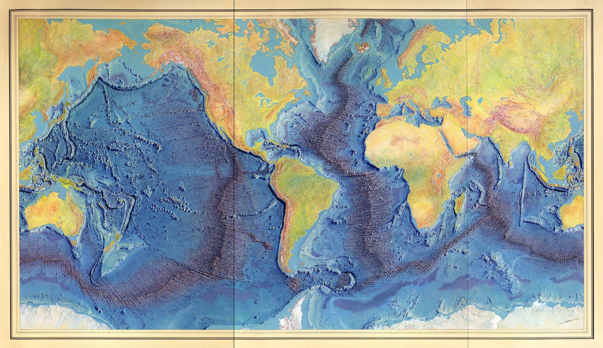
[1] The Woods Hole Oceanographic Institution reported that Marie Tharp was inducted into the National Women’s Hall of Fame in 2026. Using thousands of sonar readings from research vessels, Tharp and Bruce Heezen revealed a 40,000-mile underwater ridge girdling the globe, helping confirm plate tectonics and continental drift theory, which were controversial among geologists at the time. This work led Tharp to create the World Ocean Floor Map, published in 1977 by the Office of Naval Research and still widely used today. The Columbia Climate School has made an interactive guide to the ‘Heezen–Tharp World Ocean Floor Map’.
Researchers at Tufts University, led by Farshid Vahedifard, have analysed more than 190 million satellite and ground measurement points along the US coastline and found that 71.5% of the areas are sinking by more than one millimetre per year. The Gulf Coast is sinking the most, with 92.6% of measurement points showing downward movement at a median rate of 2.5 millimetres per year. The study also overlaid the subsidence map with population and infrastructure data and found a disproportionate impact on disadvantaged communities.
NATO is seeking to procure a global vector basemap compliant with STANAG 2592 NGIF to support web mapping, rapid mapping, geospatial analysis, routing, and geolocation services. The package will centre on vector data combining current Overture Maps data with vendor-furnished data and other open or purchaser-provided sources, alongside derived products such as raster and vector caches, routable networks, and geolocator files. The procurement has an estimated value of EUR 3.5 million and is expected to be awarded in February 2027.
A Lithuanian musician and self-styled ‘mythographer’ has renamed ► a striking rock formation at the Predigtstuhl, near Bad Reichenhall, on Google Maps from ‘Teufelssattel’ to ‘Wächter der Alaunen’ (after an ancient Celtic tribe that fascinates him) whereas the historical name is documented as early as 1580 by Philipp Apian. The local historical society, led by town archivist Johannes Lang, subsequently contacted Google, as the responsible Bavarian surveying authority had omitted the name from its map solely for graphical reasons, but had not replaced it. It was only with the technical support of a computer scientist that the old name was successfully restored. Lang sees this as an example of the growing trend towards ’emotional historiography’. The BR Quer programme also reported this at 00:39.
MapTheNet displays a map of websites. Domains are placed near other domains they are linked to, and scaled according to the number of weighted incoming links. You can search a domain and see how it is connected to others, for example weeklyosm.eu.
Upcoming Events
| Country | Where | Venue | What | When |
|---|---|---|---|---|
| 🇮🇳 | Kottayam | Mapathon Pre-event SotM Kerala 2026  | 2026-10-01 - 2026-10-05 | |
| 🇮🇹 | Messina | Fablab Messina (via Croce Rossa 63, 98124 Messina) | Hackathon Wikimedia & OSM | 2026-10-02 - 2026-10-04 |
| 🇩🇪 | Essen | Linuxhotel Essen | FOSSGIS-OSM-Communitytreffen Nr. 26 im Linuxhotel | 2026-10-02 - 2026-10-04 |
| 🇪🇸 | Langreo | Casa de la Cultura “Escuelas Dorado” | GeoCamp 2026 | 2026-10-03 |
| 🇫🇷 | Mairie de Laillé | OSM Mapping | 2026-10-03 | |
| 🇮🇳 | नई दिल्ली | Jitsi Meet (online) | OSM India - Monthly Online Mapathon | 2026-10-03 |
| 🇩🇪 | Essen | Verkehrs- und Umweltzentrum | Essen OSM-Treffen | 2026-10-03 |
| 🇮🇳 | Chennai Corporation | Velachery, Chennai | Chennai GLUG Velachery OSM Mapping | 2026-10-04 |
| TNEI Mapathon 2026 | 2026-10-05 | |||
| 🇹🇼 | 臺北市 | MozSpace Taipei | OpenStreetMap x Wikidata Taipei #93 | 2026-10-05 |
| 🇨🇭 | Bern | SBB Headquarter | Open Transport Community Conference 2026 | 2026-10-06 - 2026-10-09 |
| 🇬🇧 | Sheffield | Rutland Arms | OSM Sheffield - Monthly Social | 2026-10-06 |
| 🇪🇸 | Madrid | Online | Mappy Hour OSM España | 2026-10-06 |
| 🇦🇹 | Salzburg | Bewohnerservice Elisabeth-Vorstadt | OSM-Treffpunkt | 2026-10-06 |
| 🇩🇪 | Braunschweig | Stratum 0 | Braunschweiger Mappertreffen im Stratum 0 Hackerspace | 2026-10-06 |
| Missing Maps London Mapathon Beginner Friendly (with Training) (Online) [eng] | 2026-10-06 | |||
| iD Community Chat | 2026-10-07 | |||
| 🇬🇭 | Ghana | Everywhere She Maps workshop 2026 | 2026-10-07 - 2026-10-08 | |
| 🇮🇹 | Milano | Building 4, SRN 4.1.1 Politecnico di Milano | PoliMappers Maptedì | 2026-10-07 |
| 🇸🇰 | Žilina | Fakulta riadenia a informatiky UNIZA | Missing Maps mapathon Žilina #24 | 2026-10-07 |
| 🇧🇪 | Liège | Barricade, Liège | Carto party OpenStreetMap Café Crypté Liège | 2026-10-07 |
| 🇪🇸 | Barcelona | Barcelona | Junta d’OpenStreetMap Català | 2026-10-07 |
| 🇩🇪 | Stuttgart | Forum 3 Café | Stuttgarter OpenStreetMap-Treffen | 2026-10-07 |
| th | กรุงเทพมหานคร | Brighton College Bangkok Mapathon | Missing Maps Mapathon (Beginner) - Bangkok, Thailand | 2026-10-08 |
| 🇧🇪 | Bruxelles - Brussel | Galerie Bortier | Brussels meetup - byebye Thierry & Joost | 2026-10-08 |
| 🇩🇪 | Bochum | Das Labor, Alleestraße 50, Bochum | OSM-Treffen Bochum | 2026-10-08 |
| 🇩🇪 | Berlin | Grosse Hamburger Strasse 37, 10115 Berlin | 220. OSM-Stammtisch Berlin-Brandenburg | 2026-10-09 |
| 🇨🇭 | Bern | irgendwo im Breitsch, wird noch definiert | OSM-Znacht in Bern | 2026-10-09 |
| 🇮🇹 | Catania | Biblioteche Riunite Civica e A. Ursino Recupero | Modifichiamo Wiki e OSM insieme! - Catania | 2026-10-10 |
| 🇫🇷 | Angers | École Nationale Supérieure d’Arts et Métiers | OpenStreetMap, des cartes à la carte ! | 2026-10-10 |
| 🇩🇰 | København | Cafe Bevar’s | OSMmapperCPH | 2026-10-11 |
| 🇫🇷 | Angers | École Nationale Supérieure d’Arts et Métiers | OpenStreetMap, des cartes à la carte ! | 2026-10-11 |
| 🇮🇳 | New Delhi | East Delhi | OSM Delhi Mapping Party No.33 (East Zone) | 2026-10-11 |
| Panoramax Nederland - Online Community Meeting #1 | 2026-10-12 | |||
| CartONG : Mapathons en ligne 2026-2027 | 2026-10-12 | |||
| 🇳🇱 | Amsterdam | TomTom HQ | 2026 Autumn Maptime | 2026-10-12 |
| 🇩🇪 | München | Echardinger Einkehr | Münchner OSM-Treffen | 2026-10-13 |
| 🇩🇪 | Hamburg | Voraussichtlich: “Variable”, Karolinenstraße 23 | Hamburger Mappertreffen | 2026-10-13 |
| 🇩🇪 | temporärhaus | OSM-Stammtisch Ulm/Neu-Ulm | 2026-10-13 | |
| 🇬🇧 | Canolfan Cefnfaes | 🏴 North Wales Mapathon Gogledd Cymru 🏴 | 2026-10-14 | |
| 🇪🇸 | Barcelona | Barcelona | Assemblea d’OpenStreetMap Català | 2026-10-14 |
| 🇧🇪 | Bruxelles - Brussel | Tour & Taxis, Avenue du Port 86C - 1000 Brussels | FOSS4G Belgium | 2026-10-15 |
| OSMF Engineering Working Group meeting | 2026-10-16 | |||
| 🇦🇷 | Pergamino | Hub de Innovación | Encuentro OSM Argentina 2026 | 2026-10-17 |
| 🇫🇷 | Metz | Espace Arob@se - Metz | Atelier OpenStreetMap Metz | 2026-10-17 |
This weeklyOSM was produced by MatthiasMatthias, Nakaner, PierZen, Raquel Dezidério Souto, Strubbl, Andrew Davidson, barefootstache, derFred.
We welcome link suggestions for the next issue via this form and look forward to your contributions.
Leave a reply